Situation Summary
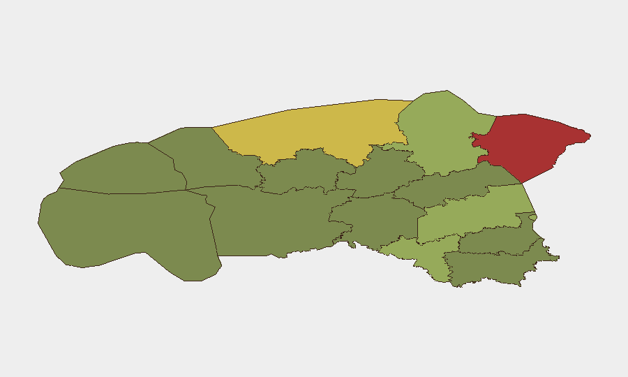
Estonia faces elevated near-term security pressure from a convergence of hybrid-attack vectors: Belarus-driven irregular migration surges across the southern and eastern borders, confirmed airspace violations involving weaponized drones originating from the Russia–Ukraine theater, and heightened law-enforcement activity in urban centers. The national threat ranking remains composite 13 globally, but sub-national concentration—particularly in Ida-Viru (78) and Harju (68) counties—reflects genuine operational strain on border and capital-region security infrastructure. The trajectory is one of acute, sustained pressure rather than systemic breakdown; however, escalation in drone incursions or coordinated border incidents could rapidly shift the risk posture.
Key Developments
- Tallinn, Nõmme district (2 August): Police executed a large-scale raid resulting in detention of 12 foreign nationals suspected of illegal entry; operation included drone surveillance and suggests organized migrant routing networks active in the capital region.
- Estonia–Belarus and Latvia–Belarus border sectors (2–3 August): Estonian Police and Border Guard Board deployed rotating units to reinforce southern border controls in direct response to 63 migrant apprehensions in the past week (102 year-to-date), publicly attributing surge to Belarus-coordinated hybrid-attack pressure.
- South Estonia, near Russian border (2–3 August reporting): Estonian Defence Forces reiterated recovery of an explosive-laden drone (5 kg payload) that penetrated airspace from Russian territory; likely sourced from Ukraine conflict. Incident prompted temporary airspace restrictions along sensitive border sections.
- Tallinn airspace (3 August): Russia state media reported Estonia closed flights along portions of its border with Russia until nightfall, citing security concerns tied to the aforementioned drone discovery and elevated airspace risk assessment.
- National police communications (2–3 August): Police announced relaxation of speed-camera fine thresholds while simultaneously reporting increased frequency of bomb-threat calls, signaling elevated public-security alert status and possible copycat or false-alarm activity.
- Tõrva, Valga County (2 August): Local evacuation of 10 residents due to flooding; infrastructure disruption and access constraints in South Estonia, compounding border-region operational challenges.
- Narva and border-town discourse (2–3 August): Social and mainstream media commentary emphasizes heightened security focus and tension in border municipalities, particularly Narva, reinforcing travel and operational-security concerns in Russian-border proximity zones.
Highest-Risk Areas
Ida-Viru and Harju counties dominate the risk profile. Ida-Viru (78) encompasses Narva and the Russian border—the primary conduit for drone and hybrid-threat activity—and sits at the nexus of irregular migration and airspace violations. Harju (68), which includes Tallinn and its urban-migration choke points (notably Nõmme), is experiencing organized detentions and coordinated migrant staging. Tartu, Valga, and Lääne-Viru counties (58–52) form a secondary arc of pressure spanning the Belarus and Russian borders, where hybrid-attack infrastructure and migrant routing remain active.
How GeoBit Would Assist
Security teams should employ AOI Monitoring & Early Warning on Ida-Viru and Harju counties to detect surge patterns in migrant activity and police operations with real-time alerting; couple this with OSINT Fusion & Corroboration (X/Telegram, local police scanner signals, media feeds) to separate credible incidents from false reports and social-media amplification. Routing & Network Analysis can identify alternative access paths into Estonia and forecasted migrant chokepoints, enabling duty-of-care teams to adjust staffing and logistics in high-risk zones.
7-Day Outlook
Migration pressure and drone incursions are expected to persist at current or elevated levels through mid-August, with Belarus-driven activity likely to remain episodic rather than cascading. Airspace restrictions and police operations will continue; a second confirmed drone or coordinated multi-vector incident would trigger expanded military or NATO-coordination responses. Travel and asset-security risk remains *elevated but manageable* outside Ida-Viru and central Tallinn.
Highest-Risk Areas — Ranked
| # | State / Region | Risk |
|---|---|---|
| 1 | Ida-Viru County | 78 |
| 2 | Harju County | 68 |
| 3 | Tartu County | 58 |
| 4 | Valga County | 55 |
| 5 | Lääne-Viru County | 52 |
| 6 | Pärnu County | 35 |
| 7 | Rapla County | 32 |
| 8 | Jõgeva County | 30 |
| 9 | Järva County | 28 |
| 10 | Viljandi County | 25 |
| 11 | Põlva County | 22 |
| 12 | Võru County | 18 |
Sources
Previous Daily Briefs
A new Estonia brief is written every day — each with its own risk map and downloadable CSV. Here's the last week; use the calendar to go further back.
📅 Browse every day by calendar →
Highlighted days have a brief. Tap a day for that day's map & analysis, or “csv” for that day's dataset ($5).
Atlas — our AI intelligence desk — emails them this snapshot personally. Nothing else, no list.