Situation Summary
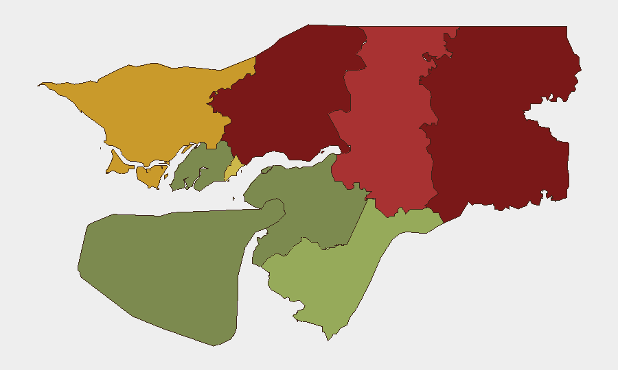
Guinea-Bissau remains under military-led transitional rule ahead of presidential and legislative elections scheduled for 6 December 2026. The country ranks #115 globally on composite threat assessment with no tracked critical security events in the reporting period. Political stability is the primary concern; northern and eastern border regions (Gabu, Oio, Bafatá) carry substantially elevated risk, while the capital and surrounding areas show moderate threat levels. The near-term trajectory depends on the conduct and acceptance of December elections and enforcement of ongoing military-order directives.
Key Developments
- Bissau, 27 September 2026: Law-enforcement forces occupied the headquarters of the African Party for the Independence of Guinea and Cape Verde (PAIGC) near National Heroes Square and the presidency, enforcing a military order requiring political-party offices to relocate away from state institutions. This marks a significant assertion of military authority over the political establishment during the transitional period.
- Safim–Jugudul corridor, National Road 1, 27 September 2026: The West African Development Bank approved CFAF 30 billion (~$52 million USD) for the first phase of upgrades to a 40-kilometre road section. Infrastructure improvements in this transport corridor may reduce security risks associated with poorly maintained roads but warrant monitoring for construction-phase disruption.
- Bissau / nationwide, 25 September 2026: Prime Minister Ilídio Vieira Té reiterated to the UN General Assembly that 6 December presidential and legislative elections will proceed and be conducted freely, confirming the military-led transitional government's stated commitment to electoral timelines.
- Nationwide, 25 September 2026: A referendum concerning presidential powers was reported ahead of the December elections; insufficient independent corroboration is available on its conduct, turnout, and outcome to assess security implications at this stage.
- Safende region (ongoing from 16 September): Members of the Guinean community reported assaults, robberies, and shootings; vandalism was also documented. This signifies localized intercommunal tensions and criminal activity in cross-border areas.
Highest-Risk Areas
Gabu Region (risk 92) and Oio Region (risk 85) in the north and northeast drive the country's composite threat score. Both regions lie along or near the Guinea border and have historically experienced trafficking, smuggling, and spillover violence from regional instability. Bafatá Region (78) and Cacheu Region (72) present similar exposure. The capital Bissau Autonomous Sector (68) reflects political volatility and enforcement actions such as the 27 September PAIGC headquarters occupation. Southern and island regions (Tombali, Quinara, Biombo, Bolama) carry substantially lower risk and remain relatively stable.
How GeoBit Would Assist
Security teams with people or assets in Guinea-Bissau should deploy AOI Monitoring & Early Warning on Gabu, Oio, and Bafatá regions to detect cross-border trafficking, communal violence, or election-related disruption. Intel Sweep and multi-language OSINT (X, Telegram, local news, radio) will track political rhetoric, military directives, and incident reporting during the nine-week run-up to elections. Routing & Network Analysis supports contingency planning for personnel movement in higher-risk northern corridors, while entity extraction and network analysis maintain visibility on key security actors and decision-makers throughout the transition.
7-Day Outlook
No imminent security crises are forecast, but the military-imposed relocation of political-party offices signals continued assertion of control that may provoke opposition pushback as election day approaches. Election-related tensions are likely to gradually increase through December. Border-region monitoring remains essential, particularly in Gabu and Oio, where criminal activity and intercommunal friction present persistent operational risks.
Highest-Risk Areas — Ranked
| # | State / Region | Risk |
|---|---|---|
| 1 | Gabu Region | 92 |
| 2 | Oio Region | 85 |
| 3 | Bafatá Region | 78 |
| 4 | Cacheu Region | 72 |
| 5 | Bissau Autonomous Sector | 68 |
| 6 | Tombali Region | 45 |
| 7 | Quinara Region | 38 |
| 8 | Biombo Region | 32 |
| 9 | Bolama Region | 15 |
Sources
Previous Weekly Briefs
A new Guinea-Bissau brief is written every Monday, covering the week — each with its own risk map and downloadable CSV. Use the calendar to go further back.
- September 21, 2026
- September 14, 2026
- September 7, 2026
- September 1, 2026
- August 30, 2026
- August 28, 2026
- August 26, 2026
📅 Browse past briefs by calendar →
Highlighted days have a brief. Tap a day for that day's map & analysis, or “csv” for that day's dataset ($5).
Atlas — our AI intelligence desk — emails them this snapshot personally. Nothing else, no list.