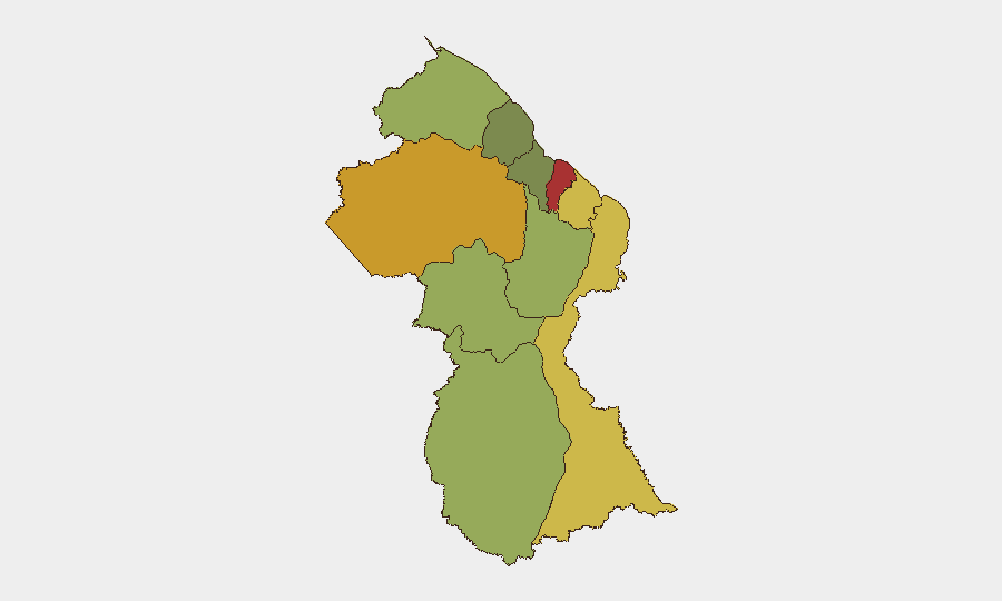
Situation Summary
Guyana remains a moderate-risk environment (global rank #69, composite threat score 17) with significant sub-national variation. Political tensions surfaced on 13 July involving presidential-prosecutor disagreements and an ongoing investigation into the president, though no civil unrest or security incidents are confirmed in the last 48 hours. Crime and informal armed activity remain concentrated in the interior mining regions and border areas; coastal urban centers present lower acute risk but ongoing street crime.
Key Developments
No verified security incidents or civil unrest have been reported in Guyana during the 24–48 hour window (12–14 July 2026). Available open-source reporting does not corroborate discrete events (protests, violence, infrastructure disruption, or notable crime) specific to this timeframe. The most recent verifiable incidents in public record date to early July or earlier:
- Political tension signal (13 July): Presidential disapproval and investigation announcement registered on event monitoring; specific operational impact on security posture not yet evident in accessible reporting.
- Baseline crime context (pre-12 July): Murders and armed incidents in Demerara-Mahaica, East Berbice-Corentyne, and Cuyuni-Mazaruni (the interior gold-mining belt) represent standing patterns rather than fresh events. These areas remain persistently higher-risk.
Corporate security teams should monitor the 13 July political signals for escalation but should not assume imminent destabilization absent corroborating field or civil-unrest indicators in the coming days.
Highest-Risk Areas
Demerara-Mahaica (risk 78) and Cuyuni-Mazaruni (risk 72) drive the national threat profile. Demerara-Mahaica encompasses Georgetown and the coastal industrial belt—theft, armed robbery, and gang violence affect corporate facilities, supply chains, and personnel movement. Cuyuni-Mazaruni, the interior gold-mining frontier, experiences informal security, labor disputes, border friction with Venezuela, and sporadic armed clashes. Mahaica-Berbice and East Berbice-Corentyne (risks 65, 62) follow; both include agricultural and mining activity with localized crime and occasional cross-border movement. The remaining interior regions (Potaro-Siparuni, Barima-Waini, Upper Takutu-Upper Essequibo) are lower-density but remote, presenting logistics and medical-evacuation challenges. Coastal and island zones (Pomeroon-Supenaam, Essequibo Islands) are lower-risk but isolated.
How GeoBit Would Assist
Intel Sweep and OSINT fusion would monitor political messaging, opposition statements, and prosecutor activity for escalation signals beyond the 13 July announcement. AOI Monitoring & Early Warning with persistent satellite and social-media watch on Demerara-Mahaica and Cuyuni-Mazaruni would detect protest formation, road closures, or armed activity before corporate personnel encounter disruption. Network & Actor Analysis would track informal security groups, labor unions, and border militias known to operate in mining zones, enabling route planning and workforce movement decisions.
7-Day Outlook
No immediate security deterioration is forecast. Political tension may persist, but absent mass mobilization or security-force action, operational risk for corporate activity remains elevated but stable. Baseline crime and informal mining-sector violence will likely continue; personnel in interior and coastal-urban high-crime zones should maintain heightened situational awareness and avoid high-value-display behavior. Monitor 15–17 July for any prosecutorial or political escalation that could trigger labor action or broader civil-society response.
Highest-Risk Areas — Ranked
| # | State / Region | Risk |
|---|---|---|
| 1 | Demerara-Mahaica | 78 |
| 2 | Cuyuni-Mazaruni | 72 |
| 3 | Mahaica-Berbice | 65 |
| 4 | East Berbice-Corentyne | 62 |
| 5 | Upper Demerara-Berbice | 58 |
| 6 | Potaro-Siparuni | 48 |
| 7 | Barima-Waini | 45 |
| 8 | Upper Takutu-Upper Essequibo | 42 |
| 9 | Pomeroon-Supenaam | 38 |
| 10 | Essequibo Islands | 35 |
Previous Daily Briefs
A new Guyana brief is written every day — each with its own risk map and downloadable CSV. Here's the last week; use the calendar to go further back.
📅 Browse every day by calendar →
Highlighted days have a brief. Tap a day for that day's map & analysis, or “csv” for that day's dataset ($5).
Atlas — our AI intelligence desk — emails them this snapshot personally. Nothing else, no list.