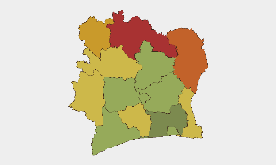
Situation Summary
Ivory Coast remains a stable middle-income country with composite threat score 25 globally (#68), but sub-national fragmentation is pronounced. The primary driver is localized civil unrest, most acute in the north and east. Recent intercommunal violence in the Alépé department (4–5 August) signals underlying tensions between autochthonous and allochthonous populations that warrant close monitoring in high-risk districts.
Key Developments
- Kossandji, Alépé department (4–5 August 2026): Violent intercommunal clashes between autochthonous Akyé youth and allochthonous Mossi/Lobi communities resulted in multiple deaths, injuries, property destruction, and burned dwellings. Incident was independently reported by multiple outlets and reflects persistent demographic friction in coastal/central zones.
- Koumassi, Abidjan (6 August 2026): President Ouattara announced government investigations into illegal evictions and demolition operations, signaling active political sensitivity around urban land disputes and enforcement actions in the capital.
- Port authority detention, location unconfirmed (8–10 August 2026): Ivorian security authorities detained a Comoros-flagged cargo vessel (IB Atlantic IV) following a maritime pursuit linked to transnational drug-trafficking activity originating in Liberia. Full cargo manifest and seizure details remain unconfirmed in available reporting.
- No verified nationwide protests or travel disruptions (8–10 August 2026): Open-source monitoring detected no new rioting, road blockades, or mass demonstrations affecting major transport corridors or commercial zones in the last 48 hours.
Highest-Risk Areas
Northern and eastern districts—Savanes, Zanzan, Denguélé, and Comoé (risk scores 78–70)—remain the primary threat drivers, reflecting chronic communal tensions, limited state presence, and cross-border mobility. Montagnes and Woroba districts (68, 65) follow, driven by similar factors. The capital Abidjan (risk 45) remains relatively stable despite urban displacement pressures; coastal and central zones (Gôh-Djiboua, Sassandra-Marahoué, Bas-Sassandra) score 58–52, reflecting lower but persistent intercommunal risk. The Kossandji incident underscores that violence is not geographically confined to the far north and requires active monitoring across multiple districts.
How GeoBit Would Assist
Security teams should deploy AOI Monitoring & Early Warning on the northern districts (Savanes, Zanzan, Denguélé) to track intercommunal flashpoints in near-real time, paired with Intel Sweep (X/Twitter, Telegram, local media OSINT) to detect emerging tensions before escalation. Network & Actor Analysis would map key communal leadership and grievance networks to support predictive early warning. For personnel in Abidjan or coastal zones, Routing & Network Analysis enables identification of alternative transit routes away from known friction zones; Satellite & Imagery analysis can support site-specific due diligence for facilities in disputed urban areas.
7-Day Outlook
The Kossandji violence is unlikely to trigger immediate nationwide contagion, but repeat incidents in demographically mixed zones are probable if underlying grievances—land access, resource competition, migrant integration—remain unaddressed. Government investigations into urban demolitions may reduce short-term enforcement-driven tensions but could also signal renewed state intervention capacity. Monitor for secondary incidents in Alépé, Lacs, and Vallée du Bandama districts over the next 7 days.
Highest-Risk Areas — Ranked
| # | State / Region | Risk |
|---|---|---|
| 1 | Savanes District | 78 |
| 2 | Zanzan District | 75 |
| 3 | Denguélé District | 72 |
| 4 | Comoé District | 70 |
| 5 | Montagnes District | 68 |
| 6 | Woroba District | 65 |
| 7 | Gôh-Djiboua District | 60 |
| 8 | Sassandra-Marahoué District | 58 |
| 9 | Vallée du Bandama District | 55 |
| 10 | Bas-Sassandra District | 52 |
| 11 | Lacs District | 48 |
| 12 | Abidjan | 45 |
Sources
Previous Daily Briefs
A new Ivory Coast brief is written every day — each with its own risk map and downloadable CSV. Here's the last week; use the calendar to go further back.
📅 Browse every day by calendar →
Highlighted days have a brief. Tap a day for that day's map & analysis, or “csv” for that day's dataset ($5).
Atlas — our AI intelligence desk — emails them this snapshot personally. Nothing else, no list.