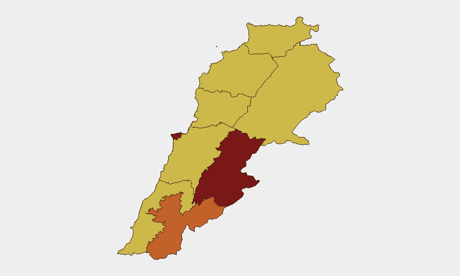
Situation Summary
Lebanon remains in active military escalation, with Israeli airstrikes and artillery strikes ongoing in southern and eastern regions, and US-brokered military talks underway to establish withdrawal zones and security arrangements. The composite threat score of 100 reflects sustained conventional military operations, cross-border fire, and civilian exposure across multiple governorates. The Beqaa Governorate (risk 99.6) and Beirut (risk 88) drive the national ranking, while southern border areas face direct kinetic activity. De-escalation mechanics are being negotiated in parallel with active combat operations, creating an unpredictable near-term security environment.
Key Developments
- Hermel, Baalbek-Hermel Governorate — 15 July: A gas tanker exploded after a fire sparked by extreme heat near a Lebanese Army barracks, damaging residential properties and vehicles. Civil Defense responded to extinguish the blaze. Secondary hazard risk (fuel/chemical infrastructure) is elevated in conflict zones.
- Southern Lebanon (Nabatieh al-Fawqa, Baraashit, Beit Yahoun, Rshaf) — 16 July: Israeli warplanes struck multiple locations and artillery shelled Rshaf. The Israeli military reported killing three Hezbollah members in Beit Yahoun. Strikes are consistent with ongoing southern border operations.
- Beirut — 16 July: Lebanon and Israel held US-sponsored military-level talks (including electronic meetings) to discuss implementation of pilot withdrawal zones and security arrangements. Talks signal potential near-term shift in operational posture but do not yet constrain active strikes.
- Beirut–Rafic Hariri International Airport — 11–13 July (recent context): Lebanese and Qatar Airways implemented heightened security screening, including passenger bans on pagers and walkie-talkies, reflecting sustained conflict-environment protocols.
- Tyre and Nabatiih Governorate — 11–12 July (recent context): Israeli strikes intensified; civilian displacement toward safer areas continued. South Governorate (risk 69.6) experiences the most direct exposure to cross-border military activity.
Highest-Risk Areas
Beqaa Governorate (99.6) and Beirut (88) carry the highest composite risk due to proximity to Israeli operations, Iranian/Hezbollah presence, and civilian density. The Beqaa hosts military infrastructure, militant organizations, and cross-border supply routes; Beirut's risk reflects political volatility, demonstration activity, and potential for secondary effects (aviation disruption, infrastructure targeting). Southern border governorates (Nabatieh 75.1, South 69.6) face direct kinetic exposure from Israeli strikes and artillery. North Governorate and Akkar (both 69.6) are elevated by spillover risk and potential secondary conflict spread if negotiations fail.
How GeoBit Would Assist
Security and duty-of-care teams would employ AOI Monitoring & Early Warning on Beqaa and Beirut facilities to receive real-time alerts on strike patterns and displacement; Conflict & Military (force structure, weapons-capability tracking) to anticipate Israeli and Hezbollah operational tempo; and Intel Sweep (global event feeds, X/Telegram OSINT, sentiment & temporal analysis) to track negotiation signals and public mood shifts that may precede rapid escalation or de-escalation. Routing & Network Analysis supports alternative travel and supply-line planning for personnel and assets in high-risk governorates.
7-Day Outlook
Ongoing military talks may slow but will not halt near-term strikes; Israeli operations in the south and east are likely to continue at current or elevated tempo through the negotiation window. Civilian casualty risk and infrastructure damage remain high in the Beqaa and southern border zones. A breakdown in US-brokered talks or a major incident (high-casualty strike, air-defense activation) could trigger rapid escalation within 48–72 hours.
Highest-Risk Areas — Ranked
| # | State / Region | Risk |
|---|---|---|
| 1 | Beqaa Governorate | 99.6 |
| 2 | Beirut Governorate | 88 |
| 3 | Nabatieh Governorate | 75.1 |
| 4 | North Governorate | 69.6 |
| 5 | Akkar Governorate | 69.6 |
| 6 | Keserwan-Jbeil Governorate | 69.6 |
| 7 | Mount Lebanon Governorate | 69.6 |
| 8 | South Governorate | 69.6 |
| 9 | Baalbek-Hermel Governorate | 69.6 |
Sources
Previous Daily Briefs
A new Lebanon brief is written every day — each with its own risk map and downloadable CSV. Here's the last week; use the calendar to go further back.
📅 Browse every day by calendar →
Highlighted days have a brief. Tap a day for that day's map & analysis, or “csv” for that day's dataset ($5).
Atlas — our AI intelligence desk — emails them this snapshot personally. Nothing else, no list.