Situation Summary
Lesotho remains classified as a low-severity global threat (#154 globally, composite score 6), with no significant discrete security events recorded in the current monitoring window. Baseline risk is concentrated in urban and peri-urban areas, particularly Maseru District, where crime, informal-sector volatility, and occasional political tension create elevated operational friction. No indicators of nationwide instability, major infrastructure failure, or imminent civil unrest have been identified in the last 24–48 hours. The security environment remains broadly stable but fragmented by sub-national variation.
Key Developments
No discrete, corroborated security incidents dated 23–24 August 2026 were identified in Lesotho through open-source channels available in this session. Routine law-enforcement and municipal matters likely continue, but reporting lag and limited international media coverage of Lesotho's domestic events preclude confident attribution of specific incidents to the last 24–48 hours. Organizations with personnel or assets in-country should treat this absence of reportage as baseline stability, not as confirmation of zero risk.
Cross-border incidents involving Lesotho nationals or vehicles have occasionally appeared in South African crime and traffic reporting, but these fall outside Lesotho's borders and do not directly alter in-country threat posture.
Highest-Risk Areas
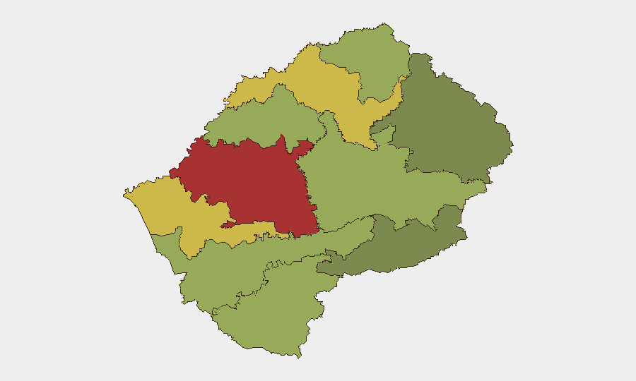
Maseru District (risk score 78) dominates the threat landscape and accounts for a disproportionate share of recorded incidents—driven by urban crime concentration, transactional street crime, armed robbery in informal settlements, and political activity around the capital. Mafeteng (65) and Leribe (62) districts represent secondary risk nodes, typically associated with localized gang activity, inter-communal tension, and limited police presence. The southern and eastern highland districts (Quthing, Qacha's Nek, Mokhotlong) register lower composite scores, reflecting both lower population density and reduced reporting infrastructure; security incidents there may be underestimated. Organizations should treat Maseru as the priority focus for duty-of-care protocols, while maintaining baseline awareness of secondary urban centers.
How GeoBit Would Assist
Security teams operating in Lesotho should deploy AOI Monitoring & Early Warning focused on Maseru, Mafeteng, and Leribe districts to capture emerging crime, protest activity, and political signaling in near-real time. OSINT fusion and multi-language search across local news outlets, social media, and community radio would close reporting gaps and surface incidents before they escalate; entity extraction and network analysis can track key political and criminal actors whose behavior often precedes unrest. GIS & spatial analysis and alternative route/journey planning enable security teams to map safe corridors, identify checkpoints, and adjust staff movement dynamically as conditions shift.
7-Day Outlook
No significant escalation vectors have been identified for the next seven days. Routine crime risk will persist in urban centers; political calendar events (parliamentary activity, local governance matters) should be monitored as potential flashpoints. Organizations are advised to maintain standard duty-of-care protocols, monitor local media and diplomatic channels for any policy shifts, and refresh incident-response procedures quarterly.
Highest-Risk Areas — Ranked
| # | State / Region | Risk |
|---|---|---|
| 1 | Maseru District | 78 |
| 2 | Mafeteng District | 65 |
| 3 | Leribe District | 62 |
| 4 | Berea District | 58 |
| 5 | Mohale's Hoek District | 52 |
| 6 | Butha-Buthe District | 48 |
| 7 | Thaba-Tseka District | 45 |
| 8 | Quthing District | 42 |
| 9 | Mokhotlong District | 38 |
| 10 | Qacha's Nek District | 28 |
Sources
Previous Daily Briefs
A new Lesotho brief is written every day — each with its own risk map and downloadable CSV. Here's the last week; use the calendar to go further back.
- August 22, 2026
- August 20, 2026
- August 18, 2026
- August 15, 2026
- August 13, 2026
- August 11, 2026
- August 9, 2026
📅 Browse every day by calendar →
Highlighted days have a brief. Tap a day for that day's map & analysis, or “csv” for that day's dataset ($5).
Atlas — our AI intelligence desk — emails them this snapshot personally. Nothing else, no list.