Situation Summary
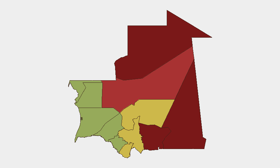
Mauritania remains a lower-tier global security concern (composite threat rank #144), with no tracked security events recorded in the past 48 hours and an overall threat score of 7. However, sub-national risk is highly concentrated in the northeastern and eastern regions—particularly Tiris Zemmour (risk 95) and Hodh Ech Chargui (risk 85)—where cross-border threats, militia activity, and ungoverned space pose persistent challenges to remote operations and supply lines. The capital and coastal regions remain relatively stable, though recent infrastructure failures and organized crime operations underscore vulnerabilities in urban service continuity and law-enforcement capacity.
Key Developments
Verifiable incidents within the 24–48 hour window (25–26 August 2026) are not available from current sources. The most recent reportable developments fall outside the 48-hour constraint:
- Nouakchott-Nord, Nouakchott – 23 August 2026 – Fire at the Est power transformation substation caused electricity outages across multiple districts; presidential intervention and ongoing restoration efforts indicate service disruption risk affecting northern capital operations.
- Nouakchott Ouest, Nouakchott – 22 August 2026 – Major transformer fire at the 33/15 kV station (Somelec infrastructure) triggered emergency response and service loss; pattern suggests aging electrical infrastructure vulnerability in the capital.
- Nouakchott & Nouadhibou – 22 August 2026 (reporting period: July–August 2026) – Police and gendarmerie intensified narcotics and organized-crime operations, including arrest of trafficking suspects, seizure of 6.181 kg of drugs in Nouadhibou, dismantling of drug distribution networks in Nouakchott, and recovery of 427 stolen mobile phones; indicates active law-enforcement response but also underlying urban crime activity.
- Mauritanian EEZ – 21 August 2026 – Coastguard rescued 315 migrants (including 40 children) from an overloaded wooden vessel departing The Gambia; reflects persistent maritime migration pressure and SAR operations load on coastal capacity.
Highest-Risk Areas
Tiris Zemmour (risk 95) and Hodh Ech Chargui (risk 85) dominate the threat landscape, driven by proximity to ungoverned Saharan spaces, historical militia presence, and weak state capacity in remote border zones. Hodh El Gharbi (80) and Adrar (78) extend this eastern and northeastern corridor of elevated risk. By contrast, the capital region and coastal zones (Dakhlet Nouadhibou, Brakna, Trarza) score substantially lower, though recent infrastructure disruptions and organized-crime operations indicate that stability in urban centers cannot be assumed to be permanent. Operations and personnel in Mauritania's interior—particularly those dependent on cross-border supply lines or involving remote project sites—face materially higher exposure than those based in Nouakchott or other coastal commercial hubs.
How GeoBit Would Assist
A security team with personnel or assets in Mauritania would employ AOI Monitoring & Early Warning to track developments in Tiris Zemmour and Hodh Ech Chargui, with persistent alert thresholds for militia activity or cross-border incidents; Intel Sweep and multi-language OSINT (including X/Telegram and regional security forums) to capture incidents and crime reporting outside 24-hour Western news cycles; and GIS & Spatial Analysis combined with Routing & Network Analysis to model alternative supply routes and safe zones during periods of infrastructure failure or unrest. Conflict & Military tracking and Network & Actor Analysis would support assessment of non-state armed groups operating in high-risk regions.
7-Day Outlook
No major escalation is anticipated in the next seven days. However, urban infrastructure fragility (recent electrical failures) and sustained organized-crime activity warrant heightened vigilance in Nouakchott. Personnel should assume continued intermittent service disruptions and exercise standard due diligence regarding petty crime and drug-related enforcement sweeps in coastal and capital zones. Remote eastern operations remain subject to longer-term border and militia risk, independent of near-term trend changes.
Highest-Risk Areas — Ranked
| # | State / Region | Risk |
|---|---|---|
| 1 | Tiris Zemmour | 95 |
| 2 | Hodh Ech Chargui | 85 |
| 3 | Hodh El Gharbi | 80 |
| 4 | Adrar | 78 |
| 5 | Tagant | 68 |
| 6 | Guidimaka | 65 |
| 7 | Assaba | 62 |
| 8 | Gorgol | 58 |
| 9 | Trarza | 55 |
| 10 | Inchiri | 52 |
| 11 | Brakna | 48 |
| 12 | Dakhlet Nouadhibou | 45 |
Sources
Previous Daily Briefs
A new Mauritania brief is written every day — each with its own risk map and downloadable CSV. Here's the last week; use the calendar to go further back.
- August 24, 2026
- August 22, 2026
- August 20, 2026
- August 18, 2026
- August 16, 2026
- August 14, 2026
- August 12, 2026
📅 Browse every day by calendar →
Highlighted days have a brief. Tap a day for that day's map & analysis, or “csv” for that day's dataset ($5).
Atlas — our AI intelligence desk — emails them this snapshot personally. Nothing else, no list.