Situation Summary
Namibia remains a low-threat environment globally (rank #104, composite score 14), with no tracked major security incidents dominating the national picture. However, interpersonal violent crime—particularly fatal stabbings—has surfaced in multiple regions over the past week, concentrated in the north and north-central areas. Northern border regions, especially Zambezi and Kavango East, carry significantly elevated risk profiles and warrant focused monitoring.
Key Developments
- Outapi, Omusati Region | 2026-08-09 (Friday evening): Fatal stabbing during interpersonal conflict; 26-year-old male arrested same day; motive unknown. Victim transported to local care facility.
- Karasburg area, southern Namibia | 2026-08-08: Fatal stabbing during altercation; victim died after transport to Karasburg State Hospital; suspect apprehended and weapon recovered.
- Oshakati/Ondangwa corridor, Oshana Region | 2026-08-07: Fatal stabbing with Okapi knife during interpersonal dispute; suspect arrested and weapon secured.
- Domestic violence incident, location undisclosed | 2026-08-07: Police arrested suspect in alleged attempted murder involving three victims; all victims treated at regional hospital.
- Water treatment facility (location undisclosed) | 2026-08-07: Two Cape Advanced Engineering Namibia employees died following suspected toxic gas exposure during occupational activity; incident classified as workplace disaster, not security-related but affecting foreign workforce.
- Bilateral law enforcement development | 2026-08-07 (Belgrade): Namibia and Serbia signed policing cooperation MoU covering transnational crime, cybercrime, terrorism financing, human trafficking, and money laundering—signals intent to strengthen regional crime-control capacity.
Highest-Risk Areas
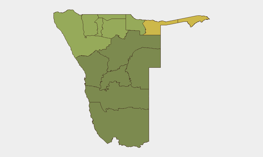
Zambezi Region (risk score 68) and Kavango East (62) dominate the sub-national threat landscape, driven by historical cross-border trafficking, remote governance capacity, and porous boundaries with Angola and Botswana. Kavango West (58) and Kunene Region (52) carry similar dynamics. By contrast, central and southern regions—Hardap (28), Omaheke (25)—remain comparatively stable. Northern and north-central clusters (Oshikoto, Ohangwena, Omusati, Oshana) show moderate-to-elevated risk (40–48), consistent with recent violent-crime signals emerging in those zones.
How GeoBit Would Assist
Security teams would employ Intel Sweep and global event feeds to sustain real-time visibility of violent crime, trafficking, and border incidents across Namibia's twelve regions; AOI Monitoring & Early Warning with persistent watch on Zambezi and Kavango regions to detect escalating patterns or cross-border activity; and GIS & Spatial Analysis to correlate incident clusters (e.g., the recent stabbing concentration) with demographic, economic, and governance data to anticipate hotspots. Alternative Routing & Network Analysis supports safe movement of personnel through or near high-risk zones.
7-Day Outlook
Recent violent-crime incidents appear scattered and interpersonal rather than organized or politically motivated, with no signals of imminent escalation at national level. However, the concentration of stabbings in the north warrants continued close observation to distinguish isolated events from an emerging pattern. The bilateral policing agreement with Serbia may yield intelligence-sharing gains on transnational crime in coming weeks.
Highest-Risk Areas — Ranked
| # | State / Region | Risk |
|---|---|---|
| 1 | Zambezi | 68 |
| 2 | Kavango East | 62 |
| 3 | Kavango West | 58 |
| 4 | Kunene Region | 52 |
| 5 | Oshikoto | 48 |
| 6 | Ohangwena | 45 |
| 7 | Omusati | 42 |
| 8 | Oshana | 40 |
| 9 | Otjozondjupa | 35 |
| 10 | Erongo Region | 32 |
| 11 | Hardap | 28 |
| 12 | Omaheke | 25 |
Sources
Previous Daily Briefs
A new Namibia brief is written every day — each with its own risk map and downloadable CSV. Here's the last week; use the calendar to go further back.
📅 Browse every day by calendar →
Highlighted days have a brief. Tap a day for that day's map & analysis, or “csv” for that day's dataset ($5).
Atlas — our AI intelligence desk — emails them this snapshot personally. Nothing else, no list.