Situation Summary
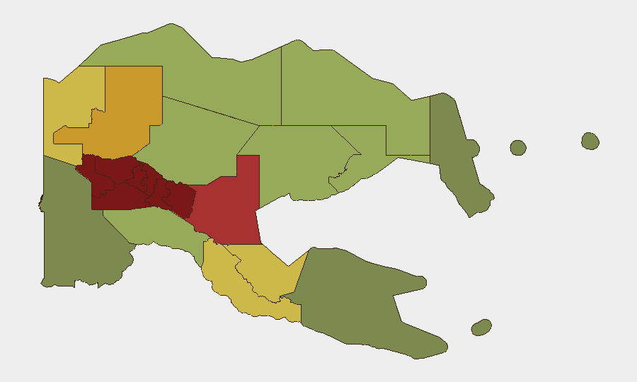
Papua New Guinea remains at a composite global threat rank of #81, with a stable threat score of 21 and no tracked escalations in the past 24 hours. The country's security environment is heavily concentrated in the Highlands region (Southern Highlands, Enga, Hela, Eastern Highlands, and Western Highlands collectively dominate risk rankings with scores 90–98), where tribal violence, inter-community conflict, and limited state presence persist. Recent confirmed incidents point to organized criminal activity and transport-corridor vulnerability alongside ongoing communal violence, though the national security picture has not materially shifted.
Key Developments
- East Sepik Province, Wewak (date unconfirmed, but recent): Boram Airport reported closed following a security breach involving facility damage and theft; flight operations suspended. Exact timing not definitively confirmed within 24–48 hours from available sources.
- Southern Highlands Province (2026-08-10): Police arrested four suspects in connection with the murder of four civilians from Haripmo village; operation ongoing and indicates sustained communal violence in the highest-risk sub-national zone.
- East Sepik Province, transport corridor between Wewak and Maprik (2026-08-10): Two armed men apprehended on a public motor vehicle (PMV); incident demonstrates armed movement and active vulnerability of inter-provincial transport networks.
- Madang Province, urban area (reported 2026-08-09, incidents dated mid-week to early Saturday): Police reported two attacks on government vehicles on the airport road—one bus shot at, another stoned—indicating organized or semi-organized targeting of government transport in urban periphery; timing window does not firmly confirm within 24–48 hours.
- Port Moresby (2026-08-11): Police enforcement action to clear illegal vending at city bus stops; primarily law-and-order operation rather than discrete security incident.
Note: Current 24–48-hour corroboration remains limited. Two events (Haripmo village murders and PMV apprehension) are explicitly dated 2026-08-10 and fall within the window; the Boram Airport and Madang incidents are recent but lack precise timestamping.
Highest-Risk Areas
The five Highlands provinces—Southern Highlands, Enga, Hela, Eastern Highlands, and Western Highlands—account for the most acute risk, with composite scores ranging from 90 to 98. This concentration reflects endemic tribal and inter-community conflict, limited police and state presence, and a history of armed group activity and weapons proliferation in remote, difficult-to-access terrain. Southern Highlands (risk 98) and Enga (risk 96) are the most severe; the National Capital District (risk 85), despite being the capital and administrative hub, ranks seventh and reflects both port and urban crime pressure. Organizations with personnel or operations in the Highlands should treat these zones as requiring continuous situational monitoring and heightened duty-of-care protocols.
How GeoBit Would Assist
Organizations operating in Papua New Guinea should deploy AOI Monitoring & Early Warning on high-risk sub-national zones (especially Southern Highlands, Enga, and Hela) to detect emerging violence or group movement in near-real-time. Routing & Network Analysis and Maritime & Aviation tracking can identify safe and alternative transport corridors and verify facility status (as with Boram Airport). OSINT Fusion & Corroboration (including X/Telegram feeds, multi-language search, and sentiment analysis) will improve visibility on sub-national incidents that may not reach mainstream news within 24–48 hours.
7-Day Outlook
No immediate escalation is anticipated, but the Highlands remain in a persistent state of low-intensity communal and criminal violence; seasonal and tribal calendars should be monitored for organized events or ceremonies that historically trigger conflict. Transport-corridor security (road and air) should remain under active watch given recent armed apprehensions and airport closure signals. Corporate teams should maintain regular contact with local security liaisons and police counterparts to confirm real-time status of critical facilities and routes.
Highest-Risk Areas — Ranked
| # | State / Region | Risk |
|---|---|---|
| 1 | Southern Highlands | 98 |
| 2 | Enga | 96 |
| 3 | Hela | 94 |
| 4 | Eastern Highlands | 92 |
| 5 | Western Highlands | 90 |
| 6 | Jiwaka | 88 |
| 7 | National Capital District | 85 |
| 8 | Simbu | 82 |
| 9 | Morobe | 78 |
| 10 | East Sepik | 72 |
| 11 | Sandaun | 68 |
| 12 | Oro | 66 |
Sources
Previous Daily Briefs
A new Papua New Guinea brief is written every day — each with its own risk map and downloadable CSV. Here's the last week; use the calendar to go further back.
📅 Browse every day by calendar →
Highlighted days have a brief. Tap a day for that day's map & analysis, or “csv” for that day's dataset ($5).
Atlas — our AI intelligence desk — emails them this snapshot personally. Nothing else, no list.