Situation Summary
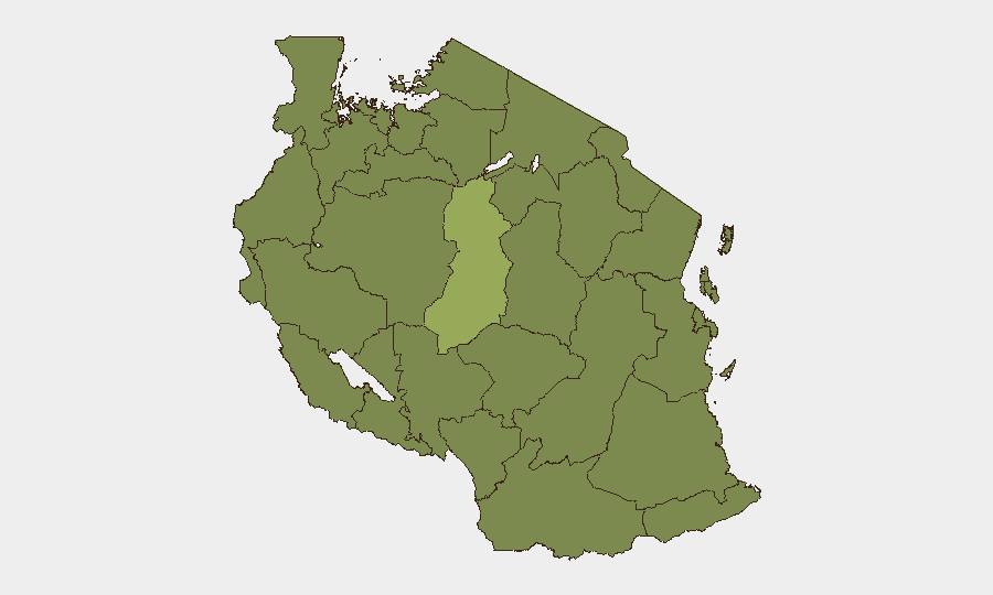
Tanzania remains at composite threat rank #48 globally with a moderate security score of 37, reflecting an environment characterized by localized governance tensions and periodic unrest rather than widespread instability. The country's risk profile is heavily concentrated in Singida Region (score 55.9), which significantly outpaces all other administrative divisions; the remaining 11 highest-risk regions cluster at 25.9, indicating a geographically fragmented threat landscape. As of 15 July 2026, no clearly verified new security, crime, or infrastructure incidents meeting cross-source confirmation standards have been documented in the preceding 24–48 hours; the current baseline remains defined by events from early July.
Key Developments
No new security incidents in Tanzania have been independently verified and cross-confirmed within the last 24–48 hours (13–15 July 2026) through available open-web, social-media, and independent news sources. GeoBit's monitoring protocols require multi-source corroboration for incident inclusion; events from 7–8 July and earlier, while part of the recent risk environment, fall outside the strict recency window for this brief.
Background context (not current): Early July incidents, including Saba Saba Day (7 July) protest management and related law-enforcement activity, formed the most recent documented events; these predate the 24–48-hour window but remain relevant to understanding the current operational environment.
Highest-Risk Areas
Singida Region stands apart with a composite risk score of 55.9—more than double the risk level of all other tracked regions—and represents the primary geographic concentration of monitored threat activity in Tanzania. The remaining 11 highest-risk administrative divisions (Kigoma, Kagera, Mwanza, Geita, Shinyanga, Tabora, Katavi, Rukwa, Songwe, Mara, and Simiyu) register identical scores of 25.9, suggesting either distributed lower-level threats or monitoring saturation effects across western and southwestern Tanzania. Organizations with personnel or assets in Singida should maintain heightened situational awareness; those operating in the secondary risk band should apply standard country-level precautions. The concentration of risk in these regions reflects historical patterns of resource-sector activity, pastoral community tensions, and periodic cross-border movement rather than active acute crises.
How GeoBit Would Assist
Security teams protecting people and assets in Tanzania should leverage AOI (Area-of-Interest) Monitoring & Early Warning for Singida Region and secondary risk zones, with persistent satellite and OSINT surveillance configured to alert on protest activity, law-enforcement operations, or cross-border movement. Intel Sweep, X/Twitter OSINT, and multi-source event feed fusion provide real-time detection of emerging unrest, administrative policy changes, or sectoral disruptions; teams can configure temporal and sentiment analysis to distinguish routine governance announcements from escalatory signals. For route planning and asset mobility, Routing & Network Analysis enables identification of secure transit corridors avoiding highest-risk zones, particularly in Singida.
7-Day Outlook
No acute escalation drivers are evident in the immediate 7-day window (15–22 July 2026); the threat environment is expected to remain at current baseline levels absent new triggering events. Continued monitoring of Singida Region is warranted; standard regional vigilance should apply elsewhere. Organizations should maintain brief-refresh cadence at 48-hour intervals and configure alert thresholds to capture any verified incident in priority areas.
Highest-Risk Areas — Ranked
| # | State / Region | Risk |
|---|---|---|
| 1 | Singida Region | 55.9 |
| 2 | Kigoma Region | 25.9 |
| 3 | Kagera | 25.9 |
| 4 | Mwanza Region | 25.9 |
| 5 | Geita | 25.9 |
| 6 | Shinyanga Region | 25.9 |
| 7 | Tabora Region | 25.9 |
| 8 | Katavi Region | 25.9 |
| 9 | Rukwa Region | 25.9 |
| 10 | Songwe Region | 25.9 |
| 11 | Mara Region | 25.9 |
| 12 | Simiyu | 25.9 |
Sources
Previous Daily Briefs
A new Tanzania brief is written every day — each with its own risk map and downloadable CSV. Here's the last week; use the calendar to go further back.
📅 Browse every day by calendar →
Highlighted days have a brief. Tap a day for that day's map & analysis, or “csv” for that day's dataset ($5).
Atlas — our AI intelligence desk — emails them this snapshot personally. Nothing else, no list.