Situation Summary
Ukraine remains the second-highest-threat environment globally, with 1,881 tracked security events and a composite threat score of 100. Large-scale Russian missile and drone strikes on civilian infrastructure continue across multiple regions, with particular intensity in and around Kyiv; simultaneous Ukrainian long-range drone operations into Russian territory are generating retaliatory cycles. The conflict trajectory shows no de-escalation signal, with air-raid risks, civilian casualties, and infrastructure damage sustained at high levels.
Key Developments
- Kyiv, 2 July 2026: Russia conducted one of the year's largest aerial assaults on the capital, deploying approximately 74 missiles and 496 drones. Ukrainian air defense intercepted the majority, but at least 30 civilians were killed, 91 injured, and over 130 buildings destroyed or damaged. Kyiv observed an official day of mourning on 3 July with continued air-raid warnings.
- Sumy Oblast, overnight 2–3 July 2026: Russian drone strike on a residential house killed four civilians (two women, one elderly man, one girl under two) and injured at least three others, according to regional military administration reports.
- Kryvyi Rih, Dnipropetrovsk Oblast, night of 2–3 July 2026: Russian attacks caused multiple civilian injuries in strikes on residential areas; emergency services responded to damaged infrastructure across the city.
- Multiple regions, overnight 3 July 2026: Wave of Russian attacks across several oblasts (including Sumy and Kryvyi Rih noted above) resulted in at least four killed and 10 injured; air-raid alerts and drone/missile interceptions were widespread.
- Moscow and Russian territory, 1–2 July 2026: Ukraine conducted large-scale long-range drone operations targeting Russian military and energy infrastructure, with Russian authorities claiming over 400 drones intercepted. Ukrainian officials characterized the strikes as economic pressure, but they typically precede Russian retaliatory attacks on Ukrainian civilian targets.
- Crimea, 2–3 July 2026: Ukrainian drone strikes contributed to fuel shortages and power cuts in occupied territory, compounding infrastructure disruption and prompting Russian security tightening and movement controls.
- U.S. legislation advance, 2 July 2026: Bipartisan U.S. lawmakers moved legislation to allow seized Russian sovereign assets to fund Ukrainian defense purchases, with potential implications for the scale and duration of military operations and thus medium-term security conditions in Ukraine.
Highest-Risk Areas
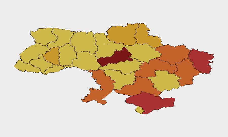
Kyiv (risk 100) dominates the threat landscape due to its scale, infrastructure density, and status as a primary Russian targeting priority; the 2 July strike demonstrated sustained Russian capability to inflict mass civilian casualties. Cherkasy Oblast (96.9) and Luhansk Oblast (78.6) follow, with Cherkasy showing emerging risk concentration. The central and eastern oblasts—Kharkiv, Dnipropetrovsk, Donetsk, and Sumy—cluster in the 72–75 range, reflecting active front-line proximity, drone saturation, and critical infrastructure vulnerability. Occupied Crimea and southern Odesa/Kherson remain under dual conventional and drone-strike risk.
How GeoBit Would Assist
Corporate security teams should deploy AOI Monitoring & Early Warning on priority facilities in Kyiv, Cherkasy, and Dnipropetrovsk Oblast to detect air-raid alerts and strike patterns in near real-time. Conflict & Military tracking (battle mapping, weapons-capability analysis) and Intel Sweep (multi-language OSINT fusion from Telegram, X, Ukrainian military statements) enable 24–48-hour tactical situational awareness ahead of strike waves. Routing & Network Analysis supports alternate travel and supply-chain planning for personnel and assets in high-risk zones.
7-Day Outlook
Russian air operations are likely to sustain elevated tempo in response to Ukrainian long-range drone strikes; Kyiv, Cherkasy, and major cities in central and eastern Ukraine should anticipate repeat large-scale missile and drone waves. Infrastructure damage and civilian disruption will continue to constrain movement and operations. No imminent political settlement signals exist; duty-of-care posture should remain at heightened alert through mid-July.
Highest-Risk Areas — Ranked
| # | State / Region | Risk |
|---|---|---|
| 1 | Kyiv | 100 |
| 2 | Cherkasy Oblast | 96.9 |
| 3 | Luhansk Oblast | 78.6 |
| 4 | Autonomous Republic of Crimea | 78.3 |
| 5 | Kharkiv Oblast | 74.9 |
| 6 | Dnipropetrovsk Oblast | 73.7 |
| 7 | Donetsk Oblast | 73.7 |
| 8 | Odesa Oblast | 73.1 |
| 9 | Kherson Oblast | 73 |
| 10 | Chernihiv Oblast | 72.5 |
| 11 | Sumy Oblast | 72.4 |
| 12 | Ternopil Oblast | 71.9 |
Sources
Previous Daily Briefs
A new Ukraine brief is written every day — each with its own risk map and downloadable CSV. Here's the last week; use the calendar to go further back.
📅 Browse every day by calendar →
Highlighted days have a brief. Tap a day for that day's map & analysis, or “csv” for that day's dataset ($5).