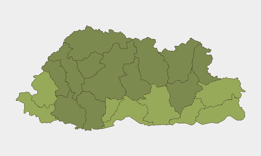
Situation Summary
Bhutan remains a very low-threat operating environment with no verified security incidents, civil unrest, crime surges, or infrastructure disruptions reported in the last 24–48 hours. The national composite threat score is 3 (globally ranked #null), and domestic media and open-source monitoring confirm an absence of acute incidents. Border tension is present at Runikhata Forest Range Office on the India–Bhutan border in Assam's Chirang district (28–29 July), but all reporting indicates the violent protest and police response remain on the Indian side, with no confirmed spillover into Bhutanese territory.
Key Developments
- India–Bhutan Border, Chirang District, Assam (28–29 July): Violent protest with police opening fire and vehicle arson reported at Runikhata Forest Range Office on the Indian side of the border. No confirmed incidents or spillover inside Bhutan reported; however, the proximity warrants monitoring for cross-border impact on adjacent Bhutanese districts.
- National Domestic Media (28–29 July): Bhutan Broadcasting Service reports focus on waste management issues in Gangtey–Phobji and municipal election matters in Phuentshokling (water, development, disaster management). No reports of fresh crime, civil unrest, attacks, or infrastructure failures.
- **Network Connectivity (18–19 July – *outside current window*): A telecom disruption affecting parts of Bhutan was reported 18–19 July; this is not within the current 24–48-hour window and is not an active development**.
- **Crime Trend (first half 2026 – *aggregate reporting, not incident-specific*):** Bhutan Broadcasting Service notes a slight overall increase in crime cases in H1 2026 and a decline in drug offences; this is a six-month aggregate trend, not a discrete current event.
Highest-Risk Areas
Samtse, Sarpang, and Haa districts carry the highest sub-national composite risk scores (58, 55, and 52 respectively), driven by proximity to international borders and cross-border dynamics; Samtse and Sarpang adjoin India's Assam state, where the Runikhata incident underscores ongoing border-zone tension. Lower-risk central and northern districts (Gasa, Lhuntse, Wangdue Phodrang) reflect reduced cross-border exposure and more stable domestic conditions. The southern tier warrants elevated monitoring given its adjacency to Indian territory and the recent Chirang-district violence.
How GeoBit Would Assist
Teams operating in or with assets in Bhutan should employ AOI (Area-of-Interest) Monitoring & Early Warning focused on the southern border districts—particularly Samtse and Sarpang—to detect any cross-border spillover or escalation at the India–Bhutan frontier. Intel Sweep, multi-language search, and X/Twitter OSINT provide continuous monitoring of domestic media, civil society communications, and incident reporting to flag emerging civil unrest, crime patterns, or infrastructure disruption ahead of operational impact. Routing & Network Analysis supports contingency planning for operations in high-risk southern districts should border tension intensify.
7-Day Outlook
No acute threat triggers are visible in Bhutan's domestic environment over the next 7 days. Border tension at Runikhata remains an external variable; continued escalation on the Indian side could prompt secondary effects (refugee movement, cross-border security responses, or commercial disruption), but current reporting indicates no imminent spillover. Routine monitoring of southern districts and border-zone dynamics is warranted; the overall threat trajectory for Bhutan remains stable and very low.
Highest-Risk Areas — Ranked
| # | State / Region | Risk |
|---|---|---|
| 1 | Samtse District | 58 |
| 2 | Sarpang District | 55 |
| 3 | Haa District | 52 |
| 4 | Pemagatshel District | 50 |
| 5 | Samdrup Jongkhar District | 48 |
| 6 | Tsirang District | 45 |
| 7 | Zhemgang District | 42 |
| 8 | Trashigang District | 40 |
| 9 | Mongar District | 38 |
| 10 | Gasa District | 35 |
| 11 | Lhuntse District | 32 |
| 12 | Wangdue Phodrang District | 30 |
Sources
Previous Daily Briefs
A new Bhutan brief is written every day — each with its own risk map and downloadable CSV. Here's the last week; use the calendar to go further back.
📅 Browse every day by calendar →
Highlighted days have a brief. Tap a day for that day's map & analysis, or “csv” for that day's dataset ($5).
Atlas — our AI intelligence desk — emails them this snapshot personally. Nothing else, no list.