Situation Summary
East Timor remains a low-threat environment globally (rank #175, composite score 3.0) with no tracked security incidents in the past 24–48 hours. The country's security posture has been bolstered by recent law-enforcement action against transnational crime, particularly online fraud networks. Regional cooperation mechanisms with Indonesia and Australia are active, and cybersecurity governance is being formalized at the national level. The overall trajectory is stable, though sub-national risk concentration in the capital and western districts warrants continued duty-of-care attention.
Key Developments
- No new security incidents confirmed in the past 24–48 hours as of 2026-08-12. Available open-source reporting does not yield genuine events outside the 6–8 August window.
- Dili & Liquiçá (5–6 August): Police concluded a five-week anti-fraud campaign (26 June–5 August) dismantling 16 scam facilities and detaining 357 foreign nationals, signaling sustained law-enforcement focus on cybercrime networks operating in the capital and western Liquiçá district.
- Border-security cooperation (6 August): Indonesia, Australia, and Timor-Leste reinforced trilateral coordination on transnational crime and intelligence sharing at the sub-regional level, indicating strengthened institutional capacity to detect and intercept cross-border criminal activity.
- Cybersecurity governance (6–8 August): Timor-Leste's government established an interministerial cybersecurity committee, reflecting institutional steps to centralize cyber-threat policy and likely improve incident reporting and coordination.
Highest-Risk Areas
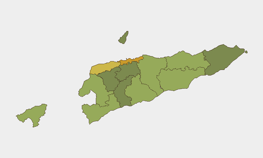
Dili (risk 72) and Liquiçá (risk 62) account for the largest concentration of measured sub-national risk, driven primarily by urbanization, transnational criminal infrastructure (online fraud networks), and cross-border exposure. Baucau (58) and Cova Lima (55) in the eastern and southern periphery show elevated scores, likely reflecting lower state capacity and proximity to maritime trafficking routes. Oecussi-Ambeno (48), an enclave bordered by Indonesia, carries persistent border-management risk. Risk decreases significantly in the central highlands and eastern rural districts, where population density and criminal infrastructure are lower. For duty-of-care purposes, personnel and assets in Dili, Liquiçá, and Baucau warrant elevated monitoring and contingency planning.
How GeoBit Would Assist
Security teams should deploy AOI Monitoring & Early Warning on Dili, Liquiçá, and Baucau to establish persistent watch for emerging crime or instability signals, with alert thresholds calibrated to staff movement and asset location. Intel Sweep and OSINT fusion (X/Twitter, Telegram, local media, law-enforcement reporting) would provide real-time event corroboration and sentiment tracking to fill gaps in formal reporting. Entity extraction and network analysis would map transnational crime actors and infrastructure, supporting vetting and travel-risk assessment for personnel transiting high-risk districts or working with local partners.
7-Day Outlook
No acute security escalation is forecast over the next seven days. Law-enforcement momentum against organized fraud networks is likely to sustain, with possible additional facility closures and arrests. Regional cooperation frameworks should continue to tighten, reducing immediate cross-border criminal opportunity. Operational security and standard duty-of-care protocols remain sufficient for most corporate activity; heightened vigilance in Dili and Liquiçá during evening hours and in unlit peripheral areas is prudent.
Highest-Risk Areas — Ranked
| # | State / Region | Risk |
|---|---|---|
| 1 | Dili | 72 |
| 2 | Liquiçá | 62 |
| 3 | Baucau | 58 |
| 4 | Cova Lima | 55 |
| 5 | Bobonaro | 53 |
| 6 | Oecussi-Ambeno | 48 |
| 7 | Manufahi | 45 |
| 8 | Viqueque | 42 |
| 9 | Manatuto | 40 |
| 10 | Ainaro | 38 |
| 11 | Ermera | 36 |
| 12 | Aileu | 32 |
Sources
Previous Daily Briefs
A new East Timor brief is written every day — each with its own risk map and downloadable CSV. Here's the last week; use the calendar to go further back.
📅 Browse every day by calendar →
Highlighted days have a brief. Tap a day for that day's map & analysis, or “csv” for that day's dataset ($5).
Atlas — our AI intelligence desk — emails them this snapshot personally. Nothing else, no list.