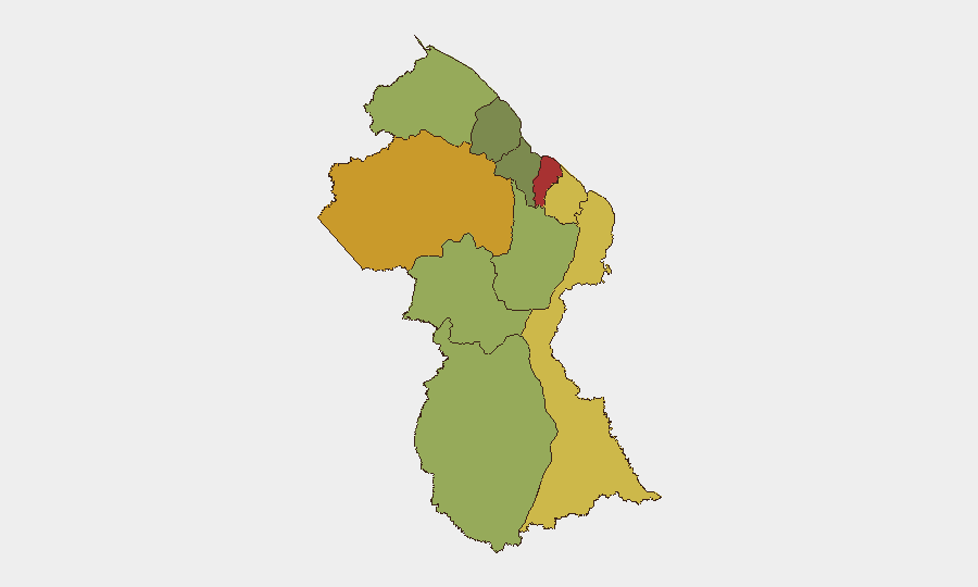
Situation Summary
Guyana remains a moderate-risk environment (global rank #105) with fragmented but persistent violent crime concentrated in coastal urban areas and remote mining/interior zones. Over the past 72 hours, the country has registered at least four significant violent incidents—armed robbery, fatal altercations, and a suspicious death—alongside fatal transport accidents, indicating sustained baseline violence rather than acute escalation. No tracked events meet the threshold for national-level instability, but localized security pressures in Demerara-Mahaica and interior mining regions remain operationally relevant for corporate personnel and asset movement.
Key Developments
- 14 Miles Issano Landing, Middle Mazaruni River – Armed Robbery (13 August, ~03:00 hrs): Two armed miners robbed a 30-year-old gold miner at a riverside shop, discharged multiple handgun rounds, and stole approximately GY$130,000. Police arrested three suspects and recovered a Glock pistol. *Significance:* Demonstrates persistent firearm availability and violence in remote mining zones; indicates limited enforcement capacity in interior areas.
- Ogle Road, East Coast Demerara – Suspicious Death (discovered 11 August, reported through 16 August): A 33-year-old businessman found dead in a parked vehicle with apparent gunshot wound to chest; circumstances under investigation. *Significance:* Urban-area fatality; unclear whether homicide, suicide, or accident; highlights security concerns in East Coast Demerara.
- Linden–Soesdyke Highway, Loo Creek – Fatal Road Collision (15 August, evening): Three-vehicle collision resulted in one fatality (chef). *Significance:* Highway corridor remains high-risk for transport; relevant to personnel mobility planning.
- Pomeroon River, Region Two – Boat Collision Fatality (16 August): 28-year-old miner died following collision with vessel operated by 11-year-old. *Significance:* River-transport safety; suggests oversight and enforcement gaps in interior waterway traffic.
- Amerindian People's Association Picket Line (13 August): Protest demanding removal of Minister of Public Works and Public Utilities and Aviation. *Significance:* Low-intensity labor/political friction; no disruption reported, but signals ongoing governance grievances.
Highest-Risk Areas
Demerara-Mahaica (risk score 78) and Cuyuni-Mazaruni (72) drive national exposure, reflecting concentrated violent crime in Georgetown and surrounding urban zones, combined with lawlessness in remote gold-mining areas. East Berbice-Corentyne, Mahaica-Berbice, and Upper Demerara-Berbice collectively account for middle-tier risk driven by isolation, weak state presence, and transactional violence (robbery, trafficking). Interior regions—Potaro-Siparuni, Barima-Waini—face mining-sector instability and limited law enforcement; coastal and island regions (Essequibo Islands, Pomeroon-Supenaam) show lower absolute scores but remain vulnerable to localized incidents due to geographic isolation and enforcement gaps.
How GeoBit Would Assist
Intel Sweep, X/Twitter & Telegram OSINT, and multi-language search enable real-time tracking of emerging violent incidents, protest activity, and enforcement responses across Guyanese news outlets and social media—critical for 24–48-hour alerting. AOI Monitoring & Early Warning with persistent watch over Demerara-Mahaica, mining corridors (Cuyuni-Mazaruni), and key transport routes (Linden–Soesdyke Highway, Pomeroon River) provides automated escalation notification. Routing & Network Analysis supports alternative route and safe-corridor planning for personnel movement, factoring real-time crime and transport incidents.
7-Day Outlook
No acute political, infrastructure, or security shock is anticipated. Baseline violent crime and transport accidents are expected to persist at current low-to-moderate tempo. Risk to corporate personnel remains localized and manageable with standard duty-of-care measures; however, interior mining zones and late-night urban movement warrant elevated vigilance and pre-planned avoidance protocols.
Highest-Risk Areas — Ranked
| # | State / Region | Risk |
|---|---|---|
| 1 | Demerara-Mahaica | 78 |
| 2 | Cuyuni-Mazaruni | 72 |
| 3 | Mahaica-Berbice | 65 |
| 4 | East Berbice-Corentyne | 62 |
| 5 | Upper Demerara-Berbice | 58 |
| 6 | Potaro-Siparuni | 48 |
| 7 | Barima-Waini | 45 |
| 8 | Upper Takutu-Upper Essequibo | 42 |
| 9 | Pomeroon-Supenaam | 38 |
| 10 | Essequibo Islands | 35 |
Sources
Previous Daily Briefs
A new Guyana brief is written every day — each with its own risk map and downloadable CSV. Here's the last week; use the calendar to go further back.
- August 15, 2026
- August 13, 2026
- August 11, 2026
- August 9, 2026
- August 7, 2026
- August 6, 2026
- August 5, 2026
📅 Browse every day by calendar →
Highlighted days have a brief. Tap a day for that day's map & analysis, or “csv” for that day's dataset ($5).
Atlas — our AI intelligence desk — emails them this snapshot personally. Nothing else, no list.