Situation Summary
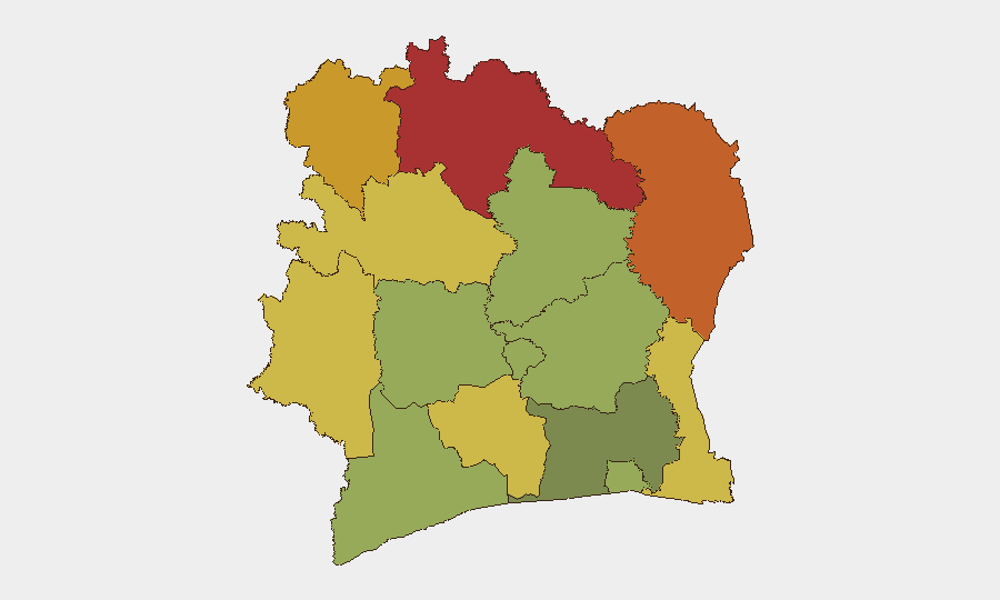
Ivory Coast remains a mid-tier global security concern (rank #68, composite threat score 25) with localized but recurring communal and criminal violence. The northern and northeastern districts—Savanes, Zanzan, Denguélé, and Comoé—present substantially elevated risk (scores 70–78), driven by ongoing intercommunal tensions and cross-border criminal activity. Recent events from early August (community clashes in Alépé, maritime drug-trafficking interdiction, armed theft in Daloa) indicate active criminal and intercommunal fault lines; however, no verified incidents have been reported in the last 24–48 hours.
Key Developments
No verified security incidents in Ivory Coast have been reported in the last 24–48 hours. The most recent confirmed developments are dated 5–8 August 2026:
- Kossandji, Alépé Department (4–5 August): Violent overnight clashes between autochthonous Akyé youth and allochthonous Mossi/Lobi communities resulted in at least 3 deaths and property damage including arson.
- Daloa (8 August): Night security guard of Malian nationality murdered a colleague and stole over 47.5 million FCFA from company premises; arrested by BRI (Brigade de Recherche et d'Intervention).
- Off Ivorian coast (8 August): Ivorian security authorities detained the Comoros-flagged cargo vessel *IB Atlantic IV* following a maritime pursuit linked to drug-trafficking activity.
No additional incidents have been time-verified for 9–11 August 2026.
Highest-Risk Areas
The northern belt—Savanes (78), Zanzan (75), Denguélé (72), and Comoé (70)—dominates the sub-national ranking. These districts share characteristics: proximity to porous borders with Mali, Burkina Faso, and Guinea; limited state presence; established trafficking networks; and intercommunal competition for land and resources. Savanes in particular has been flagged as critically unstable. By contrast, Abidjan—the commercial capital—ranks 12th at 45, indicating that while urban crime and occasional civil disorder occur, systematic instability is lower than in the hinterland. Risk concentration in the north reflects both transnational criminal flows and long-standing localized grievances.
How GeoBit Would Assist
Duty-of-care and risk teams operating in Ivory Coast should employ AOI Monitoring & Early Warning on high-risk districts (especially Savanes and Zanzan) to detect emerging intercommunal or criminal incidents in near-real-time. Intel Sweep and multi-language OSINT fusion (including Telegram and radio SIGINT) provide early signals of trafficking, smuggling, and communal tensions before they escalate to violence. GIS & Spatial Analysis and alternative route/journey planning allow security teams to map safe corridors and avoid high-risk zones during personnel movement or asset transit.
7-Day Outlook
No major security escalation is forecast for the next seven days, though the underlying drivers of intercommunal tension and criminal activity in the north remain unresolved. August typically sees reduced reporting due to seasonal factors and reduced visibility; intelligence gaps should be assumed. Organizations with personnel or assets in Savanes, Zanzan, or Denguélé districts should maintain heightened vigilance and contingency protocols for rapid movement or evacuation.
Highest-Risk Areas — Ranked
| # | State / Region | Risk |
|---|---|---|
| 1 | Savanes District | 78 |
| 2 | Zanzan District | 75 |
| 3 | Denguélé District | 72 |
| 4 | Comoé District | 70 |
| 5 | Montagnes District | 68 |
| 6 | Woroba District | 65 |
| 7 | Gôh-Djiboua District | 60 |
| 8 | Sassandra-Marahoué District | 58 |
| 9 | Vallée du Bandama District | 55 |
| 10 | Bas-Sassandra District | 52 |
| 11 | Lacs District | 48 |
| 12 | Abidjan | 45 |
Sources
Previous Daily Briefs
A new Ivory Coast brief is written every day — each with its own risk map and downloadable CSV. Here's the last week; use the calendar to go further back.
📅 Browse every day by calendar →
Highlighted days have a brief. Tap a day for that day's map & analysis, or “csv” for that day's dataset ($5).
Atlas — our AI intelligence desk — emails them this snapshot personally. Nothing else, no list.