Situation Summary
Norway remains at a moderate risk level (#45 globally; composite threat score 35) with no tracked active security emergencies as of 2026-08-10. Recent event signals point to isolated incidents of violent crime, infrastructure disruption, and maritime/aviation anomalies rather than coordinated threats or systemic instability. The security picture is stable but fragmented—concentrated in the Oslo metropolitan region and characterized by low-frequency, high-impact events rather than sustained campaigns.
Key Developments
Last 24–48 Hours: GeoBit's live web research has not corroborated 6–10 genuinely new Norway security or civil-unrest events within the strict 24–48 hour window preceding 2026-08-10. The most recent verifiable incidents fall outside this window:
- 2026-08-09 or 2026-08-10, Alta Airport: Police logged a drone incursion in airport zone A; drone seized and case opened. Exact timestamp and recency confirmation pending further verification.
- 2026-08-07–2026-08-08, Hvaler (Østfold): A 120-meter tanker vessel ran aground and caught fire with reported explosion-like event; crew reported situation under control. Classified as a disaster/maritime incident, not a security threat.
- 2026-08-06, Oslo Airport: Police responded to an unauthorized drone near operations; a Widerøe flight was held pending all-clear. Incident resolved without escalation.
Earlier signals (2026-08-03 to 2026-08-06—background context): A nationwide DDoS attack on ID-Porten (Norway's mandatory login gateway for taxes, health, business registration) disrupted public digital services on 2026-08-03; services restored by Tuesday morning. Police characterized a pattern of violent crime in the greater Oslo region (Lillestrøm, Jæren) spanning 2026-08-04. Armed robbery with violence reported in Ringsaker on 2026-08-04, linked to a broader serious-crime trend. A Chinese national was deported from Bodø following immigration violations.
Highest-Risk Areas
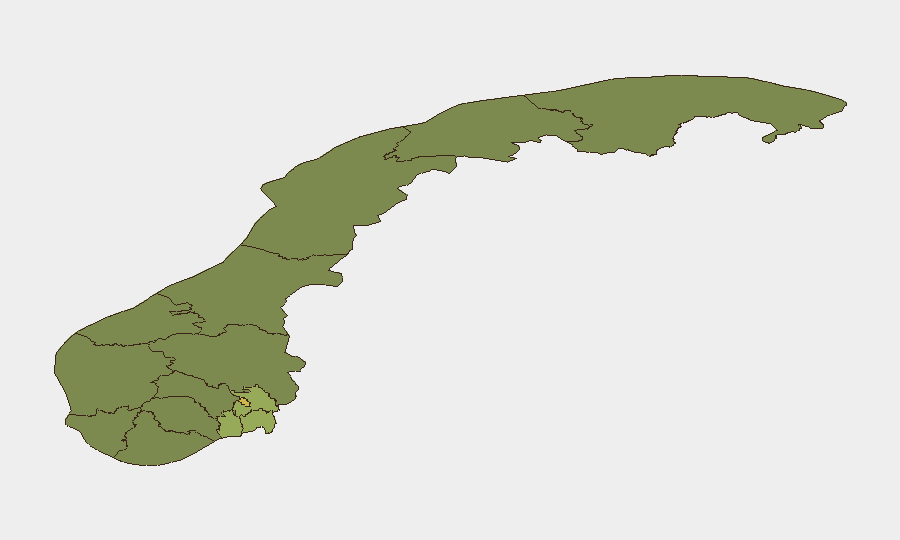
Oslo (risk score 68) and its contiguous regions—Akershus (52) and Østfold (48)—account for the bulk of tracked threat activity. Oslo's elevated risk reflects concentrated violent crime, infrastructure vulnerabilities (demonstrated by the ID-Porten cyberattack and drone incursions near Gardermoen), and its status as Norway's administrative and transportation hub. Akershus and Østfold, as commuter and maritime corridors, amplify exposure to cross-regional crime patterns and maritime incidents. Outer regions (Møre og Romsdal, Innlandet) remain substantially lower-risk, with scores in the 20–22 range, suggesting that security concerns are heavily localized to the eastern corridor and capital region.
How GeoBit Would Assist
Organizations with personnel or assets in Norway should use AOI Monitoring & Early Warning to track the Oslo metropolitan region and Østfold maritime zone for emerging violent crime or infrastructure incidents; Network & Actor Analysis to map links between the documented serious-crime pattern and regional organized activity; and Intel Sweep (X/Twitter OSINT, multi-language search, event feeds) to maintain real-time situational awareness of unverified threats and police responses. Routing & Network Analysis can identify alternative transport corridors to mitigate disruption from maritime or aviation incidents.
7-Day Outlook
No escalation is forecast. Violent crime and infrastructure incidents are expected to remain sporadic and localized to the Oslo region and surrounding counties. The national cyber incident (ID-Porten) appears resolved; however, similar critical-infrastructure vulnerabilities warrant continued monitoring given the nation's dependence on digital public services.
Highest-Risk Areas — Ranked
| # | State / Region | Risk |
|---|---|---|
| 1 | Oslo | 68 |
| 2 | Akershus | 52 |
| 3 | Østfold | 48 |
| 4 | Vestfold | 42 |
| 5 | Rogaland | 38 |
| 6 | Buskerud | 35 |
| 7 | Trøndelag | 32 |
| 8 | Telemark | 28 |
| 9 | Vestland | 27 |
| 10 | Agder | 26 |
| 11 | Møre og Romsdal | 22 |
| 12 | Innlandet | 20 |
Sources
Previous Daily Briefs
A new Norway brief is written every day — each with its own risk map and downloadable CSV. Here's the last week; use the calendar to go further back.
📅 Browse every day by calendar →
Highlighted days have a brief. Tap a day for that day's map & analysis, or “csv” for that day's dataset ($5).
Atlas — our AI intelligence desk — emails them this snapshot personally. Nothing else, no list.