Situation Summary
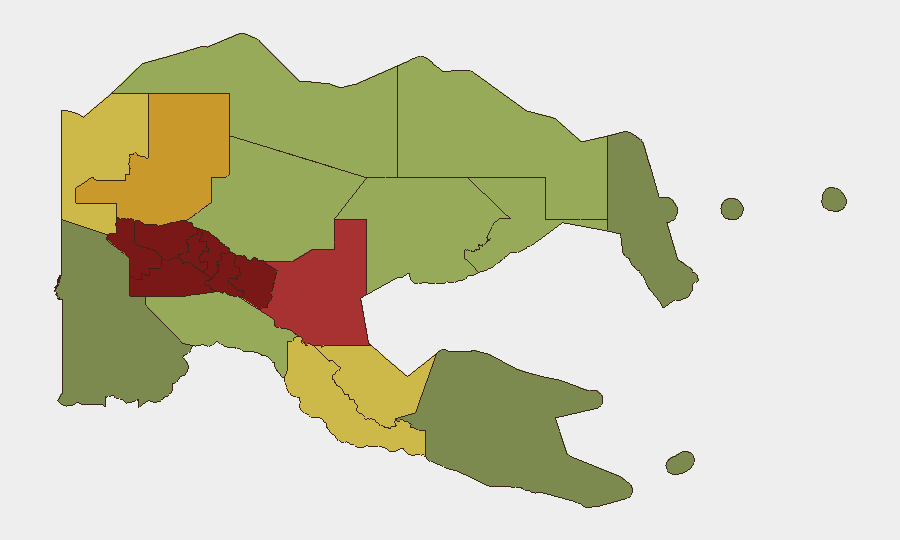
Papua New Guinea remains at moderate global threat rank (#81, composite score 21) with fragmented but persistent violence concentrated in the Highlands provinces and the National Capital District. The last 48 hours have seen no major escalations, but ongoing tribal conflict, armed robbery, and civilian targeting continue to drive elevated risk in Southern Highlands, Enga, Hela, and Eastern Highlands—all scoring above 90. The security environment reflects chronic intercommunal violence, state capacity gaps, and opportunistic armed crime rather than a sudden deterioration.
Key Developments
- Port Moresby, 14 Aug 2026 — Water PNG initiated a major pipeline repair affecting citywide supply; water rationing and disruption expected to persist 2–3 days, potentially straining essential services and complicating emergency response logistics.
- Enga Province, 14 Aug 2026 — UK travel advisory reiterated heightened risk status following intercommunal violence, with active checkpoints, random searches, curfews, and reported deaths and property destruction in large parts of the province.
- Hela Province, 14 Aug 2026 — Travel advisory maintained "all but essential travel" warning due to persistent tribal-fighting risk; no new incidents reported but advisory reflects sustained threat.
- Southern Highlands Province, 14 Aug 2026 — Similar advisory stance; tribal-fighting risk remains the primary driver of the province's #1 sub-national risk ranking (score 98).
- Event background (past 5 days) — Since 8 Aug, Port Moresby experienced a 14-person armed public clash (8 Aug); Baliem Valley Cultural Festival shooting injured two civilians (9 Aug, trigger unknown); Madang airport road saw two separate attacks on government vehicles including a bus shooting and stoning (9 Aug); Haripmo village murder of four civilians resulted in four arrests (10 Aug); inter-provincial armed robbery on Wewak–Maprik motor vehicle (10 Aug).
Highest-Risk Areas
Southern Highlands, Enga, Hela, and Eastern Highlands provinces form a Highlands corridor with composite risk scores of 92–98, driven primarily by endemic tribal and intercommunal fighting, inadequate state policing, and limited rule-of-law enforcement. The National Capital District (rank 7, score 85) remains a secondary concern due to armed street crime, robberies, and sporadic gang violence. Western Highlands and Jiwaka complete the top-tier risk belt. Risk in these zones stems from historical grievances, land disputes, access to improvised weapons, and weak state capacity to mediate or contain violence; tourism, extractive industry, and government operations remain vulnerable.
How GeoBit Would Assist
Security teams operating in Papua New Guinea should employ AOI Monitoring & Early Warning with persistent watch on Highlands provinces and Port Moresby to capture tribal escalations and armed incidents in near-real time; OSINT fusion (X, Telegram, local media, radio SIGINT) to track incident trigger events, displacement, and curfew/checkpoint deployment; and Routing & Network Analysis to model safe transit corridors around active conflict zones and identify alternative supply/personnel routes. Conflict & Military actor mapping and Risk & Threat Assessment tools support duty-of-care briefings and scenario planning for staff in high-risk provinces.
7-Day Outlook
No major escalation indicators are evident in the current signal set. Tribal and intercommunal violence is likely to persist at baseline in the Highlands; armed robbery and street crime will remain endemic in Port Moresby and inter-provincial transport corridors. The water supply disruption in the capital may exacerbate public tensions and opportunistic crime but poses manageable risk if mitigation steps are taken. Monitoring of Enga and Southern Highlands checkpoints and curfew status is warranted to detect any sudden tightening that signals conflict spread.
Highest-Risk Areas — Ranked
| # | State / Region | Risk |
|---|---|---|
| 1 | Southern Highlands | 98 |
| 2 | Enga | 96 |
| 3 | Hela | 94 |
| 4 | Eastern Highlands | 92 |
| 5 | Western Highlands | 90 |
| 6 | Jiwaka | 88 |
| 7 | National Capital District | 85 |
| 8 | Simbu | 82 |
| 9 | Morobe | 78 |
| 10 | East Sepik | 72 |
| 11 | Sandaun | 68 |
| 12 | Oro | 66 |
Sources
Previous Daily Briefs
A new Papua New Guinea brief is written every day — each with its own risk map and downloadable CSV. Here's the last week; use the calendar to go further back.
- August 13, 2026
- August 11, 2026
- August 9, 2026
- August 7, 2026
- August 6, 2026
- August 5, 2026
- August 4, 2026
📅 Browse every day by calendar →
Highlighted days have a brief. Tap a day for that day's map & analysis, or “csv” for that day's dataset ($5).
Atlas — our AI intelligence desk — emails them this snapshot personally. Nothing else, no list.