Situation Summary
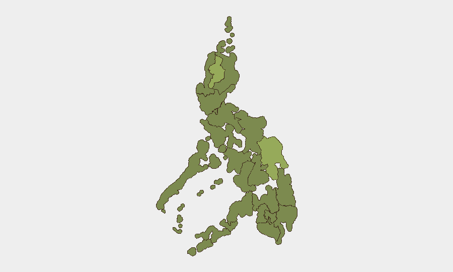
The Philippines faces a composite threat environment ranked #41 globally, with 39 tracked events reflecting tension across maritime disputes, internal security operations, and political friction. Recent event signals (July 10–12) indicate escalating rhetoric and small-arms confrontations tied to governance, religious actors, and international legal proceedings, though the overall national risk score remains moderate. Cordillera Administrative Region and Eastern Visayas drive sub-national risk significantly above the national average, while Metro Manila's elevated score reflects concentration of political and institutional volatility. The threat trajectory is tense but not acute; sustained monitoring of northern and eastern regions is warranted.
Key Developments
- 2026-07-12 · Armed Engagement · Philippines (nationwide) – Two separate small-arms combat incidents reported; second incident involved presidential security or official armed response. Context uncertain; investigation ongoing.
- 2026-07-12 · Government Threat Statement – Official government entity issued threat or warning; subject and target require clarification via follow-up intelligence.
- 2026-07-12 · Diplomatic Downgrade · Manila–Shanghai – Philippine government announced reduction in relations with Shanghai (likely Chinese municipal/provincial entity), signaling escalation in bilateral friction over South China Sea or economic ties.
- 2026-07-10 · International Legal Challenge – Philippine government issued public statement regarding The Hague (UN International Court), likely related to maritime law, territorial claims, or compliance proceedings.
- 2026-07-10 · Beijing Rejection – China publicly rejected Philippine position or proposal; consistent with ongoing South China Sea and West Philippine Sea disputes.
- 2026-07-10 · Police Investigation Launch – Philippine National Police initiated investigation; scope not yet specified in available signals.
Note: Live web research for the last 24–48 hours yielded limited recent Philippines-specific reporting. Typhoon Inday preparedness coverage and a July 9 South Cotabato youth firearms seizure were identified but fall outside the 48-hour window. Recommend direct social-media and wire-service monitoring for real-time confirmation of July 12 events.
Highest-Risk Areas
Cordillera Administrative Region (56.4) and Eastern Visayas (44.1) carry composite risk scores substantially above the national mean, driven by sustained patterns of armed group activity, resource competition, and limited state capacity in remote areas. Metro Manila (31.2), while significantly lower, remains elevated due to political volatility, large protest potential, and concentration of critical infrastructure and personnel. Mid-tier risk in Mimaropa, Cagayan Valley, and Western Visayas reflects ongoing maritime resource friction, informal armed groups, and porous borders. Corporate and NGO operations in Cordillera and Eastern Visayas should maintain heightened situational awareness; Manila operations should monitor official announcements and protest calendars closely.
How GeoBit Would Assist
Security teams should deploy AOI Monitoring & Early Warning on Cordillera and Eastern Visayas with real-time alerting for armed incidents and displacement; Intel Sweep and X/Telegram OSINT to track rhetorical escalation tied to The Hague proceedings and Manila–Shanghai tensions; and Network & Actor Analysis to map non-state armed groups and official security responses. Multi-language search and sentiment analysis will clarify intent behind the July 12 government threat statement and small-arms incidents. Conflict mapping and force-structure tracking supports risk assessment for specific facilities or travel routes in high-risk regions.
7-Day Outlook
Diplomatic and rhetorical tension will likely persist through mid-July as legal and bilateral disputes remain unresolved. Armed incidents in Cordillera and Eastern Visayas may continue at current low-level frequency; no imminent nationwide escalation is forecast. Personnel and asset security posture in Cordillera, Eastern Visayas, and Manila should remain elevated; routine movement and supply-chain planning should incorporate alternate routing and longer contingency windows.
Highest-Risk Areas — Ranked
| # | State / Region | Risk |
|---|---|---|
| 1 | Cordillera Administrative Region | 56.4 |
| 2 | Eastern Visayas | 44.1 |
| 3 | Metro Manila | 31.2 |
| 4 | Mimaropa | 29.8 |
| 5 | Cagayan Valley | 29.1 |
| 6 | Western Visayas | 27.1 |
| 7 | Bangsamoro | 26.4 |
| 8 | Caraga | 26.4 |
| 9 | Northern Mindanao | 26.4 |
| 10 | Soccsksargen | 26.4 |
| 11 | Davao Region | 26.4 |
| 12 | Ilocos Region | 26.4 |
Sources
Previous Daily Briefs
A new Philippines brief is written every day — each with its own risk map and downloadable CSV. Here's the last week; use the calendar to go further back.
📅 Browse every day by calendar →
Highlighted days have a brief. Tap a day for that day's map & analysis, or “csv” for that day's dataset ($5).
Atlas — our AI intelligence desk — emails them this snapshot personally. Nothing else, no list.