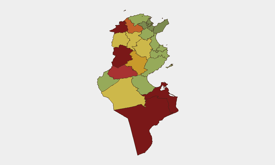
Situation Summary
Tunisia faces a compound crisis spanning environmental emergencies, infrastructure strain, civil unrest, and border security challenges. A sustained heatwave has triggered widespread wildfire activity (notably in Kef), strained the national power grid through rolling blackouts, and fueled public anger against the government. Concurrent pollution crises, cross-border closures, and cyber-enabled misinformation are degrading operational security and duty-of-care conditions across multiple regions.
Key Developments
- Nationwide fire and emergency response surge (as of 06:00 Friday, August 1–3): Civil Protection reported 547 interventions in 24 hours, including 78 firefighting operations and 173 road rescues, reflecting ongoing wildfire and heat-related pressure across multiple governorates.
- Kef wildfire containment ongoing (late July–early August, continuing): Authorities managing aftermath of near-600 fires during peak period around Sakiet Sidi Youssef and el-Gol; smoke and infrastructure vulnerabilities persist, with cleanup extending into the current week.
- Tunis civil unrest and power-cut anger (through early August, continuing): Sporadic protests and counter-demonstrations in central Tunis over prolonged blackouts (up to 12 hours) and economic hardship; tensions remain elevated mid-week.
- Gabes public health and pollution crisis (late July–early August, unresolved): Over 200 hospitalizations linked to phosphate plant emissions; ongoing demonstrations and closure demands reported in recent days.
- Ras Jdir border closure (maintained into early August): Tunisia–Libya crossing remains closed following a recent security incident, disrupting trade and cross-border movement.
- Cyber-crime misinformation operation and follow-on investigations (July 29 onwards, continuing): National Guard arrested six individuals (including four women) for spreading false social-media posts about a supposed prison fire; six additional suspects under investigation; authorities report ongoing account monitoring and links to terrorism and drug networks.
- National power grid strain (ongoing heatwave period): STEG implementing staggered cuts to manage cooling demand; widespread crop damage, industrial disruption, and compounded travel/infrastructure risk reported across recent days.
Highest-Risk Areas
Kasserine, Jendouba, Tataouine, and Médenine (ranks 92, 88, 85, 83 respectively) are the critical focus areas, driven by a combination of remote terrain, proximity to Libya, historical militant activity, and limited state capacity. Kasserine's volatility is particularly acute. Secondary tiers (Gafsa, Béja, Sidi Bouzid) face compounded risk from the heatwave-induced wildfire surge and power-grid instability, which degrade emergency response and civil stability. Northern and coastal governorates (Kef, Jendouba, Bizerte) are experiencing active wildfire and civil-order strain; southern regions (Gafsa, Tataouine, Médenine, Gabes) face simultaneous environmental, health, and cross-border security pressures.
How GeoBit Would Assist
Security teams should deploy AOI Monitoring & Early Warning on highest-risk governorates (especially Kasserine, Jendouba, Kef, and Gabes) to detect emerging incidents—wildfire spread, protest escalation, power-outage impacts—in real time. Intel Sweep and OSINT fusion (X/Twitter, Telegram, local news sources) can track misinformation campaigns and protest sentiment before mobilization. Routing & Network Analysis supports contingency planning for personnel movement around closed borders (Ras Jdir) and power-affected zones; environmental & health data integration informs duty-of-care protocols for heatwave and pollution exposure.
7-Day Outlook
Heatwave persistence will sustain fire and emergency-response pressure through mid-August; power cuts are likely to continue, further eroding public confidence and raising civil-unrest risk in urban centers. Border closures and cross-border security incidents may extend; pollution and health crises in Gabes are unlikely to resolve without structural intervention. Overall trajectory remains toward sustained compound stress on infrastructure, civil order, and cross-border mobility.
Highest-Risk Areas — Ranked
| # | State / Region | Risk |
|---|---|---|
| 1 | Kasserine | 92 |
| 2 | Jendouba | 88 |
| 3 | Tataouine | 85 |
| 4 | Médenine | 83 |
| 5 | Gafsa | 78 |
| 6 | Béja | 75 |
| 7 | Sidi Bouzid | 72 |
| 8 | Al Kaf | 70 |
| 9 | Kébili | 68 |
| 10 | Kairouan | 65 |
| 11 | Siliana | 62 |
| 12 | Tozeur | 58 |
Sources
Previous Daily Briefs
A new Tunisia brief is written every day — each with its own risk map and downloadable CSV. Here's the last week; use the calendar to go further back.
📅 Browse every day by calendar →
Highlighted days have a brief. Tap a day for that day's map & analysis, or “csv” for that day's dataset ($5).
Atlas — our AI intelligence desk — emails them this snapshot personally. Nothing else, no list.