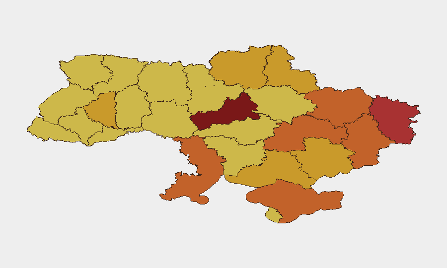
Situation Summary
Ukraine remains at elevated operational threat (rank #5 globally, composite score 100) driven by sustained large-scale Russian conventional strikes, contested urban combat in eastern oblasts, and reciprocal long-range infrastructure attacks. The July 2 mass missile and drone strike on Kyiv (570 munitions, 27–30 civilian casualties) and ongoing cross-border shelling in northern border zones have extended disruption into early July 4. The conflict trajectory reflects no significant de-escalation; instead, intensified kinetic operations and infrastructure targeting across multiple regions are expected to persist through the near term.
Key Developments
- Kyiv, July 2–4: Russian large-scale drone and missile strike (570 munitions) destroyed major Red Cross warehouse, killed at least 27–30 civilians, and triggered sustained air-raid alerts and power/utility disruption continuing into July 4; travel and emergency services remain impacted.[1][3]
- Sumy city, July 3: Russian guided bomb attack on civilian residential area caused multiple casualties including children; heightened local security measures and movement restrictions implemented in affected neighborhoods.[1][2]
- Northern Sumy and Kharkiv oblasts, July 3–4: Russian Northern Grouping maintained cross-border artillery and air strikes targeting buffer zones near Ukraine–Russia border; no confirmed territorial advances but elevated risk of sudden shelling and checkpoint delays for road movement.[1][2]
- Kostyantynivka, Donetsk oblast, July 3–4: Despite Putin's July 3 claim of full capture, battlefield reporting shows Russian forces control approximately 36% of the city via unconsolidated infiltration with active urban combat ongoing; extreme risk to civilian movement in this sector.[1]
- Kyiv and central oblasts (Cherkasy, Chernihiv), July 2–4: Sustained missile and drone campaign against civilian and energy infrastructure generated regular air-raid sirens, utility outages, and intermittent rail/road/aviation disruption.[1][2]
- Nationwide, July 4: Ukrainian long-range strikes on Russian oil and energy infrastructure continued as part of authorized 40-day deep-strike campaign initiated late June; prompts reciprocal Russian long-range attacks on Ukrainian cities, sustaining country-wide elevated threat posture.[1][5]
- Frontline sectors (eastern and southern oblasts), June 30–July 4: Confirmed artillery and tank operations continuing through July 4; affects travel corridors near active combat zones.[2][1]
Highest-Risk Areas
Kyiv (risk score 100) remains the single highest-risk location due to sustained missile and drone targeting of civilian infrastructure and military assets; the July 2 strike reinforces the capital's designation as priority Russian target. Cherkasy Oblast (91) follows as secondary critical risk, reflecting proximity to strike corridors and infrastructure targeting. Eastern oblasts—Donetsk (75.3), Luhansk (79.2), Kharkiv (73.7), and Sumy (71.8)—carry extreme risk from active ground combat, cross-border shelling, and contested urban operations; the Kostyantynivka fighting exemplifies the intensity of current kinetic activity in these zones. Northern border oblasts (Sumy, Kharkiv) face persistent cross-border artillery and infiltration threats with limited infrastructure redundancy.
How GeoBit Would Assist
Security teams should employ AOI Monitoring & Early Warning with persistent watch on Kyiv and Cherkasy Oblast to detect air-raid patterns and infrastructure targeting escalation. Battle Mapping and Conflict & Military force-structure tracking provide real-time clarity on contested urban sectors (e.g., Kostyantynivka) and frontline movement affecting overland routes. Routing & Network Analysis capabilities enable identification of alternative travel corridors avoiding missile-targeted infrastructure and active combat zones, while GIS & Spatial Analysis combined with Satellite & Imagery support facility and personnel risk assessment in high-threat sub-regions.
7-Day Outlook
Russian long-range strikes on Kyiv and central infrastructure are likely to continue at current or elevated intensity through July 10, sustaining air-raid alerts and utility disruption. Ground combat intensity in Donetsk (especially Kostyantynivka sector) and cross-border operations in Sumy–Kharkiv border zones are expected to remain high with no near-term territorial stabilization. Non-essential travel in all eastern oblasts and central regions should remain suspended; essential movement should route through southern or western corridors with real-time threat intelligence support.
Highest-Risk Areas — Ranked
| # | State / Region | Risk |
|---|---|---|
| 1 | Kyiv | 100 |
| 2 | Cherkasy Oblast | 91 |
| 3 | Luhansk Oblast | 79.2 |
| 4 | Autonomous Republic of Crimea | 75.7 |
| 5 | Donetsk Oblast | 75.3 |
| 6 | Dnipropetrovsk Oblast | 73.8 |
| 7 | Odesa Oblast | 73.8 |
| 8 | Kharkiv Oblast | 73.7 |
| 9 | Kherson Oblast | 72.7 |
| 10 | Sumy Oblast | 71.8 |
| 11 | Ternopil Oblast | 71.6 |
| 12 | Zaporizhia Oblast | 71.4 |
Sources
Previous Daily Briefs
A new Ukraine brief is written every day — each with its own risk map and downloadable CSV. Here's the last week; use the calendar to go further back.
📅 Browse every day by calendar →
Highlighted days have a brief. Tap a day for that day's map & analysis, or “csv” for that day's dataset ($5).
Atlas — our AI intelligence desk — emails them this snapshot personally. Nothing else, no list.