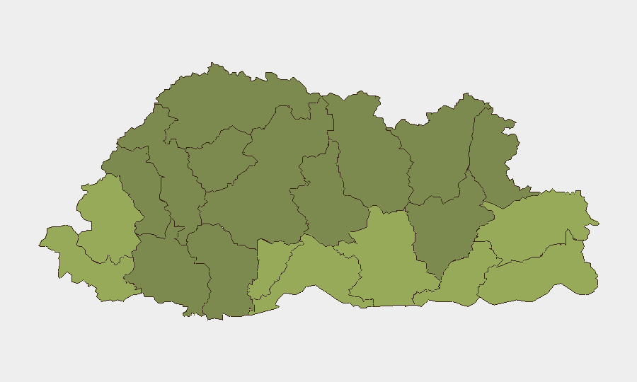
Situation Summary
Bhutan remains one of the world's lowest-threat operating environments with no verified security incidents, civil unrest, or infrastructure disruptions reported in the past 24–48 hours. The country's composite threat score of 3 reflects a stable political climate, routine law enforcement activity, and no active conflict drivers. Personnel and assets in Bhutan face minimal acute risk, though geographic factors keep certain border districts under baseline monitoring.
Key Developments
- Nationwide, 24–48h window (as of 31 July 2026): No discrete security, crime, civil unrest, or infrastructure incidents confirmed by GeoBit's event feeds, Bhutan Broadcasting Service, or major regional outlets. The operating environment remains operationally normal.
- Border region, India–Bhutan frontier (Chirang district, Assam), late July: A violent protest occurred at the Runikhata Forest Range Office and police station on the Indian side of the border, involving vehicle fires and police action. No spillover incidents or unrest have been reported inside Bhutanese territory; the event remains confined to Indian jurisdiction.
- Telecom/Infrastructure, nationwide (status update): A network connectivity disruption affected parts of Bhutan on 18–19 July. This incident is outside the current 24–48-hour assessment window and should not be treated as an active development. No new infrastructure failures have been reported.
- Crime posture, nationwide (mid-year aggregate): BBS reporting indicates a slight national crime increase in the first half of 2026, with shifts in domestic violence and sexual offense categories. This is aggregated, non-urgent data; no specific incidents have been flagged in the past 24–48 hours.
- Political stability, nationwide: Routine municipal and national-level politics dominate media coverage. Recent reporting centers on development priorities (water, disaster management) rather than unrest or political volatility.
Highest-Risk Areas
Samtse, Sarpang, Haa, and Pemagatshel Districts carry the highest composite risk scores (50–58), driven primarily by their proximity to the India–Bhutan border and historical geographic exposure rather than current acute incidents. No specific current-window security events are assigned to these areas; their elevation reflects baseline border-region considerations, including historical cross-border dynamics and supply-chain dependencies. Central and northern districts (Lhuntse, Gasa, Wangdue Phodrang) show lower risk, reflecting stable governance and distance from major friction points. Security teams should maintain standard monitoring protocols in border districts without assuming imminent threat activation.
How GeoBit Would Assist
Security teams in Bhutan would benefit from GeoBit's AOI Monitoring & Early Warning capability to sustain persistent watch over the southern border districts (Samtse, Sarpang, Haa) with automatic alerting if cross-border incidents emerge or domestic unrest surfaces. Intel Sweep and multi-language OSINT fusion (BBS, regional media, social-media sentiment analysis) provide continuous, low-cost situational awareness and event corroboration—critical for detecting early warning signs in an otherwise stable environment. Routing & Network Analysis supports alternative journey planning and asset positioning should localized border disruptions occur, ensuring duty-of-care compliance for personnel movement.
7-Day Outlook
No acute risk drivers are visible on the near-term horizon. Bhutan's low threat score and absence of current incidents suggest the 7-day outlook remains stable, with routine security posture appropriate. Continued baseline monitoring of border districts and regional media is prudent; escalation would require new triggering events, which current reporting does not forecast.
Highest-Risk Areas — Ranked
| # | State / Region | Risk |
|---|---|---|
| 1 | Samtse District | 58 |
| 2 | Sarpang District | 55 |
| 3 | Haa District | 52 |
| 4 | Pemagatshel District | 50 |
| 5 | Samdrup Jongkhar District | 48 |
| 6 | Tsirang District | 45 |
| 7 | Zhemgang District | 42 |
| 8 | Trashigang District | 40 |
| 9 | Mongar District | 38 |
| 10 | Gasa District | 35 |
| 11 | Lhuntse District | 32 |
| 12 | Wangdue Phodrang District | 30 |
Sources
Previous Daily Briefs
A new Bhutan brief is written every day — each with its own risk map and downloadable CSV. Here's the last week; use the calendar to go further back.
📅 Browse every day by calendar →
Highlighted days have a brief. Tap a day for that day's map & analysis, or “csv” for that day's dataset ($5).
Atlas — our AI intelligence desk — emails them this snapshot personally. Nothing else, no list.