Situation Summary
Burkina Faso remains at elevated security risk (composite threat score 89, ranked #25 globally) driven by a volatile combination of diplomatic rupture, tightening internal repression, and sustained militant activity in northern regions. The junta's abrupt severance of relations with France on 27–28 June, coupled with heightened restrictions on foreign nationals and domestic civil actors, signals accelerating political instability and potential for secondary effects on expatriate safety and operational continuity. While no major terror attacks or mass-casualty incidents have been confirmed in the last 24–48 hours, the security environment remains fragile, with Centre region posing the highest sub-national risk (92.2) and northern/Sahel zones sustaining ongoing armed-group pressure.
Key Developments
- Ouagadougou, 27–28 June – The military government formally severed diplomatic relations with France, expelled key French diplomats within 48 hours, and ordered termination of French military presence in the capital, citing neo-colonial interference and alleged support for terrorist networks.
- Ouagadougou, 27–28 June – French embassy operations were shut down or heavily restricted; French armed forces were given a short deadline to depart, signaling a major shift in external security partnerships and reducing Western military presence on the ground.
- Burkina Faso (nationwide), 27–28 June – Authorities intensified coercive domestic measures, including property seizures, detentions, and rejection of organized student and civic demands, indicating heightened risk of civil unrest and potential for protests in urban centers.
- Burkina Faso (nationwide), 28 June – A vague "demand" directive was issued affecting tourists and foreign nationals, flagged as a potential tightening of controls on foreigners and travel; enforcement mechanisms and precise scope remain unclear.
- Ouagadougou, 27–28 June – In parallel with the France rupture, the presidency publicized renewed diplomatic engagement with Israel's ambassador, signaling strategic realignment toward alternative security and technical partnerships.
- North and Sahel regions, through 27–28 June – Burkinabè military operations continued against militant strongholds with increased rural deployments; no specific large-scale terror attack or mass-casualty incident confirmed in the past 48 hours.
Highest-Risk Areas
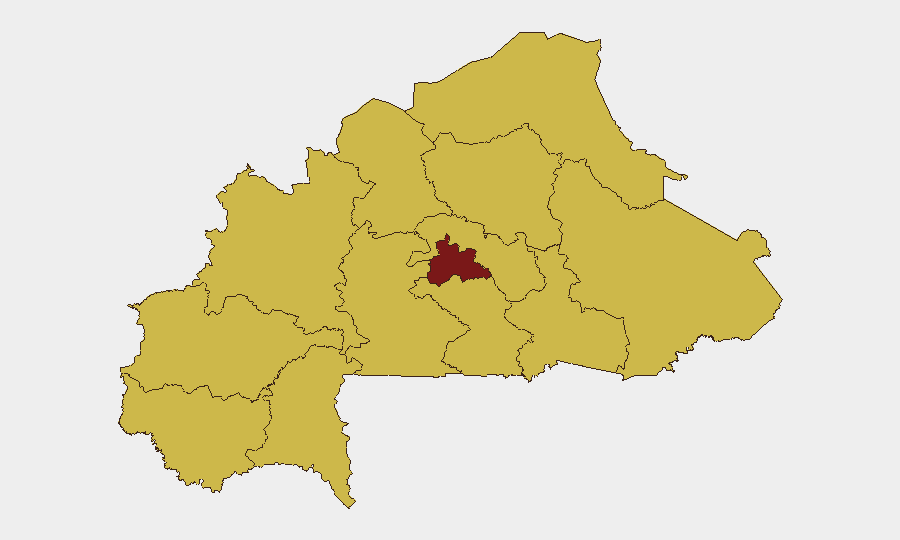
Centre region (92.2) dominates the threat landscape, reflecting proximity to Ouagadougou's political volatility and ongoing militant activity. The remaining ten regions cluster at 62.2, with Upper-Basins, Boucle du Mouhoun, Sahel, and North ranking highest within this band due to persistent armed-group presence and weak state capacity. The diplomatic rupture with France and tightening of internal controls increase risk across urban centres (particularly the capital) for expatriate movement restrictions and potential secondary security incidents, while northern and Sahel zones face continuous militant infiltration and armed clashes unrelated to the recent diplomatic shifts.
How GeoBit Would Assist
Security and risk teams should deploy AOI Monitoring & Early Warning on Ouagadougou and other major urban centres to track protest activity, checkpoint density, and movement restrictions in real time. Intelligence & OSINT (X/Twitter, Telegram, and multi-language feeds) would provide rapid signals on junta policy enforcement, diplomatic messaging, and foreign-national detention patterns. Network & Actor Analysis combined with Conflict & Military tracking would enable continuous assessment of French military withdrawal timelines, local militia realignment, and militant group repositioning in northern regions.
7-Day Outlook
The diplomatic severance with France is likely to proceed as announced, reducing Western military intelligence-sharing and creating a security coordination vacuum that militant groups may exploit. Domestic repression is expected to persist and potentially escalate if civil unrest emerges in response to the regime's intensifying controls. Risk for expatriates and foreign-owned assets will remain elevated in Ouagadougou and major cities over the next week; North and Sahel regions will continue experiencing armed-group pressure with limited external peacekeeping presence.
Highest-Risk Areas — Ranked
| # | State / Region | Risk |
|---|---|---|
| 1 | Centre | 92.2 |
| 2 | Upper-Basins | 62.2 |
| 3 | Boucle du Mouhoun | 62.2 |
| 4 | Central-West | 62.2 |
| 5 | Central-South | 62.2 |
| 6 | Central-East | 62.2 |
| 7 | Waterfalls | 62.2 |
| 8 | Southwest | 62.2 |
| 9 | Sahel | 62.2 |
| 10 | Central-North | 62.2 |
| 11 | East | 62.2 |
| 12 | North | 62.2 |
Sources
Previous Daily Briefs
A new Burkina Faso brief is written every day — each with its own risk map and downloadable CSV. Here's the last week; use the calendar to go further back.
📅 Browse every day by calendar →
Highlighted days have a brief. Tap a day for that day's map & analysis, or “csv” for that day's dataset ($5).