Situation Summary
Comoros remains a low-frequency threat environment globally (composite score 6/100), with no confirmed security incidents recorded in the current reporting window. However, sub-national risk concentration is pronounced: Anjouan Island presents significantly elevated risk (88/100), driven by historical governance fragmentation and civil unrest potential, while Grande Comore maintains moderate-to-elevated baseline risk (72/100). The overall threat trajectory remains stable but localized, with institutional weakness and inter-island political tension as persistent underlying drivers rather than acute crisis indicators.
Key Developments
No discrete security incidents were confirmed in Comoros during the last 24–48 hours. Available open-source reporting does not contain verified, dated incident corroboration for this period. Background context from 27 July 2026 noted government infighting, but this falls outside the current reporting window and should not be treated as an active development. Security teams should note that absence of incident reporting does not indicate absence of risk; rather, it reflects the low operational visibility typical of smaller island states with limited international media coverage.
Highest-Risk Areas
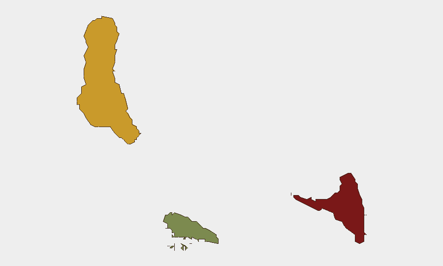
Anjouan Island dominates the risk profile (score 88/100), reflecting a history of separatist movements, weak state capacity, and periodic civil unrest since the 1990s. This island presents the highest probability of localized instability, including inter-communal tension and potential governance dysfunction. Grande Comore (score 72/100) follows as the primary population and administrative center; while more stable institutionally than Anjouan, it remains vulnerable to spillover effects from inter-island disputes and underlying economic fragility. Moheli (score 35/100) presents materially lower risk and remains a secondary concern for most corporate and personnel operations.
How GeoBit Would Assist
Security teams operating in or traveling to Comoros should employ persistent AOI monitoring on Anjouan and Grande Comore to detect early indicators of civil unrest, political escalation, or maritime security incidents. OSINT fusion across X/Twitter, local news, and Telegram channels—combined with multi-language search and sentiment analysis—would establish a continuous watch for protest activity, government announcements, or port/aviation disruptions. Routing & network analysis can be applied to pre-plan alternative transport and supply-chain pathways should primary inter-island or port operations become disrupted. Regime-stability search and political risk monitoring would support duty-of-care assessment during background political friction periods.
7-Day Outlook
No acute security escalation is forecast for the immediate week. Baseline institutional instability in Anjouan remains chronic; the likelihood of sudden violent incident is low but non-zero, particularly around governance transitions or inter-island resource disputes. Security teams should maintain passive monitoring posture and update contingency protocols quarterly or upon receipt of GeoBit alerts signaling political or civil unrest indicators.
Report Date: 2 August 2026
Data Recency: Last 24–48 hours (incidents); live web research conducted.
Next Update: 3 August 2026
Highest-Risk Areas — Ranked
| # | State / Region | Risk |
|---|---|---|
| 1 | Anjouan | 88 |
| 2 | Grande Comore | 72 |
| 3 | Moheli | 35 |
Sources
Previous Daily Briefs
A new Comoros brief is written every day — each with its own risk map and downloadable CSV. Here's the last week; use the calendar to go further back.
📅 Browse every day by calendar →
Highlighted days have a brief. Tap a day for that day's map & analysis, or “csv” for that day's dataset ($5).
Atlas — our AI intelligence desk — emails them this snapshot personally. Nothing else, no list.