Situation Summary
East Timor remains a low-threat environment globally (composite threat score 3/10), with no reported security incidents, civil unrest, or crime spikes in the past 24–48 hours. The country's risk profile is concentrated in urban and western border zones, particularly Dili, reflecting routine organized-crime and gang activity rather than political instability or active conflict. Recent activity has been limited to routine diplomatic engagement (Chinese defence minister visit on 19 August) and economic data releases, neither indicating acute deterioration in the security environment.
Key Developments
- Dili – 19 August 2026: Chinese Defence Minister Dong Jun concluded a high-level visit, publicly praising Timor-Leste for "strategic autonomy and fairness." No protests, violence, or security-force deployments were reported in connection with the visit. This represents routine diplomatic engagement rather than a security incident.
- Dili – 19 August 2026: Timor-Leste's National Institute of Statistics released July inflation data (0.2% consumer price increase). No associated reporting of public unrest, shortages, or economic protests has emerged.
- No discrete security, crime, or unrest incidents reported across East Timor in the 24–48 hour window. Mainstream news feeds and international conflict/crime aggregators have not surfaced any new attacks, gang violence, inter-community clashes, or law-enforcement operations of note.
Highest-Risk Areas
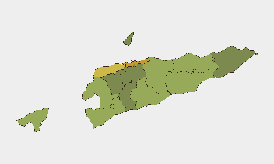
Dili (risk 72) and Liquiçá (risk 62) drive the national risk profile, followed by Baucau (58) and Cova Lima (55). These areas reflect concentrations of organized crime, gang activity, and inter-community tensions typical of urban centers and western border regions. Dili's risk score reflects its status as the capital and largest urban center; gang violence and robbery remain endemic but localized. Western districts (Liquiçá, Cova Lima, Bobonaro) historically see friction tied to land disputes, informal markets, and cross-border movement. Lower-risk eastern and central regions (Aileu, Ermera, Ainaro) remain relatively stable, suggesting risk is primarily a function of urban density and proximity to porous borders rather than political instability.
How GeoBit Would Assist
Organizations with personnel or assets in East Timor should employ AOI Monitoring & Early Warning to track Dili, Liquiçá, and Baucau for emerging unrest, crime spikes, or gang activity with configured alerting thresholds. Intel Sweep and multi-language OSINT (including social media and Telegram channel monitoring) would capture localized crime reporting, street-level security incidents, and community tensions not always covered by mainstream media. Routing & Network Analysis enables security teams to model alternative transport routes in Dili and western districts to avoid known gang or high-crime zones during travel or supply-chain operations.
7-Day Outlook
No acute escalation is anticipated over the next seven days. The diplomatic visit and economic data release do not signal policy shifts affecting business or expatriate safety. Standard vigilance around petty crime, robbery, and gang activity in urban areas remains appropriate; organized crime in Dili and western border zones is typically opportunistic and non-political, making it predictable and containable through standard duty-of-care protocols.
Highest-Risk Areas — Ranked
| # | State / Region | Risk |
|---|---|---|
| 1 | Dili | 72 |
| 2 | Liquiçá | 62 |
| 3 | Baucau | 58 |
| 4 | Cova Lima | 55 |
| 5 | Bobonaro | 53 |
| 6 | Oecussi-Ambeno | 48 |
| 7 | Manufahi | 45 |
| 8 | Viqueque | 42 |
| 9 | Manatuto | 40 |
| 10 | Ainaro | 38 |
| 11 | Ermera | 36 |
| 12 | Aileu | 32 |
Sources
Previous Daily Briefs
A new East Timor brief is written every day — each with its own risk map and downloadable CSV. Here's the last week; use the calendar to go further back.
- August 18, 2026
- August 16, 2026
- August 14, 2026
- August 12, 2026
- August 10, 2026
- August 8, 2026
- August 6, 2026
📅 Browse every day by calendar →
Highlighted days have a brief. Tap a day for that day's map & analysis, or “csv” for that day's dataset ($5).
Atlas — our AI intelligence desk — emails them this snapshot personally. Nothing else, no list.