Situation Summary
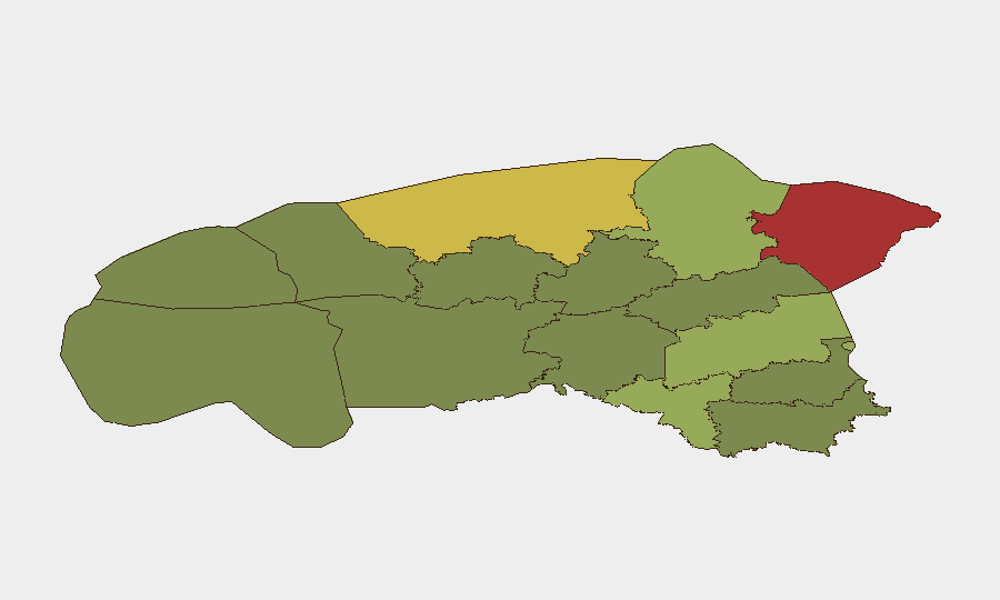
Estonia remains in a low-threat security environment with no major incidents reported in the last 24–48 hours. Sub-national risk concentrations in northeastern and central counties (Ida-Viru, Harju, Tartu) reflect persistent hybrid-threat exposure and infrastructure criticality rather than active violence. Current operational focus is on routine hazards—localized flooding, traffic safety, and precautionary bomb-threat investigations—with no indication of escalating civil unrest, organized crime activity, or cross-border security incidents.
Key Developments
- Tõrva, Valga County – localized flooding and evacuations (4–5 August 2026)
Emergency services evacuated 10 residents following heavy rainfall and localized inundation. No wider infrastructure disruption or secondary incidents reported; situation being managed by regional authorities.
- Estonia-wide – traffic accidents (4 August 2026)
Four separate traffic crashes across the country injured seven people. Incidents are classified as routine road-safety events under police investigation; no indication of systemic transport network failure or security nexus.
- National – ongoing bomb-threat call investigations
Police have received multiple precautionary bomb-threat reports in recent days and are conducting standard response checks. No confirmed detonations, explosive devices deployed, or injuries attributed to these calls in the current reporting window.
- South Estonia – drone discovery remains under analysis (incident from weeks prior; no new incursion in last 48 hours)
An attack drone carrying approximately 5 kg of explosives, believed linked to June cross-border activity, continues to be analyzed by authorities. No new drone detection or airspace breach has been reported since discovery; ongoing media commentary reflects strategic threat discourse rather than acute incident.
- National – interior ministry reiterates crisis-preparedness assessments
Estonian leadership has publicly noted gaps between current crisis-response capacity and evolving threat scenarios. This represents strategic planning discourse rather than a discrete security event or policy change in the last 48 hours.
Highest-Risk Areas
Ida-Viru County (risk 78) and Harju County (risk 68) drive the national composite risk profile due to critical infrastructure density, proximity to Russia, and historical targeting by hybrid actors. Tartu County (risk 58) carries elevated risk tied to academic and technology-sector concentration. The northeastern corridor (Ida-Viru, Lääne-Viru) faces persistent exposure to cross-border intelligence activity and supply-chain disruption; Harju's risk reflects Tallinn's status as a capital, financial hub, and NATO/EU node. Southern and western counties (Pärnu, Võru, Põlva) register significantly lower composite scores, indicating lower threat concentration.
How GeoBit Would Assist
Corporate security teams in Estonia would deploy Intel Sweep and multi-language OSINT fusion to monitor hybrid-threat communications and sentiment shifts in high-risk counties (Ida-Viru, Harju) before they manifest as operational events. AOI Monitoring with persistent alerting on critical infrastructure sites, border zones, and transport corridors would provide early warning of emerging threats—floods, unrest, or transnational activity. GIS & Spatial Analysis combined with Routing & Network Analysis enables duty-of-care teams to identify safe alternative routes and business continuity corridors if incidents disrupt primary transport or utility networks.
7-Day Outlook
No major escalation is anticipated in the near term; baseline threat conditions are expected to persist. Regional flood-response operations and routine law-enforcement activity will likely continue. Authorities remain alert to recurring hybrid-threat vectors (disinformation, minor cross-border probes) characteristic of the current operating environment; corporate risk teams should maintain standard monitoring protocols and periodic review of crisis-response plans.
Highest-Risk Areas — Ranked
| # | State / Region | Risk |
|---|---|---|
| 1 | Ida-Viru County | 78 |
| 2 | Harju County | 68 |
| 3 | Tartu County | 58 |
| 4 | Valga County | 55 |
| 5 | Lääne-Viru County | 52 |
| 6 | Pärnu County | 35 |
| 7 | Rapla County | 32 |
| 8 | Jõgeva County | 30 |
| 9 | Järva County | 28 |
| 10 | Viljandi County | 25 |
| 11 | Põlva County | 22 |
| 12 | Võru County | 18 |
Sources
Previous Daily Briefs
A new Estonia brief is written every day — each with its own risk map and downloadable CSV. Here's the last week; use the calendar to go further back.
📅 Browse every day by calendar →
Highlighted days have a brief. Tap a day for that day's map & analysis, or “csv” for that day's dataset ($5).
Atlas — our AI intelligence desk — emails them this snapshot personally. Nothing else, no list.