Situation Summary
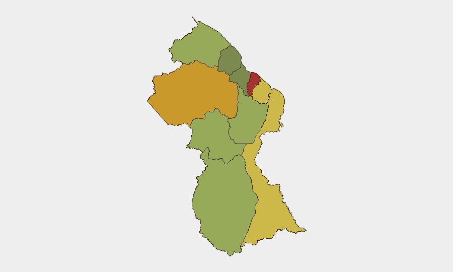
Guyana remains a low-threat environment globally (rank #108, composite score 14) with no tracked security events in the last 24–48 hours. However, sub-national risk concentration is significant: Demerara-Mahaica (Georgetown metropolitan area) presents the highest threat profile at risk score 78, driven by persistent armed robbery, gang violence, and firearm discharge near government installations. The broader pattern over the past week reflects opportunistic street crime and armed confrontations rather than organized instability or political tension.
Key Developments
No security incidents with confirmed occurrence dates within the last 24–48 hours (24–25 August 2026) could be corroborated from available open-source material. Recent reportage (18–23 August) documented armed robbery, shooting incidents, and a police response to an armed suspect in West Bank Demerara and Georgetown, but these fall outside the immediate reporting window. A potential standoff involving residents and a miner at Chinese Landing (Region 1) was referenced in 24 August broadcast coverage, but no specific escalation or incident date could be independently confirmed.
Recommendation: Duty-of-care teams should monitor regional news feeds for any overnight developments; the absence of reported incidents in the last 24 hours does not indicate reduced baseline risk.
Highest-Risk Areas
Demerara-Mahaica and Cuyuni-Mazaruni together account for nearly 40% of the country's tracked sub-national threat score. Demerara-Mahaica encompasses Georgetown and surrounding urban settlements, where concentrated population density, informal economy activity, and access to firearms create repeated armed-robbery and gang-violence hotspots. Cuyuni-Mazaruni, which includes gold-mining and interior regions, presents distinct risk drivers: resource-dispute confrontations, informal settlement conflicts, and limited law-enforcement presence. Mahaica-Berbice and East Berbice-Corentyne compound this pattern with moderate risk scores reflecting similar rural-crime and inter-community tension dynamics.
How GeoBit Would Assist
Security teams managing personnel or assets in Guyana should deploy AOI Monitoring & Early Warning on high-risk sub-regions (Demerara-Mahaica, Cuyuni-Mazaruni) to capture incident alerts and unrest signals in real time. Multi-language OSINT fusion—combining local news, social media sentiment analysis (X/Twitter, Telegram), and regional broadcast monitoring—provides faster, context-aware intelligence on emerging gang activity, resource conflicts, or police operations than manual daily review. Routing & Network Analysis should be used to pre-plan alternative movement corridors in and around Georgetown and mining zones, reducing exposure to known violence hotspots during high-risk hours.
7-Day Outlook
Armed street crime and robbery in Georgetown and West Bank Demerara will likely persist at baseline levels absent major law-enforcement operations or gang-leadership disruptions. Interior mining regions may see periodic confrontations between operators and informal settlers or environmental actors, particularly during peak extraction seasons. No indicators suggest imminent escalation to organized political instability or large-scale civil unrest.
Highest-Risk Areas — Ranked
| # | State / Region | Risk |
|---|---|---|
| 1 | Demerara-Mahaica | 78 |
| 2 | Cuyuni-Mazaruni | 72 |
| 3 | Mahaica-Berbice | 65 |
| 4 | East Berbice-Corentyne | 62 |
| 5 | Upper Demerara-Berbice | 58 |
| 6 | Potaro-Siparuni | 48 |
| 7 | Barima-Waini | 45 |
| 8 | Upper Takutu-Upper Essequibo | 42 |
| 9 | Pomeroon-Supenaam | 38 |
| 10 | Essequibo Islands | 35 |
Sources
Previous Daily Briefs
A new Guyana brief is written every day — each with its own risk map and downloadable CSV. Here's the last week; use the calendar to go further back.
- August 23, 2026
- August 21, 2026
- August 19, 2026
- August 17, 2026
- August 15, 2026
- August 13, 2026
- August 11, 2026
📅 Browse every day by calendar →
Highlighted days have a brief. Tap a day for that day's map & analysis, or “csv” for that day's dataset ($5).
Atlas — our AI intelligence desk — emails them this snapshot personally. Nothing else, no list.