Situation Summary
Ivory Coast remains a moderate-risk environment (global rank #68) with localized security pressures concentrated in the northern and northeastern districts. Recent developments include intercommunal violence, internal security breaches, and maritime trafficking interdiction, indicating persistent vulnerability to criminality and community tensions rather than systemic state collapse. The security picture remains stable at the national level, with risks heavily concentrated in peripheral regions distant from the capital.
Key Developments
- 2026-08-08 · Armed Robbery & Homicide, Daloa – A night security guard of Malian nationality murdered a colleague and stole over 47.5 million FCFA from company premises; suspect arrested by the Brigade de Répression de l'Illégalité (BRI). Indicates insider threat vulnerability in cash-handling operations and potential cross-border security staff vetting gaps.
- 2026-08-08 · Maritime Interdiction, Unspecified Port – Ivorian security authorities detained the Comoros-flagged cargo vessel *IB Atlantic IV* following a maritime pursuit linked to drug-trafficking activity. Suggests ongoing transnational narcotics transit through Ivory Coast's maritime domain.
- 2026-08-05 · Intercommunal Violence, Kossandji (Alépé Department) – Overnight violent clashes between autochthonous Akyé youth and allochthonous Mossi/Lobi communities resulted in at least 3 deaths, multiple injuries, and burned structures. Reflects persistent land-tenure and resource-access tensions in southern districts, with potential for escalation if mediation fails.
Highest-Risk Areas
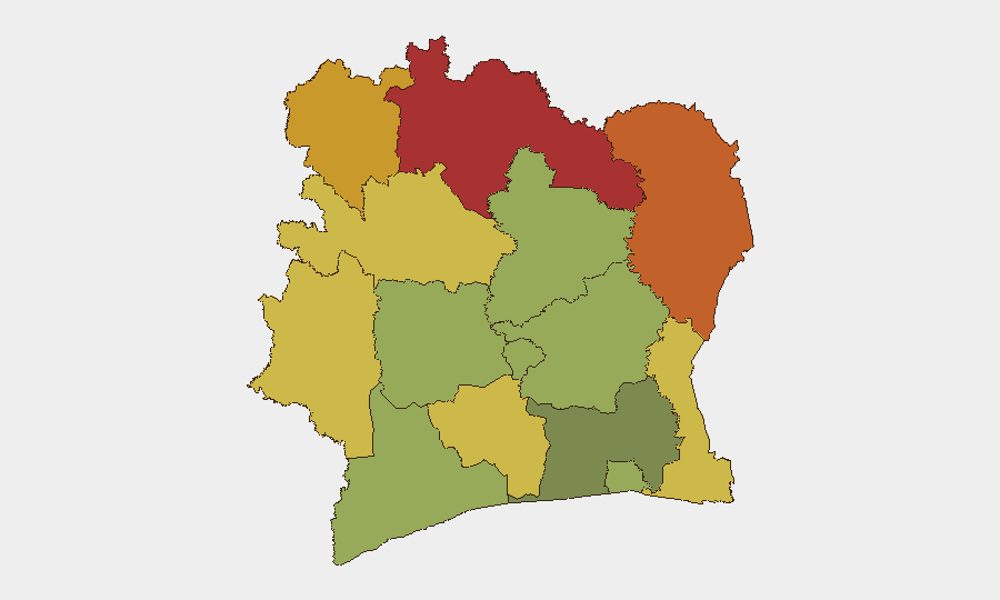
The northern tier—Savanes (78), Zanzan (75), Denguélé (72), and Comoé (70)—drives the country's composite threat score, reflecting remoteness from state security capacity, porous borders with Mali and Burkina Faso, and endemic cattle-rustling and trafficking networks. Montagnes and Woroba districts (68, 65) represent secondary hotspots rooted in resource competition and weak administrative presence. Abidjan (45) remains substantially lower-risk than peripheral zones, though insider crime (as evidenced by the Daloa incident) and maritime vulnerability persist. Northern and northeastern exposure appears driven by cross-border smuggling, intercommunal resource disputes, and limited government oversight rather than organized insurgency.
How GeoBit Would Assist
Intel Sweep and multi-language OSINT (French-language media, social platforms, and regional networks) provide real-time visibility into emerging intercommunal tensions and trafficking patterns across high-risk districts. Maritime & Aviation tracking and entity extraction enable rapid detection of illicit maritime activity and identification of trafficking networks transiting Ivorian waters. AOI Monitoring & Early Warning with persistent surveillance of Savanes, Zanzan, and border zones would alert security teams to mobilization signals, commodity smuggling spikes, or cross-border incursions before escalation, complementing duty-of-care protocols for remote field operations.
7-Day Outlook
Intercommunal tensions in southern districts may persist absent rapid local conflict resolution; no indicators of broader destabilization are evident. Maritime interdiction activity will likely continue as part of routine anti-trafficking enforcement. Northern district risk remains structurally elevated but stable, with no signals of imminent organized violence or state-level disruption.
Highest-Risk Areas — Ranked
| # | State / Region | Risk |
|---|---|---|
| 1 | Savanes District | 78 |
| 2 | Zanzan District | 75 |
| 3 | Denguélé District | 72 |
| 4 | Comoé District | 70 |
| 5 | Montagnes District | 68 |
| 6 | Woroba District | 65 |
| 7 | Gôh-Djiboua District | 60 |
| 8 | Sassandra-Marahoué District | 58 |
| 9 | Vallée du Bandama District | 55 |
| 10 | Bas-Sassandra District | 52 |
| 11 | Lacs District | 48 |
| 12 | Abidjan | 45 |
Sources
Previous Daily Briefs
A new Ivory Coast brief is written every day — each with its own risk map and downloadable CSV. Here's the last week; use the calendar to go further back.
- August 11, 2026
- August 10, 2026
- August 9, 2026
- August 8, 2026
- August 7, 2026
- August 6, 2026
- August 5, 2026
📅 Browse every day by calendar →
Highlighted days have a brief. Tap a day for that day's map & analysis, or “csv” for that day's dataset ($5).
Atlas — our AI intelligence desk — emails them this snapshot personally. Nothing else, no list.