Situation Summary
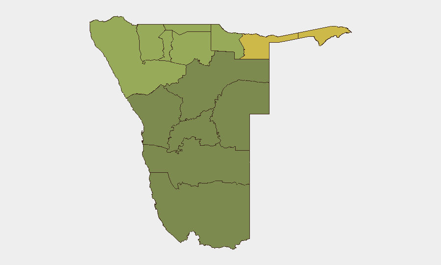
Namibia remains a low-threat environment globally (ranked #106, composite score 14) with no tracked conflict events, but underlying crime and interpersonal violence persist in localized pockets. Recent incidents reflect endemic domestic violence and armed-crime activity rather than organized instability or political tension. The security picture is regionally stratified: northern border regions (Zambezi, Kavango East/West, Kunene) carry elevated risk scores (52–68), while the central and southern interior remain comparatively secure. Open-source reporting for the last 24–48 hours shows no major incidents, civil unrest, infrastructure disruption, or terrorism activity.
Key Developments
No major security incidents with verified reports in Namibia have emerged in the last 24 hours (2026-08-16–17).
Background context (outside current 24–48h window, included for situational awareness):
- 2026-08-10, Otjozondjupa Region (Otavi area): A 16-year-old girl was raped and fatally shot at a farm ~62 km from Otavi; suspect armed with a stolen firearm remained at large.
- 2026-08-09, multiple locations: Three separate violent-crime incidents were recorded—a domestic assault (three victims, suspect arrested), a homicide at Etalaleko location (suspect arrested), and a fatal stabbing at Ubib Reserve (suspect arrested)—suggesting ongoing spikes in interpersonal and domestic violence.
These incidents underscore a pattern of localized violent crime and firearm access rather than coordinated instability.
Highest-Risk Areas
Zambezi Region (risk score 68) and the two Kavango regions (62, 58) present the most elevated risk profiles in Namibia, reflecting a combination of border-proximity dynamics, illicit-firearms circulation, cross-border movement, and limited state-security presence. Kunene (52) and Oshikoto (48) extend the high-risk corridor northward along the Angola border. These five regions collectively account for the bulk of tracked events and are characterized by cattle rustling, armed robbery, poaching, and spillover violence from Angola's ongoing security challenges. By contrast, Erongo, Hardap, and Omaheke (southern and eastern interior) score substantially lower (12–35), indicating less acute incident clustering and stronger institutional capacity. The disparity reflects geography: northern regions face cross-border instability and weak state presence; southern and central areas benefit from better infrastructure, proximity to economic centers (Windhoek, Walvis Bay), and higher policing density.
How GeoBit Would Assist
Security teams operating in Namibia would benefit from AOI Monitoring & Early Warning configured on high-risk zones (Zambezi, Kavango East, Kunene) to detect upticks in violent incidents, armed movement, or cross-border activity with real-time alerting. Multi-language OSINT & social-media feeds (X/Twitter, local Namibian media, WhatsApp networks) across northern locations would surface localized incidents faster than official channels. Routing & Network Analysis would enable alternative-route planning for personnel or convoys transiting high-risk regions, reducing exposure to known incident hotspots.
7-Day Outlook
No indicators of imminent escalation, mass unrest, or political instability are apparent. Violent crime is expected to remain episodic and localized rather than systemic; northern border regions will likely continue to experience lower-level armed activity and poaching-related incidents tied to Angola's security environment. Security posture should remain standard for the region, with heightened field protocols in Zambezi and Kavango areas.
Highest-Risk Areas — Ranked
| # | State / Region | Risk |
|---|---|---|
| 1 | Zambezi | 68 |
| 2 | Kavango East | 62 |
| 3 | Kavango West | 58 |
| 4 | Kunene Region | 52 |
| 5 | Oshikoto | 48 |
| 6 | Ohangwena | 45 |
| 7 | Omusati | 42 |
| 8 | Oshana | 40 |
| 9 | Otjozondjupa | 35 |
| 10 | Erongo Region | 32 |
| 11 | Hardap | 28 |
| 12 | Omaheke | 25 |
Sources
Previous Daily Briefs
A new Namibia brief is written every day — each with its own risk map and downloadable CSV. Here's the last week; use the calendar to go further back.
- August 15, 2026
- August 13, 2026
- August 11, 2026
- August 9, 2026
- August 7, 2026
- August 5, 2026
- August 4, 2026
📅 Browse every day by calendar →
Highlighted days have a brief. Tap a day for that day's map & analysis, or “csv” for that day's dataset ($5).
Atlas — our AI intelligence desk — emails them this snapshot personally. Nothing else, no list.