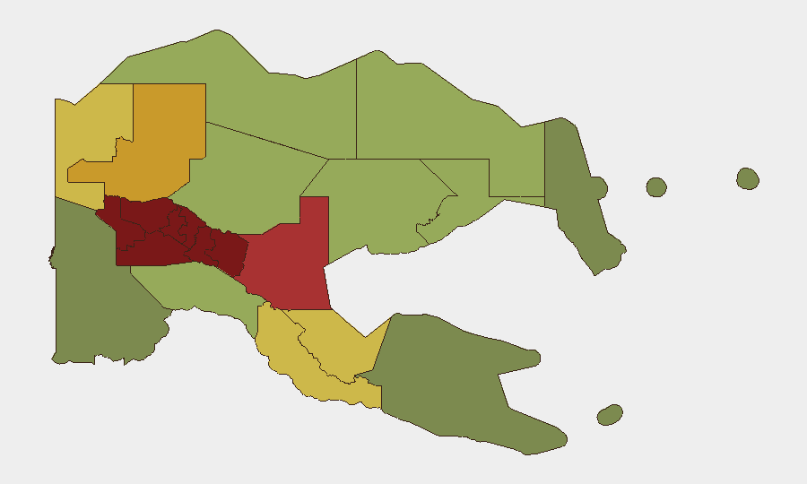
Situation Summary
Papua New Guinea remains at composite threat rank #82 globally, driven primarily by endemic crime and gang violence rather than political instability or terrorism. The last 48 hours have yielded sparse confirmed incident reporting, though regional patterns—particularly in the Highlands and National Capital District—show ongoing armed robbery, tribal conflict, and public violence. The security environment remains volatile but not acutely escalating; risk is concentrated in specific provinces and transport corridors.
Key Developments
- Enga Province (2026-08-17): Second councillor arrested in connection with tribal violence pattern; incident reflects institutionalized conflict linked to resource disputes and customary law breakdown in one of PNG's highest-risk regions.
- Madang Airport Road (2026-08-09): Two separate armed attacks on government vehicles reported same day—one involving gunfire against a bus, the second involving stoning—suggesting either organized targeting or heightened roadway insecurity in a key transport corridor.
- Baliem Valley, Eastern Highlands (2026-08-09): Shooting incident at Cultural Festival injured two civilians; trigger remains undetermined and warrants follow-up analysis to distinguish between accidental discharge, gang activity, or inter-communal violence.
- Wewak–Maprik Motor Route, East Sepik (2026-08-10): Armed robbery reported on regional transit corridor; consistent with documented pattern of transit-zone vulnerability in East Sepik Province (risk rank #10).
- Port Moresby, National Capital District (2026-08-08): Fourteen-person armed public clash reflects ongoing urban gang activity and armed conflict in the nation's capital, the second-highest-risk province by GeoBit composite score.
- Cross-Border Drug Interdiction (2026-08-19): Indonesian Navy intercepted marijuana smuggling attempt from Papua New Guinea toward Jayapura; not a PNG-internal incident but signals organized cross-border crime networks and potential porous border security on PNG's western edge.
Highest-Risk Areas
The Southern Highlands (risk 98), Enga (96), and Hela (94) provinces drive overall national threat score. These three Highlands regions are characterized by tribal conflict over land and resource rights, limited state authority, high prevalence of small-arms ownership, and weak law enforcement. The Eastern Highlands, Western Highlands, and Jiwaka round out the top six; collectively, the Highlands account for entrenched customary violence, inter-clan warfare, and gang activity. The National Capital District (rank #7) concentrates urban armed robbery, gang turf wars, and public order incidents. East Sepik and surrounding provinces show elevated transit insecurity along key motor routes.
How GeoBit Would Assist
AOI Monitoring & Early Warning with persistent watches on high-risk provinces—particularly the Highlands, Port Moresby, and Madang transit corridors—would provide corporate security teams real-time alerting on emerging incident clusters and pattern escalation. Routing & Network Analysis can identify safer alternative roads and travel windows by cross-referencing live incident data with geographic and temporal patterns. OSINT fusion and multi-language search (including monitoring of local PNG media, social platforms, and community reporting) fills gaps in English-language reporting and surfaces tribal/customary violence triggers weeks before mainstream news cycles.
7-Day Outlook
No acute escalation is forecast. Tribal violence in the Highlands will likely persist at baseline levels, with occasional spillover into provincial centers. Urban gang activity in Port Moresby may spike around week-end periods. Transit security on major roads (Madang Airport Road, Wewak–Maprik route) remains elevated; companies should maintain heightened duty-of-care protocols for staff and asset movement.
Highest-Risk Areas — Ranked
| # | State / Region | Risk |
|---|---|---|
| 1 | Southern Highlands | 98 |
| 2 | Enga | 96 |
| 3 | Hela | 94 |
| 4 | Eastern Highlands | 92 |
| 5 | Western Highlands | 90 |
| 6 | Jiwaka | 88 |
| 7 | National Capital District | 85 |
| 8 | Simbu | 82 |
| 9 | Morobe | 78 |
| 10 | East Sepik | 72 |
| 11 | Sandaun | 68 |
| 12 | Oro | 66 |
Sources
Previous Daily Briefs
A new Papua New Guinea brief is written every day — each with its own risk map and downloadable CSV. Here's the last week; use the calendar to go further back.
- August 17, 2026
- August 15, 2026
- August 13, 2026
- August 11, 2026
- August 9, 2026
- August 7, 2026
- August 6, 2026
📅 Browse every day by calendar →
Highlighted days have a brief. Tap a day for that day's map & analysis, or “csv” for that day's dataset ($5).
Atlas — our AI intelligence desk — emails them this snapshot personally. Nothing else, no list.