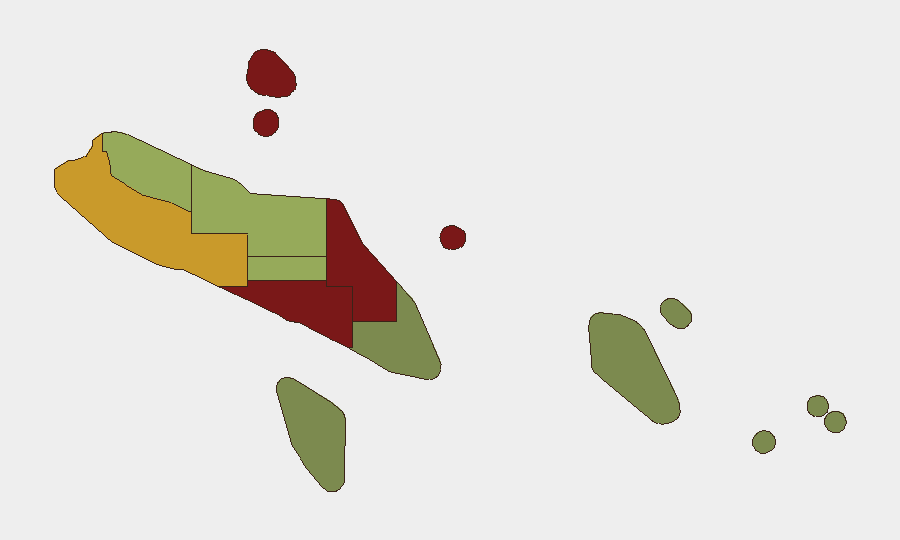
Situation Summary
Solomon Islands remains a low-intensity threat environment globally (rank #154) with a composite threat score of 9, but sub-national risk is heavily concentrated in the capital region and western provinces. Honiara (risk 92) and Guadalcanal (risk 88) dominate the risk profile, reflecting long-standing gang activity, informal settlement violence, and limited state capacity in these urban and peri-urban zones. No major security incidents or civil unrest were recorded in the week of 6–13 October 2026; maritime and transport incidents remain the primary documented events affecting personnel and logistics.
Key Developments
- Vanikoro, Temotu Province — 9–12 October 2026: The passenger vessel *MV Awka*, carrying 73 passengers and crew en route from Anuta, lost engine power and drifted offshore. Australian and French/New Caledonian aircraft delivered emergency supplies; the *Sunnine 3* (Panama-registered) and Solomon Islands patrol boat *Gizo* coordinated a successful evacuation to Vanikoro on 12 October. All personnel were safely transferred ashore without reported casualties.
- No other security-significant events verified for 6–13 October 2026. Available open-source reporting did not corroborate dated incidents in conflict, civil unrest, crime, or political instability within this window.
Highest-Risk Areas
Honiara and Guadalcanal Province together account for the majority of tracked institutional risk, driven by sustained gang violence in informal settlements (White Horse, Kukum, Rove) and limited police capacity. Malaita Province (risk 85) follows, reflecting communal tensions and historical conflict legacies that intermittently trigger localized unrest. Western Province (risk 72) presents secondary risk linked to border proximity, resource competition, and limited government presence. Risk drops sharply beyond these four zones; eastern provinces (Temotu, Rennell and Bellona) pose minimal security threats, though maritime and weather hazards remain operationally relevant.
How GeoBit Would Assist
Corporate security teams should employ AOI Monitoring & Early Warning on Honiara's high-risk settlement zones to detect emerging gang activity or civil unrest before escalation. Maritime & Aviation Tracking paired with Routing & Network Analysis enables real-time visibility of personnel movement and alternative journey planning around Honiara's congested and unsafe corridors. Intelligence & OSINT (Intel Sweep, X/Telegram monitoring, multi-language search, and sentiment analysis) will surface emerging political or communal tensions across provinces before they manifest as security incidents.
7-Day Outlook
No acute security crisis is anticipated in the coming week. Honiara remains operationally constrained by endemic gang activity and limited police presence, but no escalation drivers are evident. Seasonal maritime risk (cyclone season approaches in the South Pacific) should be factored into logistics and evacuation planning, particularly for eastern and remote provinces dependent on sea transport.
Highest-Risk Areas — Ranked
| # | State / Region | Risk |
|---|---|---|
| 1 | Honiara | 92 |
| 2 | Guadalcanal | 88 |
| 3 | Malaita | 85 |
| 4 | Western | 72 |
| 5 | Choiseul | 58 |
| 6 | Isabel | 52 |
| 7 | Central Province | 48 |
| 8 | Makira-Ulawa | 38 |
| 9 | Rennell and Bellona | 22 |
| 10 | Temotu | 18 |
Sources
Previous Weekly Briefs
A new Solomon Islands brief is written every Monday, covering the week — each with its own risk map and downloadable CSV. Use the calendar to go further back.
- October 6, 2026
- September 29, 2026
- September 22, 2026
- September 15, 2026
- September 8, 2026
- September 2, 2026
- August 31, 2026
📅 Browse past briefs by calendar →
Highlighted days have a brief. Tap a day for that day's map & analysis, or “csv” for that day's dataset ($5).
Atlas — our AI intelligence desk — emails them this snapshot personally. Nothing else, no list.