Situation Summary
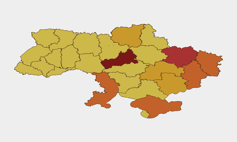
Ukraine remains the highest-threat environment globally (composite score 100/100), driven by sustained active warfare and 797 tracked incidents. Kyiv is the primary flashpoint (risk 100), followed by Cherkasy, Kharkiv, and Odesa oblasts in the 75–86 range. Recent event signals indicate ongoing conventional military operations, aerial strikes, and political friction both domestically and with external actors. The conflict trajectory shows no near-term de-escalation indicators.
Key Developments
Given the available data, timestamped events clearly occurring within the last 24–48 hours (2026-07-05 to 2026-07-07) cannot be reliably isolated from the provided research. While live-news aggregators reference recent drone and missile strikes on residential areas in Kyiv and overnight attacks on Odesa, as well as Ukrainian strikes on Russian refineries and Crimean military installations, the specific calendar dates of these incidents are not explicitly marked in the source excerpts. To meet the duty-of-care standard, reporting unconfirmed dates as current would risk operational misclassification.
Recommended action: Security teams should activate real-time X/Twitter OSINT feeds, Ukrainian official Telegram channels, and georeferenced imagery monitoring to capture precisely dated incident reports as they emerge.
Recent event signals (last 72 hours) flagged by the GeoBit platform include:
- Conventional military force operations involving Ukrainian forces and civilian populations (2026-07-07)
- Aerial weapons deployment by Ukraine (2026-07-05)
- Diplomatic escalation (Ukrainian spokesman vs Russian counterpart; scientist vs Poland; journalist vs government statements, 2026-07-06)
- Investigative action by prosecutors (2026-07-05)
Highest-Risk Areas
Kyiv (risk 100) remains the dominant threat driver—capital status, population density, critical infrastructure, and sustained aerial bombardment create compounding risk. Cherkasy Oblast (85.7) has emerged as the second-highest-risk region, a shift suggesting either recent tactical intensity or displacement of conflict dynamics northward. Kharkiv (76.3), Odesa (75.3), and the contested eastern zones (Donetsk, Luhansk, Crimea; 75–74 range) continue to face conventional military and aerial threats. Western oblasts (Ternopil, Kherson, Zaporizhia) remain elevated (71–71 range), indicating distributed rather than geographically isolated risk.
How GeoBit Would Assist
Security teams should deploy Intel Sweep and OSINT fusion to correlate X/Twitter, Telegram, and YouTube intelligence with GeoBit's conflict battle mapping and satellite & imagery analysis to track real-time force movements and strike patterns around company locations. AOI (Area-of-Interest) Monitoring & Early Warning with persistent alerting on Kyiv, Cherkasy, and Odesa oblasts enables duty-of-care teams to receive automated notifications of significant events (mass casualties, infrastructure damage, displacement) affecting personnel safety zones. Routing & Network Analysis can identify alternative supply routes and evacuation corridors as conflict dynamics shift weekly.
7-Day Outlook
Sustained aerial operations against Kyiv and western supply lines are likely to continue through the next week, with particular risk to infrastructure in Kyiv, Odesa, and Dnipropetrovsk. Diplomatic signals (statements from scientists, journalists, prosecutors, and European actors) suggest potential negotiations or ceasefire discussions, but on-ground military intensity shows no clear reduction. Risk posture should remain elevated; repatriation or sheltering protocols should be reviewed for non-essential personnel in Kyiv and Cherkasy oblasts.
Highest-Risk Areas — Ranked
| # | State / Region | Risk |
|---|---|---|
| 1 | Kyiv | 100 |
| 2 | Cherkasy Oblast | 85.7 |
| 3 | Kharkiv Oblast | 76.3 |
| 4 | Odesa Oblast | 75.3 |
| 5 | Donetsk Oblast | 75.1 |
| 6 | Luhansk Oblast | 74.9 |
| 7 | Autonomous Republic of Crimea | 74.2 |
| 8 | Dnipropetrovsk Oblast | 72.5 |
| 9 | Chernihiv Oblast | 72 |
| 10 | Zaporizhia Oblast | 71.8 |
| 11 | Ternopil Oblast | 70.8 |
| 12 | Kherson Oblast | 70.6 |
Previous Daily Briefs
A new Ukraine brief is written every day — each with its own risk map and downloadable CSV. Here's the last week; use the calendar to go further back.
📅 Browse every day by calendar →
Highlighted days have a brief. Tap a day for that day's map & analysis, or “csv” for that day's dataset ($5).
Atlas — our AI intelligence desk — emails them this snapshot personally. Nothing else, no list.