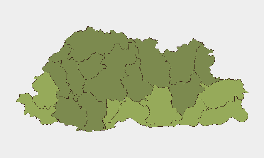
Situation Summary
Bhutan remains a low-threat environment with no confirmed security incidents, unrest, crime, or infrastructure disruptions reported in the last 24–48 hours. The country's composite threat score of 3 reflects sustained stability across most of its territory. No acute developments or travel-risk events have been detected in major urban centers or transport corridors, and open-source monitoring confirms routine governance and development activity with no indicators of imminent destabilization.
Key Developments
No discrete security, crime, civil disorder, or infrastructure incidents meeting recency and location-specificity criteria have been confirmed in Bhutan in the last 24–48 hours. Open-source feeds, social media monitoring, and Bhutan Broadcasting Service (BBS) coverage show no reports of protests, violent crime, major accidents, or travel disruptions in the immediate monitoring window. Regional incidents in adjacent areas—including unrest in Sunsari district (Nepal) and landslides on the Mugling–Narayangadh highway (Nepal)—remain geographically isolated with no confirmed spillover into Bhutanese territory or material impact on cross-border movement as of the latest reporting.
Highest-Risk Areas
Southern border districts drive Bhutan's sub-national risk ranking. Samtse District (risk 58), Sarpang District (55), and Haa District (52) occupy the top three positions, likely reflecting proximity to international borders, historic cross-border security concerns, and geographical isolation that can complicate rapid response or situational awareness. Samdrup Jongkhar, Pemagatshel, and Tsirang districts follow with scores in the 45–50 range, suggesting sustained lower-level vulnerabilities related to border management, limited infrastructure, and transnational movement. Northern and central districts (Gasa, Lhuntse, Wangdue Phodrang) record materially lower risk scores, indicating more stable conditions and denser governance presence.
How GeoBit Would Assist
Security teams with personnel or assets in Bhutan would deploy GeoBit's AOI (Area-of-Interest) Monitoring & Early Warning capability to maintain persistent watch over southern border districts and major transport corridors, with automated alerting on civil disorder, cross-border movement anomalies, or infrastructure disruptions. Intel Sweep and multi-language OSINT fusion—drawing from BBS, social media, regional news, and government sources—would provide real-time situational awareness of any emerging incidents, protest activity, or crime trends. Routing & Network Analysis would enable contingency planning for personnel movement, identifying alternative routes and safe corridors during any future disruption.
7-Day Outlook
No indicators of near-term security deterioration are present; Bhutan's political and security environment is expected to remain stable over the coming week. Seasonal weather patterns and routine border management will remain the primary operational variables for corporate movements. Continued monitoring of southern districts and regional developments in Nepal and India is warranted as a standard precaution, though no elevated risk to Bhutanese territory is forecast.
Highest-Risk Areas — Ranked
| # | State / Region | Risk |
|---|---|---|
| 1 | Samtse District | 58 |
| 2 | Sarpang District | 55 |
| 3 | Haa District | 52 |
| 4 | Pemagatshel District | 50 |
| 5 | Samdrup Jongkhar District | 48 |
| 6 | Tsirang District | 45 |
| 7 | Zhemgang District | 42 |
| 8 | Trashigang District | 40 |
| 9 | Mongar District | 38 |
| 10 | Gasa District | 35 |
| 11 | Lhuntse District | 32 |
| 12 | Wangdue Phodrang District | 30 |
Sources
Previous Daily Briefs
A new Bhutan brief is written every day — each with its own risk map and downloadable CSV. Here's the last week; use the calendar to go further back.
📅 Browse every day by calendar →
Highlighted days have a brief. Tap a day for that day's map & analysis, or “csv” for that day's dataset ($5).
Atlas — our AI intelligence desk — emails them this snapshot personally. Nothing else, no list.