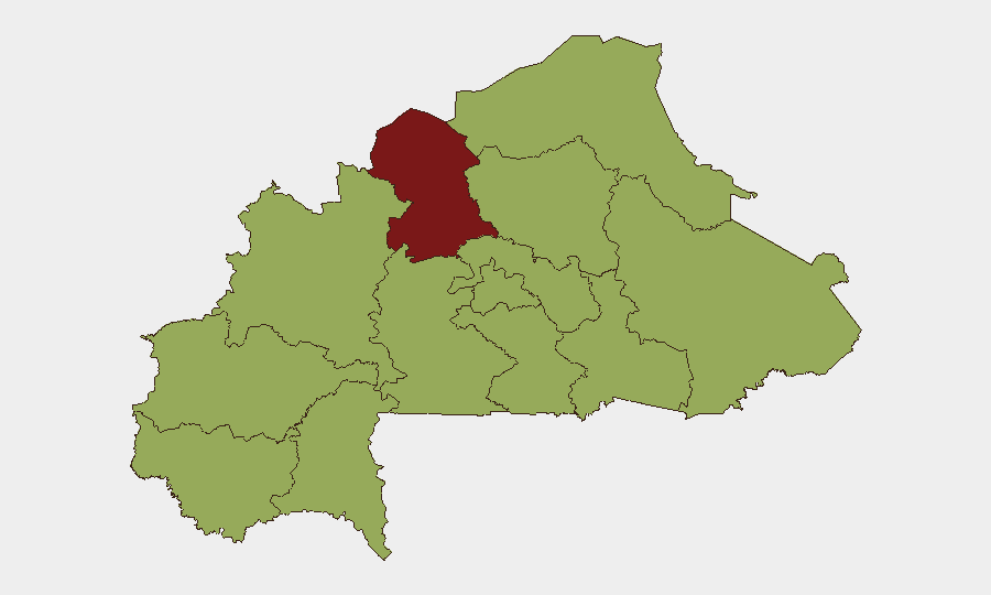
Situation Summary
Burkina Faso remains at composite threat level 74 (#20 globally), driven primarily by sustained jihadist insurgency across the Sahel and eastern regions. The most recent verifiable security activity occurred on June 30, involving coordinated multi-location attacks in the tri-border Sirba–Liptako zone, met by Burkinabe military counter-operations; no new confirmed incidents have been independently corroborated in the 24–48 hours prior to this brief. The June 26 severance of diplomatic relations with France compounds political and operational risk, particularly for foreign nationals and expatriate-dependent security cooperation.
Key Developments
- 2026-07-05 · Conventional Military Force (Niger–Burkina Faso border): Signal data indicate active military posturing or movement along the Niger–Burkina Faso border; exact nature and scale remain unconfirmed by open sources, but warrant close monitoring given regional tension and porous frontier conditions.
- 2026-07-03 · Terrorist Public Statement: Unconfirmed jihadist claims or statements circulated; no new attack attribution or tactical detail independently verified to date.
- 2026-07-03 · Diplomatic Relations (Burkina Faso): Follow-on diplomatic signaling related to the June 26 France rupture; implications for consular support, security-cooperation agreements, and foreign-presence policy remain in flux.
- 2026-06-30 · Multi-Location Coordinated Attacks (Gayéri, Solhan, Sebba, Sirba–Liptako): Burkinabe military reported coordinated insurgent assaults across Tapoa, Yagha, and Sirba provinces, claiming neutralization of 400+ combatants, recovery of 250+ motorcycles, and 353 weapons; operations reportedly included airstrikes and ground combat, underscoring sustained jihadist capability and coordination in the east.
- 2026-06-26 · France Diplomatic Rupture: Ouagadougou junta formally severed ties with France, alleging subversive activities; ongoing implications for political stability, foreign-security partnerships, and expat duty-of-care posture.
Highest-Risk Areas
The North region (composite score 82) remains the single highest-risk area, reflecting uncontrolled jihadist presence, weak state capacity, and supply-line vulnerability. The East (55.8) ranks second and is the immediate focal point of active military operations (Gayéri, Solhan, Sebba, Sirba–Liptako), where June 30 events demonstrated coordinated multi-unit insurgent attacks and continued militant mobility. All other regions cluster at scores 52–52, indicating a broad, nationwide diffusion of risk rather than geographic containment; this suggests that the threat is not localized but embedded across the sahel-zone provinces and accessible approaches to the capital. Personnel and assets in the North and East face the highest probability of contact with active combat and jihadist movement; operations in Centre and Central-North should prepare for rapid escalation given the risk-score plateau across the interior.
How GeoBit Would Assist
Security teams would employ AOI Monitoring & Early Warning to track the North and East regions (and border zones) for fresh attack signals, jihadist movement, and military repositioning with low-latency alerting. Battle Mapping and Force Structure tracking would clarify Burkinabe military posture and capacity to respond to the June 30–style coordinated assaults and any Niger border activity. Network & Actor Analysis and OSINT Fusion (X/Telegram OSINT, multi-language search) would provide real-time monitoring of jihadist claims, tactical chatter, and diplomatic-friction narratives, enabling rapid duty-of-care decision-making for expat populations and asset exposure.
7-Day Outlook
The absence of new confirmed incidents in the last 48 hours does not signal a de-escalation; rather, the June 30 coordinated attacks and the June 26 France rupture are likely to sustain elevated operational tempo and political volatility through the near term. The unconfirmed Niger border military signals warrant close watch, as any cross-border escalation would materially increase risk to eastern provinces and could trigger secondary displacement or humanitarian crises affecting security operations.
Highest-Risk Areas — Ranked
| # | State / Region | Risk |
|---|---|---|
| 1 | North | 82 |
| 2 | East | 55.8 |
| 3 | Upper-Basins | 52 |
| 4 | Boucle du Mouhoun | 52 |
| 5 | Central-West | 52 |
| 6 | Central-South | 52 |
| 7 | Central-East | 52 |
| 8 | Waterfalls | 52 |
| 9 | Southwest | 52 |
| 10 | Sahel | 52 |
| 11 | Central-North | 52 |
| 12 | Centre | 52 |
Sources
Previous Daily Briefs
A new Burkina Faso brief is written every day — each with its own risk map and downloadable CSV. Here's the last week; use the calendar to go further back.
📅 Browse every day by calendar →
Highlighted days have a brief. Tap a day for that day's map & analysis, or “csv” for that day's dataset ($5).
Atlas — our AI intelligence desk — emails them this snapshot personally. Nothing else, no list.