Situation Summary
Iceland remains a low-threat environment with a composite threat score of 28 and no discrete security events in the current tracking window. Recent 24–48-hour activity is dominated by routine law-enforcement incidents (drunk driving, group altercations, one assault arrest) and two operational incidents (mink farm breach, Coast Guard boarding of protest vessel). The Capital Region accounts for the majority of flagged activity and elevated risk scoring; other regions show minimal security friction.
Key Developments
- Mosfellsdalur, southwest Iceland (2026-08-03, early morning): Several hundred mink escaped from the Dalbú farm; police and regulatory agencies responded to investigate the breach mechanism. No injuries or secondary incidents reported, though environmental and agricultural impact under assessment.
- Reykjavík harbour, Capital Region (2026-08-03, morning): The protest vessel *Bandero*, associated with anti-whaling activist Paul Watson's organization, was brought into harbour under Coast Guard control following a boarding operation the previous night. Coast Guard cited safety concerns regarding the whaling vessel *Hvalur 9*. No violence or injuries reported during boarding or transit.
- Central Reykjavík (2026-08-03, ~05:00): A group fight (hópslagsmál) resulted in police detention of two individuals. Contributing factor to elevated police activity overnight but no serious injuries documented.
- Kópavogur/Breiðholt area, Capital Region (2026-08-03, evening): One person arrested on suspicion of assault following a violent incident report. Standard police response; no mass casualty or security escalation.
- Capital Region roads (2026-08-03, evening–night): Multiple drunk-driving incidents detected; police conducted stops and substance seizures across the Reykjavík metropolitan area and South Iceland. Routine traffic enforcement outcome.
- Vestmannaeyjar, South Iceland (2026-08-02/03, weekend): Þjóðhátíð National Festival opening recorded unusually calm conditions with only minor alcohol-related interventions (three intoxicated individuals, two underage-drinking incidents) and one helicopter evacuation for a leg injury. No serious public-order incidents.
- North Iceland road network (2026-08-03, ongoing): Vegagerðin road alerts introduced new axle weight restrictions on several sections. Main tourist and Ring Road corridors remain open; impact limited to freight and heavy-vehicle routing.
Highest-Risk Areas
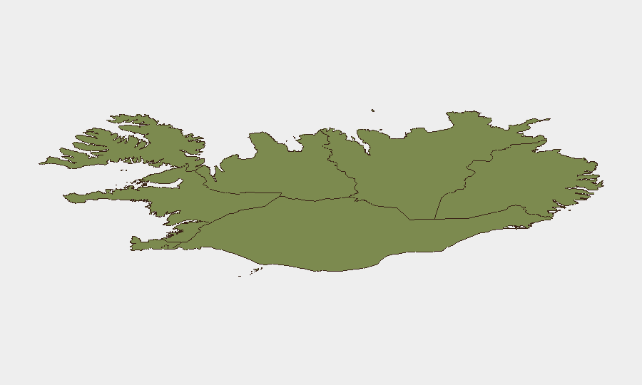
The Capital Region (Reykjavík metropolitan area) drives Iceland's composite risk score at 24, reflecting higher density of law-enforcement activity, transient populations, and operational incidents (protest vessel, drunk driving, altercations). The Southern Peninsula and Southern Region (risk 12 and 11 respectively) show secondary elevation, primarily tied to festival activity and routine traffic enforcement. Remaining regions—Western, Westfjords, Northwestern, and Northeastern—register minimal risk (6–9), indicating highly localized and contained security activity outside the capital zone.
How GeoBit Would Assist
Security teams with personnel or assets in Iceland should employ AOI Monitoring & Early Warning on the Capital Region to detect clustering of law-enforcement incidents or protest activity; Maritime & Aviation tracking to monitor Coast Guard operations and vessel movements in territorial waters; and OSINT fusion & multi-language search to corroborate incident reports and assess secondary impacts (e.g., mink farm environmental risk, festival safety trends). Real-time road alerts via Routing & Network Analysis support contingency planning for personnel transiting North Iceland.
7-Day Outlook
No significant escalation is anticipated. Routine law-enforcement activity and festival closures will likely normalize within 48–72 hours. The mink-farm investigation and ongoing Coast Guard custody of *Bandero* may generate administrative or legal proceedings but pose no immediate security threat to corporate personnel or assets. Weather, road conditions, and occasional drunk-driving enforcement will remain the primary operational considerations.
Highest-Risk Areas — Ranked
| # | State / Region | Risk |
|---|---|---|
| 1 | Capital Region | 24 |
| 2 | Southern Peninsula | 12 |
| 3 | Southern Region | 11 |
| 4 | Eastern Region | 10 |
| 5 | Western Region | 9 |
| 6 | Westfjords Region | 8 |
| 7 | Northwestern Region | 7 |
| 8 | Northeastern Region | 6 |
Sources
Previous Daily Briefs
A new Iceland brief is written every day — each with its own risk map and downloadable CSV. Here's the last week; use the calendar to go further back.
📅 Browse every day by calendar →
Highlighted days have a brief. Tap a day for that day's map & analysis, or “csv” for that day's dataset ($5).
Atlas — our AI intelligence desk — emails them this snapshot personally. Nothing else, no list.