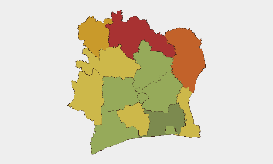
Situation Summary
Ivory Coast remains at moderate overall risk (composite score 25; #69 globally), with no tracked security events in the past 24 hours. However, underlying intercommunal tensions and localized violence persist in the north and northeast, where land disputes and informal-sector conflicts continue to drive sporadic incidents. The security environment is characterized by friction points rather than systemic instability, but northern frontier zones warrant sustained monitoring given their isolation and weak state presence.
Key Developments
No new incidents confirmed in the last 24–48 hours. The most recent tracked event—the 12 August arrest of 18 individuals in Abobo on charges including murder, public disorder, and illegal weapons possession—reflects ongoing judicial response to earlier unrest but does not constitute a new security incident as of 17 August 2026. Live web research yielded no genuinely current (16–17 August) security or unrest reporting from Ivory Coast; all recent material recovered dates to 4–15 August and falls outside the 24–48 hour window.
For operational context, the Kossandji intercommunal clashes (Alepe Department, southeast) of 4 August 2026—which killed 6–7 persons and involved land disputes between Akye and Lobi/Mos communities—and the 4 August killing of customs officer Sous-chef Coulibaly Lamtou Aimé in a taxi-driver altercation remain the substantive recent security events, but both are now 12+ days old.
Highest-Risk Areas
Northern and northeastern districts drive the composite threat ranking. Savanes, Zanzan, Denguélé, and Comoé districts (scores 78, 75, 72, 70 respectively) cluster in the top tier, reflecting persistent land disputes, weak state security reach, porous border zones, and informal-sector friction (customs enforcement, transport-sector clashes). These regions experience the highest frequency of intercommunal and transactional violence. By contrast, Abidjan (risk 45) and the southern-central districts (Lacs, Bas-Sassandra, Vallée du Bandama; scores 48–55) carry substantially lower risk, indicating that threat concentration remains distinctly geographic rather than nationwide. Corporate and duty-of-care teams with assets or personnel in Savanes and Zanzan should prioritize localized risk briefing and alternative routing.
How GeoBit Would Assist
Security teams monitoring Ivory Coast should deploy AOI Monitoring & Early Warning on the highest-risk northern districts, with alert thresholds set for intercommunal clashes, transport-sector incidents, and customs-related violence. Intel Sweep and multi-language OSINT (including French-language local sources and Telegram/Twitter) provide 24–48 hour event verification and location specificity necessary for duty-of-care incident response. Routing & Network Analysis tools support safe-passage planning for personnel traveling between Abidjan and northern operations, identifying alternative corridors around known friction zones. Once live search access is restored, targeted conflict and crime search will surface emerging trends in land disputes and informal-sector violence by sub-national region.
7-Day Outlook
No imminent escalation or security crisis is indicated. However, the pattern of intercommunal land disputes (Kossandji 4 August) and informal-sector altercations (customs/transport 4 August) suggests ongoing low-level friction in northern and frontier zones that will likely produce sporadic incidents over the coming week. Operational risk in Savanes and Zanzan districts remains elevated and should be monitored continuously; southern and central regions remain stable.
Highest-Risk Areas — Ranked
| # | State / Region | Risk |
|---|---|---|
| 1 | Savanes District | 78 |
| 2 | Zanzan District | 75 |
| 3 | Denguélé District | 72 |
| 4 | Comoé District | 70 |
| 5 | Montagnes District | 68 |
| 6 | Woroba District | 65 |
| 7 | Gôh-Djiboua District | 60 |
| 8 | Sassandra-Marahoué District | 58 |
| 9 | Vallée du Bandama District | 55 |
| 10 | Bas-Sassandra District | 52 |
| 11 | Lacs District | 48 |
| 12 | Abidjan | 45 |
Sources
Previous Daily Briefs
A new Ivory Coast brief is written every day — each with its own risk map and downloadable CSV. Here's the last week; use the calendar to go further back.
- August 16, 2026
- August 14, 2026
- August 13, 2026
- August 12, 2026
- August 11, 2026
- August 10, 2026
- August 9, 2026
📅 Browse every day by calendar →
Highlighted days have a brief. Tap a day for that day's map & analysis, or “csv” for that day's dataset ($5).
Atlas — our AI intelligence desk — emails them this snapshot personally. Nothing else, no list.