Situation Summary
Maldives remains a low-threat environment (global rank #169, composite score 4) with no tracked security events of national significance as of 2026-08-08. However, the country is currently managing dual operational incidents—an active maritime search-and-rescue operation following a vessel capsizing near Gaafaru, and a measles outbreak in Malé affecting public health operations. Risk is concentrated in the capital region and northern atolls, driven by population density and maritime transit volume rather than civil unrest or political instability.
Key Developments
- 2026-08-06/07, near Kaafu Gaafaru: Landing craft capsized in rough seas with two expatriate crew members missing; MNDF, coast guard, and police conducted ongoing search-and-rescue operations with drone and aircraft support. Vessel remains unlocated.
- 2026-08-07, off Kaafu Maafushi: Live-aboard safari vessel *Princess Laala* ran aground after breaking anchor and striking outer breakwater; incident documented via social media. Status of passengers and structural damage not confirmed in available reporting.
- 2026-08-07, between Kaafu Himmafushi and Kaafu Girifushi: MNDF issued maritime hazard warning for an unlit metal barge drifting eastward, creating navigation obstruction for commercial and tourism vessels.
- 2026-08-02–08, Malé: Health Protection Agency reports 121 confirmed measles cases; vaccination campaigns and case isolation protocols active. Outbreak trajectory and vaccination coverage rates not specified in current reporting.
- 2026-08-07, Hulhumalé Phase 1: Police responded to apartment disturbance and arrested intoxicated individuals; no broader civil order implications indicated.
- 2026-08-07/08, Malé/Hulhumalé/Vilimalé: Waste management disruption at Thilafushi (fire-related) caused reduced construction-waste collection; normal operations resuming.
Highest-Risk Areas
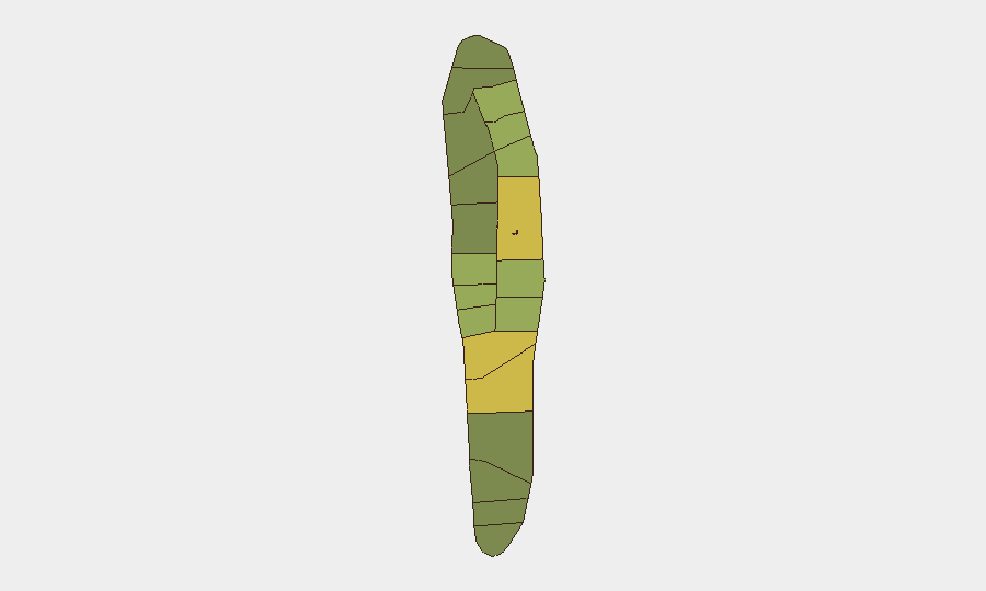
Malé and Malé Atoll drive the country's risk profile (scores 85 and 68 respectively), reflecting concentration of population, government services, tourism infrastructure, and maritime traffic. Northern atolls—Hadhdhunmathi, Kolhumadulu, Felidhu, and Mulaku—carry elevated scores (65–55) tied to inter-island ferry routes, fishing operations, and resort logistics; recent maritime incidents near Gaafaru and Maafushi reinforce vulnerability to weather-dependent supply and personnel movement. Southern atolls score lower (40–42), indicating reduced operational risk for corporate presence.
How GeoBit Would Assist
Teams with personnel or assets in Maldives should employ Maritime & Aviation tracking to monitor vessel movements and geofence high-risk transit corridors near Gaafaru and Maafushi, and AOI Monitoring & Early Warning to track measles case clusters and health-system capacity in Malé in real time. Environmental & Health intelligence would support duty-of-care protocols around disease exposure and outbreak trajectory, while GIS & Spatial Analysis combined with Routing & Network Analysis enables alternative logistical planning if maritime incidents disrupt primary supply or personnel routes.
7-Day Outlook
The Gaafaru search-and-rescue operation is likely to conclude or transition to recovery within 72 hours based on standard maritime timelines; no secondary maritime incidents have been reported. Measles cases are expected to plateau as vaccination campaigns continue, but isolation protocols may intermittently affect staffing in Malé. Overall threat trajectory remains stable; no escalation to civil unrest, security force activity, or political instability is indicated.
Highest-Risk Areas — Ranked
| # | State / Region | Risk |
|---|---|---|
| 1 | Malé | 85 |
| 2 | Malé Atoll | 68 |
| 3 | Hadhdhunmathi | 65 |
| 4 | Kolhumadulu | 60 |
| 5 | Felidhu Atoll | 58 |
| 6 | Mulaku Atoll | 55 |
| 7 | Faadhippolhu | 52 |
| 8 | South Miladhunmadulu | 48 |
| 9 | North Miladhunmadulu | 45 |
| 10 | South Nilandhe Atoll | 44 |
| 11 | North Nilandhe Atoll | 42 |
| 12 | South Ari Atoll | 40 |
Sources
Previous Daily Briefs
A new Maldives brief is written every day — each with its own risk map and downloadable CSV. Here's the last week; use the calendar to go further back.
📅 Browse every day by calendar →
Highlighted days have a brief. Tap a day for that day's map & analysis, or “csv” for that day's dataset ($5).
Atlas — our AI intelligence desk — emails them this snapshot personally. Nothing else, no list.