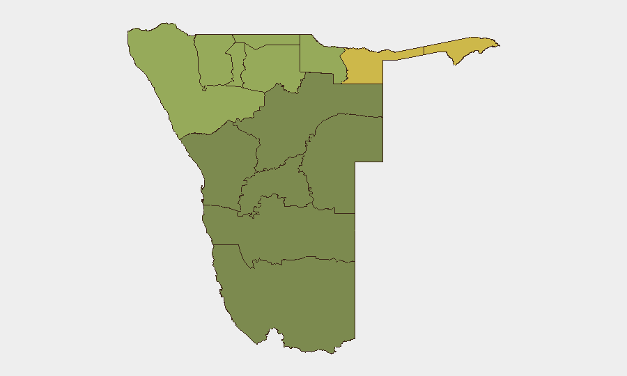
Situation Summary
Namibia remains a relatively low-threat environment at the national level (composite threat score 14; rank #109 globally) with no tracked large-scale civil unrest, armed conflict, or infrastructure disruption. Current security developments are limited to localized violent crime and traffic incidents reported through standard police channels. The security trajectory remains stable, though northern border regions—particularly Zambezi, Kavango East, and Kavango West—continue to register elevated sub-national risk scores warranting focused monitoring.
Key Developments
- Okahandja, Otjozondjupa Region (19 August 2026, incident 18 August): Fatal spear attack following dispute over stolen cellphone; 26-year-old male fatality; four suspects aged 17, 25, 27, and 31 implicated and under police investigation.
- Trans-Caprivi Highway, Zambezi Region – dual hit-and-run incidents (18 August 2026 report, incidents 17 August): Two separate pedestrian-vehicle collisions with fleeing drivers on the same highway near Omega 3 and toward Divundu; both victims struck in evening hours; police investigations active on both cases.
- Otjiwarongo, Otjozondjupa Region (17 August 2026 report, arrest 16 August, alleged incident 12 August): Arrest of 43-year-old male at guesthouse in connection with alleged rape of 15-year-old minor; case under police handling.
- Otavi district, Otjozondjupa Region (ongoing reference as of 19 August; incident 14 August): Suspected suicide of 26-year-old male wanted in connection with rape and murder of 16-year-old female; body located following apparent self-inflicted gunshot wound while evading arrest.
- National law enforcement activity (statement carried through 19 August): Namibian Police leadership publicly characterized Operation ZAKAWE crime-suppression initiative as successful, reflecting ongoing enforcement tempo but not indicative of new discrete security incidents in the 48-hour window.
Highest-Risk Areas
Zambezi Region dominates sub-national risk (score 68), driven by border permeability, remote infrastructure, and repeat traffic incidents on critical transit corridors such as the Trans-Caprivi Highway. Kavango East (62) and Kavango West (58) follow, reflecting similar northern-border exposure and limited state presence. These three regions account for the majority of elevated risk; by contrast, central and southern regions (Hardap, Omaheke, Erongo) register materially lower threat profiles. Risk in northern zones stems from geographic isolation, cross-border movement, limited policing capacity, and prevalence of informal dispute resolution rather than acute conflict or organized armed activity.
How GeoBit Would Assist
Security teams with personnel or assets in Namibia should leverage AOI Monitoring & Early Warning to maintain persistent watch on Zambezi and Kavango regions, with alerting configured for violent crime, road incidents, and border-crossing activity. Intel Sweep and multi-language OSINT capabilities enable continuous monitoring of Namibian police reports, local media, and social platforms to detect emerging threats before they escalate. Risk & Threat Assessment and Routing & Network Analysis would support both long-term strategic posture and tactical journey planning for staff transiting high-risk northern corridors.
7-Day Outlook
No indicators suggest imminent large-scale instability or organized violence in Namibia over the coming week. Localized violent crime will likely persist at current baseline levels; the Trans-Caprivi Highway should remain flagged for ongoing traffic safety hazards. Northern regions will continue to require standard duty-of-care protocols and monitoring, but no escalation is forecast absent new triggering events.
Highest-Risk Areas — Ranked
| # | State / Region | Risk |
|---|---|---|
| 1 | Zambezi | 68 |
| 2 | Kavango East | 62 |
| 3 | Kavango West | 58 |
| 4 | Kunene Region | 52 |
| 5 | Oshikoto | 48 |
| 6 | Ohangwena | 45 |
| 7 | Omusati | 42 |
| 8 | Oshana | 40 |
| 9 | Otjozondjupa | 35 |
| 10 | Erongo Region | 32 |
| 11 | Hardap | 28 |
| 12 | Omaheke | 25 |
Sources
Previous Daily Briefs
A new Namibia brief is written every day — each with its own risk map and downloadable CSV. Here's the last week; use the calendar to go further back.
- August 17, 2026
- August 15, 2026
- August 13, 2026
- August 11, 2026
- August 9, 2026
- August 7, 2026
- August 5, 2026
📅 Browse every day by calendar →
Highlighted days have a brief. Tap a day for that day's map & analysis, or “csv” for that day's dataset ($5).
Atlas — our AI intelligence desk — emails them this snapshot personally. Nothing else, no list.