Situation Summary
Norway remains a low-threat environment globally (rank #49, composite score 35) with no tracked major security events as of 17 August 2026. However, sub-national risk concentration in Oslo (68) and surrounding eastern regions reflects elevated localized incidents—recent kidnapping, violence, and armed robbery—alongside ongoing strategic border-security activity related to illegal Russian crossings. Infrastructure disruptions (natural gas processing) and wildlife-enforcement actions in remote Svalbard have caused operational friction but no direct public-safety threat. The overall trajectory remains stable with manageable, geographically bounded risk.
Key Developments
- Svalbard, 17 August 2026 – Governor of Svalbard imposed a 50,000 NOK fine for intentional disturbance of a protected polar bear via maritime foghorn earlier in August. Signals strict environmental-enforcement control in the archipelago and potential liability for travelers engaged in wildlife interaction.
- Kollsnes natural gas processing plant (western Norway), 16–17 August 2026 – Unplanned shutdown reduced daily output by 12 million m³; separate planned suspension at Kårstø gas field (17–18 August) adds 5 million m³ reduction. No sabotage indicated; technical/operational impact on regional energy supply.
- Norwegian Sea, 17 August 2026 (incident timing ambiguous; reported update only) – Russian Tu‑142 aircraft conducted unsafe low-altitude approach to HMS Prince of Wales, deploying surveillance devices. Illustrates ongoing NATO–Russia military-security friction in Norwegian waters; exact timing of incident unclear from available reporting.
- Lindeberg, Oslo, 14 August 2026 – Two men arrested following unlawful deprivation of liberty; related to broader violence cluster in Oslo area. Part of pattern driving elevated capital-region risk score.
- Russian–Norwegian border, 14 August 2026 – Border guards apprehended a Russian serviceman (reportedly Ukraine-war veteran) following illegal crossing near Grens. Reflects ongoing cross-border security activity and vetting of military-background individuals.
- Lesja (Innlandet), 11 August 2026 – A dangerous individual escaped an institution with a knife; police manhunt underway. Status of containment not confirmed in available reporting.
Highest-Risk Areas
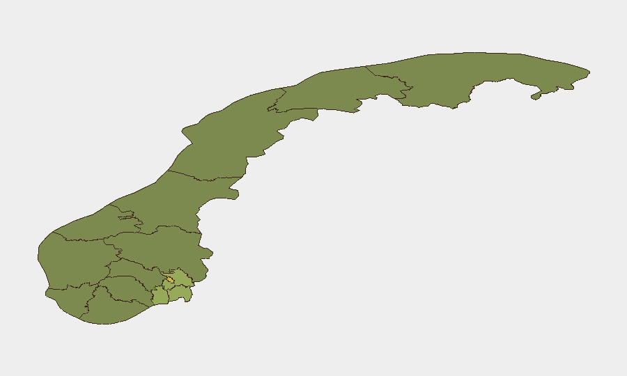
Oslo (risk 68) and Akershus (52) dominate the sub-national ranking and drive national risk elevation, driven by clustering of kidnapping, violence, and armed robbery in the past 10 days. Østfold and Vestfold counties follow, forming an eastern-corridor concentration reflecting urban density, organized-crime activity, and transit vulnerability. Rogaland and Buskerud remain elevated but show lower event density. Northern and western regions (Møre og Romsdal, Innlandet) carry minimal tracked risk despite the Lesja institutional escape; remoteness and lower population density reduce incident visibility rather than threat.
How GeoBit Would Assist
Security teams protecting personnel or assets in Norway should deploy AOI Monitoring & Early Warning on Oslo, Akershus, and Østfold to detect emerging crime clusters and violence hotspots in real time. Intel Sweep (global event feeds, multi-language OSINT, sentiment analysis) paired with Network & Actor Analysis enables tracking of organized-crime networks and border-crossing activity feeding the kidnapping and armed-robbery pattern. Routing & Network Analysis supports dynamic journey planning around high-risk urban corridors and infrastructure disruptions (e.g., gas-plant outages affecting supply chains).
7-Day Outlook
No significant escalation is anticipated. Arctic Race of Norway cycling events (stages concluded 13–15 August) have cleared road closures; minor policing and crowd-management activity may persist. Border security and kidnapping investigations will likely continue with no broad public-safety implications. Infrastructure normalization (gas processing) is expected within 48 hours unless technical complications arise.
Highest-Risk Areas — Ranked
| # | State / Region | Risk |
|---|---|---|
| 1 | Oslo | 68 |
| 2 | Akershus | 52 |
| 3 | Østfold | 48 |
| 4 | Vestfold | 42 |
| 5 | Rogaland | 38 |
| 6 | Buskerud | 35 |
| 7 | Trøndelag | 32 |
| 8 | Telemark | 28 |
| 9 | Vestland | 27 |
| 10 | Agder | 26 |
| 11 | Møre og Romsdal | 22 |
| 12 | Innlandet | 20 |
Sources
Previous Daily Briefs
A new Norway brief is written every day — each with its own risk map and downloadable CSV. Here's the last week; use the calendar to go further back.
- August 16, 2026
- August 15, 2026
- August 14, 2026
- August 13, 2026
- August 12, 2026
- August 11, 2026
- August 10, 2026
📅 Browse every day by calendar →
Highlighted days have a brief. Tap a day for that day's map & analysis, or “csv” for that day's dataset ($5).
Atlas — our AI intelligence desk — emails them this snapshot personally. Nothing else, no list.