Situation Summary
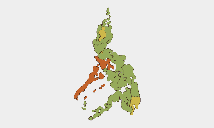
The Philippines remains a composite moderate-risk environment (rank #36 globally, score 63) with 97 tracked threat events, characterized by persistent volcanic hazards, localized armed violence in Mindanao urban centers, and ongoing law-enforcement operations against organized crime and wanted suspects. Recent 24–48-hour reporting shows active criminal activity in Cotabato City and continued volcanic unrest at three major systems (Mayon, Kanlaon, Taal), alongside isolated infrastructure threats. The threat picture is stable but fragmented across geography—concentrated in Mimaropa, Cordillera, Davao, and Metro Manila—with little indication of imminent nationwide escalation, though demonstrations are flagged as a developing risk factor in the capital.
Key Developments
- Cotabato City, Maguindanao del Norte (Friday–Sunday, 15–17 July): Series of gun attacks killed four people and wounded seven across multiple barangays. Police and LGU have intensified checkpoints and patrols in response, indicating sustained urban armed-violence risk in a strategic southern city.
- Mayon Volcano, Albay (ongoing through 17 July): Phivolcs confirmed 192 consecutive days of effusive lava flows and Strombolian activity at Alert Level 3, with active exclusion zones affecting transport routes and nearby communities in Bicol Region.
- Kanlaon Volcano, Negros Island (within last 24 hours): Phivolcs recorded 26 volcanic earthquakes and sustained ground inflation at Alert Level 2, with sulfur-dioxide emissions at 845 tons/day and steam plumes to 500 meters, posing aviation and ground-travel hazards.
- Tadian, Mountain Province (14 July): Philippine National Police arrested the region's second-most wanted individual on outstanding warrants, reflecting active law-enforcement operations in Cordillera Administrative Region.
- Kolambugan, Lanao del Norte (13 July, reported last 24–48h): Police seized approximately ₱7.2 million in suspected smuggled cigarettes and arrested two individuals at a checkpoint, indicating trafficking-interdiction activity in Mindanao.
- Malolos City, Bulacan (Monday, bomb-threat hoax): A bomb threat against the Regional Trial Court forced evacuation and temporary judicial closure; police K9 units cleared the facility and declared the threat unfounded, underscoring infrastructure-security concerns in the NCR periphery.
- Taal Volcano, Batangas (mid-week update, within 48h): Sulfur-dioxide emissions have declined to yearly lows while Alert Level remains at 1 (abnormal), indicating reduced but persistent unrest in a volcano proximate to Metro Manila commuter zones.
Highest-Risk Areas
Mimaropa (73.8) and Cordillera (63.5) drive the highest composite risk, with Davao (61.1) and Metro Manila (60) following closely. Mimaropa's elevation reflects multi-actor resource conflicts and indigenous-rights tensions documented in recent event signals; Cordillera combines armed criminality with law-enforcement intensity. Davao and Metro Manila anchor urban violence, infrastructure threats, and mass-gathering risk. Southern Mindanao (Soccsksargen, Zamboanga, Bangsamoro) registers elevated but moderately dispersed risk owing to persistent military-insurgent activity and localized gang violence, as emphasized in FCDO travel warnings.
How GeoBit Would Assist
Security teams would employ AOI Monitoring & Early Warning to track volcanic activity (Mayon, Kanlaon, Taal) and alert on exclusion-zone changes or ashfall affecting staff and supply chains. Conflict & Military and Network & Actor Analysis capabilities would map ongoing armed-violence hotspots (Cotabato City, Mindanao) and track wanted-person arrests to anticipate retaliation or organized-crime displacement. OSINT fusion and multi-language search would identify emerging demonstration plans in Metro Manila and regional flashpoints ahead of public disclosure.
7-Day Outlook
Volcanic hazards will remain static or gradual; Mayon and Kanlaon pose the highest infrastructure risk to Bicol and Negros respectively. Armed violence in Cotabato City is expected to stabilize under increased police presence, but organized-crime and tribal tensions suggest recurrence risk. Planned demonstrations in Metro Manila warrant close calendar and social-media monitoring to anticipate disruption windows.
Highest-Risk Areas — Ranked
| # | State / Region | Risk |
|---|---|---|
| 1 | Mimaropa | 73.8 |
| 2 | Cordillera Administrative Region | 63.5 |
| 3 | Davao Region | 61.1 |
| 4 | Metro Manila | 60 |
| 5 | Soccsksargen | 58.1 |
| 6 | Negros Island Region | 54.5 |
| 7 | Zamboanga Peninsula | 52.8 |
| 8 | Western Visayas | 45 |
| 9 | Ilocos Region | 44.4 |
| 10 | Cagayan Valley | 44.4 |
| 11 | Central Visayas | 44.4 |
| 12 | Bangsamoro | 43.8 |
Sources
Previous Daily Briefs
A new Philippines brief is written every day — each with its own risk map and downloadable CSV. Here's the last week; use the calendar to go further back.
📅 Browse every day by calendar →
Highlighted days have a brief. Tap a day for that day's map & analysis, or “csv” for that day's dataset ($5).
Atlas — our AI intelligence desk — emails them this snapshot personally. Nothing else, no list.