Situation Summary
Serbia remains at moderate composite threat level (rank #87 globally, score 19) with civil unrest as the primary risk driver. Recent developments indicate a spike in protest activity and isolated violence incidents, compounded by significant wildfire emergencies affecting infrastructure and travel corridors. The security environment is stable relative to regional comparators but characterized by underlying political tension and localized crowd-control risks, particularly in Central Serbia.
Key Developments
- Belgrade, Ušće Park — 23 August 2026: Students have called for an "eco riot" protest scheduled for Sunday afternoon, creating civil-unrest and crowd-control risks in central Belgrade with likely traffic and transport disruption.
- Deliblatska Peščara nature reserve (80 km southeast of Belgrade) — 21–22 August 2026: Serbia activated the EU Civil Protection Mechanism as a major wildfire burned in the reserve. Firefighting operations indicate significant infrastructure and environmental emergency with potential travel corridor impacts.
- Troglav area, Ibarska Highway — 22 August 2026: Approximately two hectares of black pine forest burned; no immediate threat to nearby households reported, though highway proximity warrants monitoring.
- Near Niš (between Cerja and Popšica) — 22 August 2026: Active wildfire in forested terrain with firefighting crews engaged; buildings not yet threatened but situation ongoing.
- Zemun Polje neighborhood — 20 August 2026: Two adult males assaulted around 20:00; one victim sustained skull fractures and severe facial injuries. Perpetrators remain at large.
- Serbia-wide travel advisory — 23 August 2026: Updated advisories note planned protest activity on 23 August with heightened security posture and expected disruptions around rally sites.
- Valjevo — 15 August 2026: Thousands participated in unauthorized anti-government protest marking anniversary of earlier clashes; 11 persons detained.
Highest-Risk Areas
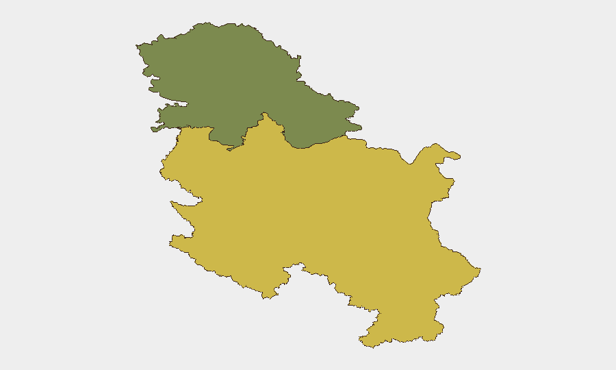
Central Serbia (composite risk 65) significantly outranks Vojvodina (risk 35) as the primary threat concentration. Central Serbia's elevated profile reflects protest frequency (Valjevo, Belgrade), incidents of interpersonal violence (Zemun Polje), and arson targeting (Stari Grad district), combined with ongoing wildfire emergencies affecting the Deliblatska Peščara reserve and areas near major transport arteries. Vojvodina presents secondary risk but warrants continued monitoring given its administrative importance and connectivity to unrest epicenters.
How GeoBit Would Assist
Teams operating in Serbia should deploy AOI Monitoring & Early Warning on Central Serbia administrative areas and key infrastructure sites (Deliblatska Peščara, Ibarska Highway approaches, Belgrade protest-prone districts) for persistent real-time alerting. Intel Sweep and OSINT fusion capabilities enable 24–48-hour corroboration of protest announcements, wildfire progression, and emerging violence signals across social media, local news, and official channels. Routing & Network Analysis functionality supports alternative journey planning for personnel and supply chains, accounting for both protest-related street closures and wildfire-driven highway impacts; GIS & Spatial Analysis maps high-risk districts and safe corridor options dynamically.
7-Day Outlook
The planned 23 August Belgrade protest carries immediate crowd-control and transport disruption risk through the weekend. Wildfire containment in Deliblatska Peščara and peripheral areas will likely dominate next 48–72 hours; resolution or escalation will determine whether travel restrictions persist. Absent major political flashpoint or secondary violence incidents, underlying civil-unrest risk is expected to remain elevated but episodic rather than systemic through early September.
Highest-Risk Areas — Ranked
| # | State / Region | Risk |
|---|---|---|
| 1 | Central Serbia | 65 |
| 2 | Vojvodina | 35 |
Sources
Previous Daily Briefs
A new Serbia brief is written every day — each with its own risk map and downloadable CSV. Here's the last week; use the calendar to go further back.
- August 21, 2026
- August 19, 2026
- August 17, 2026
- August 15, 2026
- August 13, 2026
- August 11, 2026
- August 9, 2026
📅 Browse every day by calendar →
Highlighted days have a brief. Tap a day for that day's map & analysis, or “csv” for that day's dataset ($5).
Atlas — our AI intelligence desk — emails them this snapshot personally. Nothing else, no list.