Situation Summary
Tunisia remains classified as a moderate global terrorism and insurgency risk (#77 globally, composite score 21), with no tracked active events in the last 24 hours. However, concurrent humanitarian, law-enforcement, and border-control incidents over the past 5 days point to cumulative strain on state capacity and public order. The security picture is regionally fragmented: insurgency-driven risk concentrates in the western and southern border zones, while urban crime and civil unrest manifest in the capital and coastal areas.
Key Developments
- Tunis (Bab Souika, Bab Saadoun, Halfaouine, Bab Jedid) — 2026-08-06: National police executed a coordinated security sweep, detaining 15 wanted individuals on charges of violent theft, aggravated theft, assault, criminal association, and property offenses. Operation reflects elevated law-enforcement activity in the capital's older quarters.
- Gabès — 2026-08-09: Over 200 civilians hospitalized due to pollution from phosphate processing operations; public anger and protest activity reported over plant closure demands. Represents significant civilian health incident and mounting social pressure in the southern industrial zone.
- Tunisia–Libya border (Ras Jdir crossing) — date not precisely specified in current reports: Border crossing reportedly closed following a security incident; status of re-opening unclear. Relevant for supply-chain and cross-border movement planning.
- National emergency response — 2026-08-05 to 2026-08-06: Civil Protection logged 646 interventions in 24 hours, including 164 firefighting operations and road rescues, indicating sustained demand on emergency services.
- Tunis railway corridor — date not specified: Traffic disruption reported between Tunis and Jebel Jelloud stations; duration and cause not clarified in available reports.
Highest-Risk Areas
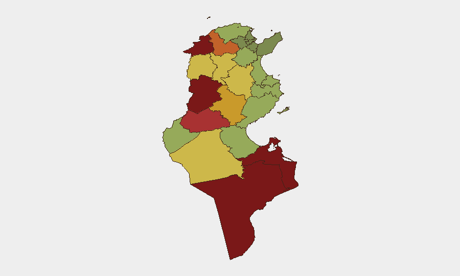
Kasserine (risk 92), Jendouba (88), and Tataouine (85) drive the sub-national threat index and reflect the persistence of terrorist/insurgent activity in Tunisia's western and southern border regions adjacent to Libya and Algeria. These areas remain conduits for weapons trafficking, foreign fighter transit, and militant recruitment. Secondary risk clusters in Médenine (83) and Gafsa (78) indicate a broader vulnerability arc along the Libyan border and in remote southwestern governorates. By contrast, greater Tunis and coastal urban centers face lower insurgency risk but elevated petty crime, organized theft, and civil-disorder potential, as illustrated by the 2026-08-06 police operation and ongoing Gabès unrest.
How GeoBit Would Assist
Security and duty-of-care teams with personnel or assets in Tunisia should employ AOI Monitoring & Early Warning on Kasserine, Jendouba, and Tataouine to detect militant movement or attack precursors; Routing & Network Analysis to plan safer, real-time alternative routes around Ras Jdir and Libyan border closures; and Intel Sweep with X/Twitter & Telegram OSINT to track emerging civil unrest (e.g., Gabès protests) and labor/political instability in urban centers. Entity extraction and sentiment analysis of local media and social platforms will provide 48-72-hour leading indicators of transport disruption, strikes, or public-order incidents.
7-Day Outlook
No imminent escalation in terrorism is forecasted, but operational fragility persists: border closures, industrial-accident fallout, and police activity suggest friction across multiple governance domains. Travel delays and minor security cordons around Kasserine–Jendouba–Tataouine remain probable; coastal routes and Tunis metro zones are passable but warrant real-time incident monitoring for crime and transport disruption.
Highest-Risk Areas — Ranked
| # | State / Region | Risk |
|---|---|---|
| 1 | Kasserine | 92 |
| 2 | Jendouba | 88 |
| 3 | Tataouine | 85 |
| 4 | Médenine | 83 |
| 5 | Gafsa | 78 |
| 6 | Béja | 75 |
| 7 | Sidi Bouzid | 72 |
| 8 | Al Kaf | 70 |
| 9 | Kébili | 68 |
| 10 | Kairouan | 65 |
| 11 | Siliana | 62 |
| 12 | Tozeur | 58 |
Sources
Previous Daily Briefs
A new Tunisia brief is written every day — each with its own risk map and downloadable CSV. Here's the last week; use the calendar to go further back.
📅 Browse every day by calendar →
Highlighted days have a brief. Tap a day for that day's map & analysis, or “csv” for that day's dataset ($5).
Atlas — our AI intelligence desk — emails them this snapshot personally. Nothing else, no list.