Situation Summary
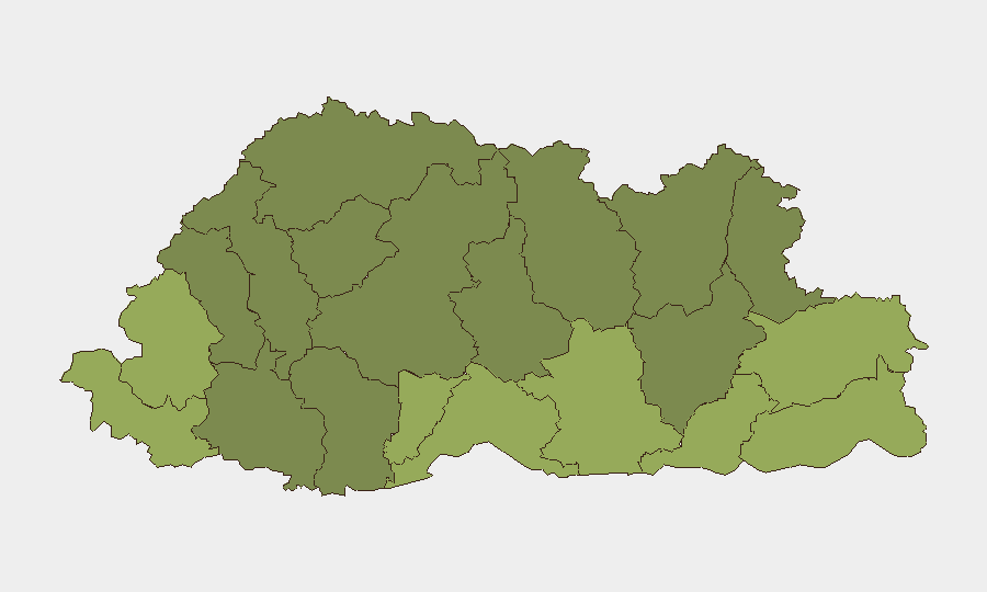
Bhutan maintains a stable security environment with no verified incidents, civil unrest, or infrastructure disruptions reported in the last 24–48 hours. The country's composite threat score remains at 2 globally, reflecting low incidence of tracked security events. Risk remains structurally elevated in border districts—particularly Samtse, Sarpang, and Haa—but without acute triggering incidents in the current reporting window, the overall trajectory is one of continued stability.
Key Developments
No discrete security, crime, civil unrest, or infrastructure incidents meeting verification and recency criteria (last 24–48 hours) were identified in independent Bhutanese media, open-source reporting, or regional monitoring during this period. Available coverage from Bhutan Broadcasting Service (BBS), Daily Bhutan, Bhutan Post, and regional sources contains no newly dated event reports that would constitute a current development for corporate security planning.
Highest-Risk Areas
Samtse District (risk 58), Sarpang District (risk 55), and Haa District (risk 52) dominate the sub-national ranking and reflect structural vulnerabilities typical of border regions: proximity to India–Bhutan frontier management, cross-border movement pressures, and limited state capacity in remote terrain. Pemagatshel, Samdrup Jongkhar, and Tsirang districts follow at moderate-to-elevated levels. These eastern and southern border areas merit elevated monitoring for illicit trade, unauthorized border crossing, and localized criminal activity, though none have generated acute incidents in the current window. Central and northern districts (Thimphu excepted) show lower composite risk but remain subject to seasonal and environmental disruptions (monsoon damage, road infrastructure).
How GeoBit Would Assist
Security teams with personnel or assets in Bhutan should employ AOI Monitoring & Early Warning focused on the highest-risk border districts to detect early signals of unrest, infrastructure failure, or cross-border incidents before they escalate. OSINT fusion & corroboration across Bhutanese media, regional reporting, and diplomatic channels will provide continuous verification of stability claims and early detection of emerging issues. For travel and logistics planning, Routing & Network Analysis can identify alternative routes and safe corridors in border zones, particularly during monsoon season or periods of elevated cross-border activity.
7-Day Outlook
No specific acute threats are forecast for the next 7 days based on current reporting and trends. Risk remains elevated in border districts as a structural feature rather than an acute event; seasonal infrastructure challenges (monsoon-related road damage) may affect logistics in southern and eastern zones but do not present direct security risks to corporate operations. Continued monitoring of India–Bhutan diplomatic engagement and routine border management is advisable as a baseline precaution, but no escalation in unrest or political instability is anticipated in the near term.
REPORT METADATA
*Date: 2026-08-05 | Scope: Bhutan | Confidence Level: High (absence of reported incidents) | Next Update: 2026-08-06*
Highest-Risk Areas — Ranked
| # | State / Region | Risk |
|---|---|---|
| 1 | Samtse District | 58 |
| 2 | Sarpang District | 55 |
| 3 | Haa District | 52 |
| 4 | Pemagatshel District | 50 |
| 5 | Samdrup Jongkhar District | 48 |
| 6 | Tsirang District | 45 |
| 7 | Zhemgang District | 42 |
| 8 | Trashigang District | 40 |
| 9 | Mongar District | 38 |
| 10 | Gasa District | 35 |
| 11 | Lhuntse District | 32 |
| 12 | Wangdue Phodrang District | 30 |
Sources
Previous Daily Briefs
A new Bhutan brief is written every day — each with its own risk map and downloadable CSV. Here's the last week; use the calendar to go further back.
📅 Browse every day by calendar →
Highlighted days have a brief. Tap a day for that day's map & analysis, or “csv” for that day's dataset ($5).
Atlas — our AI intelligence desk — emails them this snapshot personally. Nothing else, no list.