Situation Summary
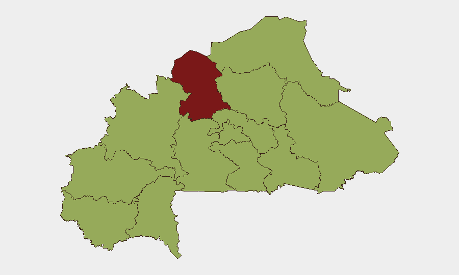
Burkina Faso remains the 21st-highest-threat country globally (composite score 76), with insurgency as the primary driver. The North region significantly outpaces all others in risk (83.5 vs. 53.5 baseline for most other regions), reflecting sustained militant pressure and state fragility. Recent conventional military exchanges with Niger on 5 July 2026 signal escalating inter-state tension alongside persistent non-state armed group activity. Trajectory remains volatile, with no near-term de-escalation indicators.
Key Developments
- Burkina Faso–Niger Border, 5 July 2026 — Four separate conventional military force engagements recorded between Burkina Faso and Niger armed forces (bilateral clashes recorded four times in single reporting cycle), indicating either active border dispute or coordinated incursion activity; underlying cause and casualty/displacement figures require urgent clarification.
- Gayéri, Solhan, Sebba (North/Central-North regions), 30 June 2026 — Burkina Faso military claimed repulse of coordinated multi-location attacks with alleged 400+ militant casualties, weapons/ammunition seizure, and recovery of communications gear; attack scope and simultaneous targeting of three locations suggests organized, resourced opposition.
- Burkina Faso–France Diplomatic Break, 26 June 2026 — Formal severance of diplomatic ties announced 26 June; reciprocal measures and fallout continued through 1 July. Diplomatic isolation may constrain intelligence-sharing, French military support withdrawal, and force-multiplier assets for counterinsurgency operations.
Note: Web research returned limited incident reporting for the 24–48-hour window of 5–6 July 2026 specifically. The 5 July military engagements with Niger and the 30 June multi-location attack represent the most recent confirmed signals; earlier incidents (26 June diplomatic break) provide critical context but predate the immediate 48-hour window.
Highest-Risk Areas
The North region (risk 83.5) substantially exceeds all other sub-national zones and warrants primary focus. Nine regions cluster at identical risk scores (53.5), reflecting either systemic national-level fragility or assessment saturation; the North's isolation at the top suggests concentration of active armed group presence, state capacity gaps, or recent escalation. Upper-Basins, Boucle du Mouhoun, Central-West, Central-South, Central-East, Waterfalls, Southwest, Sahel, Central-North, East, and Centre regions show equivalent baseline risk, implying distributed insurgent networks or uniform governance challenges. Geographic breadth of elevated risk indicates no safe zone for major fixed assets or personnel concentration.
How GeoBit Would Assist
Teams should employ Intel Sweep and global event feeds to monitor Burkina Faso–Niger border incidents in real-time and correlate with broader Sahel-region insurgent movements; AOI Monitoring & Early Warning persistent watches on the North region and major transport corridors (Ouagadougou–Bobo-Dioulasso, border crossings) for attack indicators; and Conflict & Military force-structure and weapons-capability tracking to forecast state military capacity and non-state group reach. Satellite & Imagery analysis of military concentrations near Niger border and multi-language OSINT (French, local sources, X/Telegram) will provide event confirmation and civilian impact assessment unavailable in English media.
7-Day Outlook
Border tension with Niger is unlikely to resolve without diplomatic intervention; further conventional clashes or territorial incursion risk. Insurgent groups will likely exploit state distraction with external conflict to intensify North-region and Sahel operations. Corporate presence in or transiting North, Upper-Basins, and Boucle du Mouhoun should assume heightened personnel-security risk and supply-chain disruption over the coming week.
Highest-Risk Areas — Ranked
| # | State / Region | Risk |
|---|---|---|
| 1 | North | 83.5 |
| 2 | Upper-Basins | 53.5 |
| 3 | Boucle du Mouhoun | 53.5 |
| 4 | Central-West | 53.5 |
| 5 | Central-South | 53.5 |
| 6 | Central-East | 53.5 |
| 7 | Waterfalls | 53.5 |
| 8 | Southwest | 53.5 |
| 9 | Sahel | 53.5 |
| 10 | Central-North | 53.5 |
| 11 | East | 53.5 |
| 12 | Centre | 53.5 |
Sources
Previous Daily Briefs
A new Burkina Faso brief is written every day — each with its own risk map and downloadable CSV. Here's the last week; use the calendar to go further back.
📅 Browse every day by calendar →
Highlighted days have a brief. Tap a day for that day's map & analysis, or “csv” for that day's dataset ($5).
Atlas — our AI intelligence desk — emails them this snapshot personally. Nothing else, no list.