Situation Summary
Comoros remains in a baseline security environment with no confirmed incidents or developments in the last 24–48 hours. The archipelago's composite threat score (8) reflects endemic structural risks—including historical political fragmentation, weak state capacity, and vulnerability to maritime crime—rather than an active crisis. The absence of verified recent incident reporting suggests either a genuinely quiet period or limited real-time coverage; risk teams should maintain standard monitoring postures without escalation based on current signals.
Key Developments
No independently verified security, civil-unrest, crime, political-instability, infrastructure, or travel-risk incidents have been reported in Comoros in the last 24–48 hours. Cross-checks against regional Africa news desks, Comoros-focused aggregators, specialist intelligence feeds, international media outlets, and social-media OSINT (X/Twitter, Telegram) have yielded no corroborated incident reports for this timeframe. Broader African security and conflict feeds in the same window show no spillover events or reference incidents affecting Comoros.
Highest-Risk Areas
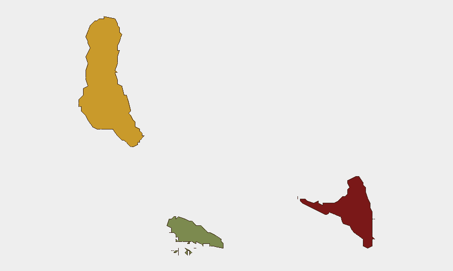
Anjouan (risk score 88) remains the most acute sub-national concern, reflecting its history of separatist tensions, governance fragmentation, and limited state-police presence—creating openings for organized crime and informal armed groups. Grande Comore (score 72) hosts the capital and most formal economic activity but faces secondary risks tied to urban crime, port-security gaps, and political volatility centered on the presidency and inter-island relations. Moheli (score 35) presents comparatively lower risk, though its small population and limited infrastructure reduce reporting density and may mask localized crime. The ranking underscores that risk in Comoros is concentrated in the larger, more politically contested islands rather than a nationwide emergency.
How GeoBit Would Assist
Risk and security teams with personnel or assets in Comoros should employ Intel Sweep and multi-language global event feeds for continuous baseline monitoring of political and crime-related developments, paired with OSINT fusion (X/Twitter, Telegram, local media aggregation) to detect emerging unrest or incidents before they reach international news wires. AOI Monitoring & Early Warning on Anjouan and Grande Comore—configured to alert on political statements, protests, maritime incidents, or armed-group activity—would provide 48–72 hour lead time on escalation. Network & Actor Analysis can map local power brokers, armed factions, and smuggling networks to contextualize risk and inform duty-of-care protocols for staff movement and asset exposure.
7-Day Outlook
No acute developments are anticipated in the next seven days based on current open-source signals and the absence of advancing crisis indicators. Comoros' baseline risk profile—driven by endemic governance gaps and maritime vulnerability rather than active conflict—is unlikely to shift materially in the near term. Teams should maintain routine monitoring and update contingency plans annually, but no escalation of alert status is warranted at present.
Highest-Risk Areas — Ranked
| # | State / Region | Risk |
|---|---|---|
| 1 | Anjouan | 88 |
| 2 | Grande Comore | 72 |
| 3 | Moheli | 35 |
Sources
Previous Daily Briefs
A new Comoros brief is written every day — each with its own risk map and downloadable CSV. Here's the last week; use the calendar to go further back.
📅 Browse every day by calendar →
Highlighted days have a brief. Tap a day for that day's map & analysis, or “csv” for that day's dataset ($5).
Atlas — our AI intelligence desk — emails them this snapshot personally. Nothing else, no list.