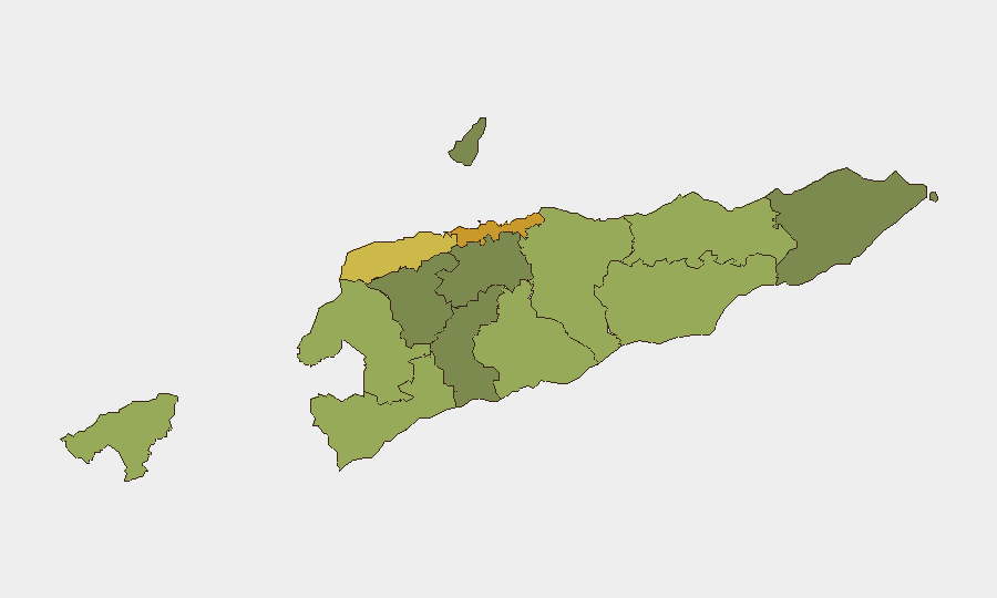
Situation Summary
East Timor remains at low acute risk (global rank #177, composite threat score 4). No discrete security incidents, unrest, or infrastructure disruptions have been reported in the last 24–48 hours across national or city-level sources. Baseline conditions reflect endemic low-intensity street crime, localized disputes, and periodic governance challenges typical of the operating environment; no sudden deterioration is evident in current open reporting.
Key Developments
- Pacific Partnership 2026 deployment in Dili (12–26 August). U.S. Navy–led humanitarian and disaster-management mission with partner militaries and civil authorities concluding activities in the capital. No security incidents, protests, or disruptions associated with the exercise have been reported as of latest updates.
- CPLP Council of Ministers convened in Dili. Community of Portuguese-Speaking Countries ministerial meeting held in the capital; session focused on Guinea-Bissau political situation. No local security incidents or official disruptions reported.
- No verified acute incidents reported (25–26 August 2026). Web search across regional and international sources yields no multi-sourced reports of violence, crime spikes, political unrest, infrastructure failure, or sudden instability in Timor-Leste within the last 24–48 hours.
Highest-Risk Areas
Dili (risk 72) dominates the sub-national profile and accounts for a significant proportion of the country's overall threat concentration, reflecting its role as capital, largest urban center, and hub for organized activity. Liquiçá (62) and Baucau (58) follow as secondary concern zones; Liquiçá's proximity to the western border and Baucau's location on the eastern side of the island expose both to cross-border movement and localized resource disputes. The western border districts (Liquiçá, Cova Lima, Bobonaro) collectively carry elevated risk due to porous boundaries, informal trade, and periodic land-tenure conflicts. All outlying districts (Aileu, Ermera, Ainaro) register lower risk, suggesting violence and organized crime remain concentrated in urban and border areas.
How GeoBit Would Assist
A corporate security team with personnel or assets in Timor-Leste should employ AOI Monitoring & Early Warning on Dili and key border districts (Liquiçá, Bobonaro) to detect acute incidents, unrest, or infrastructure failures as they emerge; multi-language Intel Sweep and regional event feed monitoring to catch local- and regional-language reporting that may precede English-language coverage; and Routing & Network Analysis to maintain pre-planned alternative movement corridors and supply chains in case of localized disruption, particularly for staff in high-risk districts. These capabilities enable persistent, low-overhead surveillance and rapid escalation protocols without reliance on single-source news feeds.
7-Day Outlook
No indicators suggest escalation of baseline risk over the next 7 days. The concluding Pacific Partnership activities and CPLP ministerial are low-risk, planned events unlikely to generate secondary unrest. Standard monitoring protocols for crime, border activity, and political speech should remain in place; no elevated alert status is warranted at present based on current intelligence.
Highest-Risk Areas — Ranked
| # | State / Region | Risk |
|---|---|---|
| 1 | Dili | 72 |
| 2 | Liquiçá | 62 |
| 3 | Baucau | 58 |
| 4 | Cova Lima | 55 |
| 5 | Bobonaro | 53 |
| 6 | Oecussi-Ambeno | 48 |
| 7 | Manufahi | 45 |
| 8 | Viqueque | 42 |
| 9 | Manatuto | 40 |
| 10 | Ainaro | 38 |
| 11 | Ermera | 36 |
| 12 | Aileu | 32 |
Sources
Previous Daily Briefs
A new East Timor brief is written every day — each with its own risk map and downloadable CSV. Here's the last week; use the calendar to go further back.
- August 23, 2026
- August 20, 2026
- August 18, 2026
- August 16, 2026
- August 14, 2026
- August 12, 2026
- August 10, 2026
📅 Browse every day by calendar →
Highlighted days have a brief. Tap a day for that day's map & analysis, or “csv” for that day's dataset ($5).
Atlas — our AI intelligence desk — emails them this snapshot personally. Nothing else, no list.