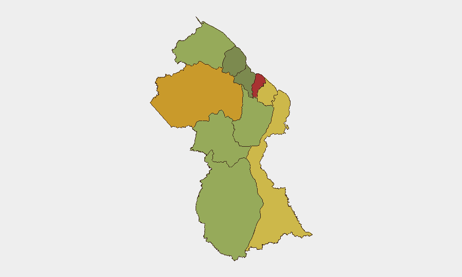
Situation Summary
Guyana remains a low-to-moderate threat environment globally (#109, composite score 14) with no discrete security incidents recorded in the past 24–48 hours. However, recent developments—including a fatal traffic crash near the international airport, an active maritime law-enforcement operation, and ongoing land-access tensions in the interior—indicate localized vulnerabilities in transport corridors, coastal waters, and resource-extraction zones. The security picture is stable but fragmented by region, with Demerara-Mahaica (risk 78) and Cuyuni-Mazaruni (risk 72) presenting significantly elevated exposure compared to other administrative regions.
Key Developments
- Timehri Public Road, East Bank Demerara – fatal multi-vehicle crash (29 Aug, early morning)
A sand truck struck two minibuses, killing two Indonesian nationals and injuring four foreign nationals. This incident underscores heightened road-safety risk on a major airport-access corridor and affects ground-transport planning for personnel shuttles in that zone.
- Friendship, East Bank Demerara – opposition leader's vessel intercepted by police and Coast Guard (25–29 Aug)
A joint GPF–GDF patrol stopped a speeding go-fast craft; the vessel and operator later found unlicensed under Defence Act enforcement. Investigation and licensing disputes remain active; contributes to maritime security and political sensitivity but core incident predates your window.
- Georgetown, Ruimveldt – maritime enforcement and licensing assertions (26–29 Aug)
Maritime Administration Department reinforced unlicensed-operator enforcement posture. Signals assertive law-enforcement activity in coastal/river transit zones near Georgetown.
- Georgetown, Woolford Avenue (CIOG compound) – multi-million-dollar robbery remand hearing (18 Aug incident; 26 Aug court action)
A 29-year-old taxi driver and associates arrested and remanded on robbery-under-arms charges after armed theft of G$3.8 million. Reflects organized property crime targeting higher-value facilities in central Georgetown; legal proceedings ongoing.
- Chinese Landing, Region 1 (Barima-Waini) – Amerindian land-access blockade and mining dispute (27–29 Aug)
The Amerindian People's Association reported community blockades of mining equipment and called for government intervention to halt reported encroachment. Active local resource-conflict tension with potential for resident–mining-operator confrontations in interior zones.
Highest-Risk Areas
Demerara-Mahaica and Cuyuni-Mazaruni drive the country-level risk profile, driven by higher concentrations of urban crime, trafficking activity, and maritime enforcement operations in the capital region and river corridors. East Berbice-Corentyne and Mahaica-Berbice follow closely, reflecting ongoing crime and smuggling pressures. Interior regions (Barima-Waini, Upper Takutu-Upper Essequibo, Potaro-Siparuni) register moderate-to-low scores but show episodic land-rights and resource-extraction friction; Essequibo Islands presents the lowest ranked risk but warrants monitoring given maritime-access and offshore-industry exposure.
How GeoBit Would Assist
Security teams should employ AOI Monitoring & Early Warning on Demerara-Mahaica, East Bank Demerara transport corridors, and interior mining zones to detect emerging confrontations or enforcement activity. Maritime & Aviation Tracking combined with OSINT fusion on coastal and river-patrol operations will provide real-time visibility into law-enforcement postures and vessel movements. Routing & Network Analysis capabilities enable identification of safer ground-transport alternatives around high-incident zones (e.g., Timehri Public Road) and contingency planning for river and coastal operations.
7-Day Outlook
No major escalation is forecast. Routine maritime enforcement and interior land-rights disputes are likely to persist at current low-intensity levels. The fatal traffic crash may prompt temporary heightened awareness among transport operators but poses no broader systemic risk. Monitoring should remain focused on Demerara-Mahaica urban crime trends and interior resource-conflict signals.
Highest-Risk Areas — Ranked
| # | State / Region | Risk |
|---|---|---|
| 1 | Demerara-Mahaica | 78 |
| 2 | Cuyuni-Mazaruni | 72 |
| 3 | Mahaica-Berbice | 65 |
| 4 | East Berbice-Corentyne | 62 |
| 5 | Upper Demerara-Berbice | 58 |
| 6 | Potaro-Siparuni | 48 |
| 7 | Barima-Waini | 45 |
| 8 | Upper Takutu-Upper Essequibo | 42 |
| 9 | Pomeroon-Supenaam | 38 |
| 10 | Essequibo Islands | 35 |
Sources
Previous Daily Briefs
A new Guyana brief is written every day — each with its own risk map and downloadable CSV. Here's the last week; use the calendar to go further back.
- August 27, 2026
- August 25, 2026
- August 23, 2026
- August 21, 2026
- August 19, 2026
- August 17, 2026
- August 15, 2026
📅 Browse every day by calendar →
Highlighted days have a brief. Tap a day for that day's map & analysis, or “csv” for that day's dataset ($5).
Atlas — our AI intelligence desk — emails them this snapshot personally. Nothing else, no list.