Situation Summary
Ivory Coast remains a fragmented security landscape with concentrated risk in the northern and northeastern interior regions, while major urban centers and southern commercial zones maintain relative stability. The national threat ranking (#70 globally, composite score 25) reflects persistent but localized challenges: labor agitation, informal-sector violence, artisanal mining enforcement, and sporadic commercial crime. No credible new security incidents have been confirmed in the last 24–48 hours; recent event signals cluster around late August trends in informal racketeering, mining enforcement, and labor disputes rather than systemic escalation.
Key Developments
No confirmed security incidents meeting cross-source verification standards have been identified in Ivory Coast for the period 2026-08-21 to 2026-08-23.
Background context (not current developments, but recent drivers):
- 2026-08-21 · Savanes/Korhogo corridor: Death of customs officer Coulibaly Lamtou Aimé following assault by gnambros (informal transport-checkpoint racketeers)—signals ongoing vulnerability of administrative personnel to informal-sector violence in northern transit zones.
- 2026-08-20 · Abidjan/national: Five unions mobilized over 39 billion CFA franc tax-administration dispute; represents sustained labor agitation risk in the public sector over the medium term.
- 2026-08-17 · Comoé District: Gendarmerie arrested 70 miners and destroyed 56 dredges on Comoé River in intensified nationwide artisanal-mining crackdown; reflects resource-control enforcement and potential flashpoint for localized resistance.
- 2026-08-15 · Bangolo (Gôh-Djiboua): Mobile phone shop burglary as part of recurrent commercial-theft pattern; indicates persistent petty organized crime affecting town-level merchant security.
No incidents in Abidjan or southern coastal commercial zones reported in the specified window.
Highest-Risk Areas
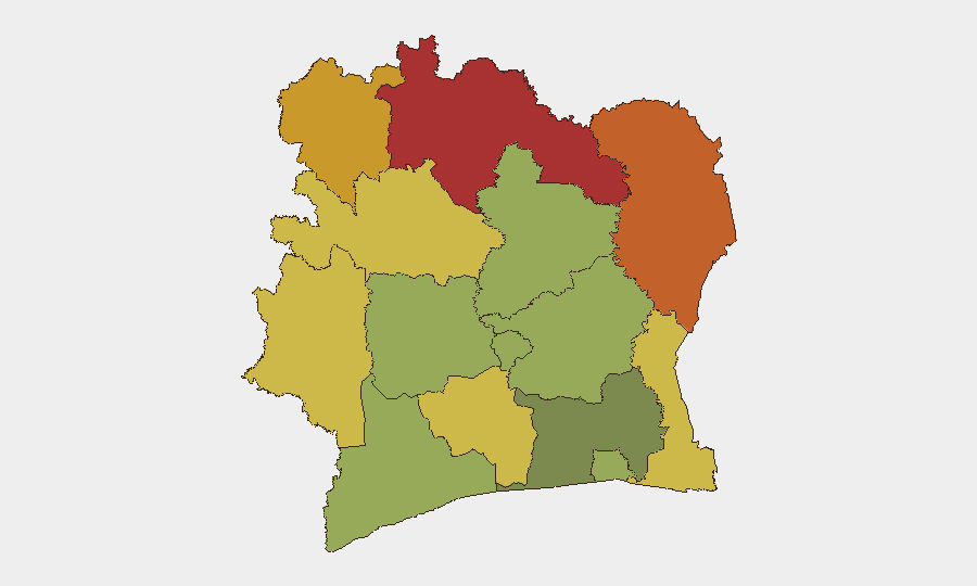
The northern and northeastern districts—Savanes, Zanzan, Denguélé, and Comoé (risk scores 78, 75, 72, 70 respectively)—account for the majority of Ivory Coast's tracked threat profile. These regions share characteristics: informal cross-border transit (Guinea, Mali, Burkina Faso), sparse state capacity, artisanal mining activity, and reliance on informal transport networks vulnerable to racketeering and ad-hoc taxation. Savanes in particular has emerged as a focal point for violence against state personnel. The southern interior (Montagnes, Woroba, Gôh-Djiboua) presents secondary risk clusters linked to commercial crime and localized tensions. By contrast, Abidjan and coastal Bas-Sassandra remain significantly lower-risk, reflecting stronger police presence and formalized commercial infrastructure.
How GeoBit Would Assist
Duty-of-care teams with personnel or assets in northern districts should employ Area-of-Interest Monitoring & Early Warning on Savanes, Zanzan, and Comoé to detect emerging racketeering, enforcement operations, or labor action before operational impact. Multi-language OSINT and sentiment analysis across local media outlets (Koaci, Fraternité Matin, Abidjan.net), X/Twitter, and Telegram channels would provide real-time incident signals and union activity tracking. Risk & Threat Assessment paired with Network & Actor Analysis can map informal-sector power structures (gnambros, mining syndicates, checkpoint controllers) to identify contact and avoidance protocols for high-risk transit corridors.
7-Day Outlook
Near-term trajectory remains stable at the national level but fragmented regionally. Labor disputes over the tax-administration shortfall may persist into early September, creating secondary crowd-management risks in Abidjan. Northern mining enforcement is likely to continue, with attendant potential for localized resistance or informal-sector retaliation against officials. No indicators suggest imminent escalation to organized armed activity or major civil unrest.
Highest-Risk Areas — Ranked
| # | State / Region | Risk |
|---|---|---|
| 1 | Savanes District | 78 |
| 2 | Zanzan District | 75 |
| 3 | Denguélé District | 72 |
| 4 | Comoé District | 70 |
| 5 | Montagnes District | 68 |
| 6 | Woroba District | 65 |
| 7 | Gôh-Djiboua District | 60 |
| 8 | Sassandra-Marahoué District | 58 |
| 9 | Vallée du Bandama District | 55 |
| 10 | Bas-Sassandra District | 52 |
| 11 | Lacs District | 48 |
| 12 | Abidjan | 45 |
Sources
Previous Daily Briefs
A new Ivory Coast brief is written every day — each with its own risk map and downloadable CSV. Here's the last week; use the calendar to go further back.
- August 21, 2026
- August 20, 2026
- August 18, 2026
- August 17, 2026
- August 16, 2026
- August 14, 2026
- August 13, 2026
📅 Browse every day by calendar →
Highlighted days have a brief. Tap a day for that day's map & analysis, or “csv” for that day's dataset ($5).
Atlas — our AI intelligence desk — emails them this snapshot personally. Nothing else, no list.