Situation Summary
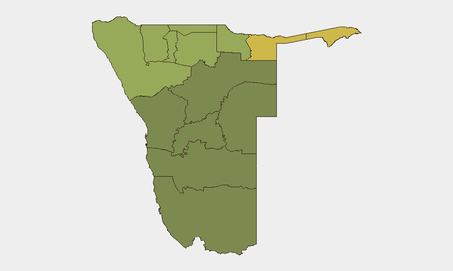
Namibia maintains a relatively stable security posture globally (rank #109, composite threat score 14) with no discrete security incidents tracked in the current reporting window. However, subnational risk remains concentrated in the northern border regions, particularly Zambezi, Kavango East, and Kavango West, where composite risk scores exceed 58–68. The absence of tracked events does not indicate absence of underlying vulnerabilities; rather, baseline conditions in frontier zones and informal settlements persist as structural drivers of organized crime, trafficking, and resource-conflict risk.
Key Developments
Unable to verify incident-level developments in the last 24–48 hours. Live web research as of 21 August 2026 does not surface well-sourced, time-stamped security, crime, unrest, or infrastructure incidents with explicit dates of 20–21 August 2026. Most available Namibian news items (including Nampa releases) are dated 15–20 August or earlier, and administrative announcements (e.g., a National Steering Committee launch in Windhoek on 21 August) do not constitute security incidents.
To obtain a reliable current incident list, targeted searches of Nampa, NBC Namibia, NamPol regional updates, and X/Twitter accounts of regional law-enforcement commands and journalists in Windhoek, Katima Mulilo, Oshakati, and Walvis Bay would be required, with cross-corroboration across at least two independent sources per event.
Highest-Risk Areas
Zambezi Region (risk 68) leads subnational rankings and reflects persistent trafficking, informal-settlement crime, and border-adjacent vulnerabilities linked to regional organized-crime networks and cross-border movement of contraband and persons. Kavango East and West (scores 62 and 58) share similar drivers: porous borders, low state capacity in remote districts, and competition for natural resources. Kunene and Oshikoto regions (scores 52 and 48) round out the highest-risk tier, influenced by pastoralist-community friction, informal mining, and sparse policing infrastructure. By contrast, coastal and central regions (Erongo, Hardap, Omaheke) and the capital-adjacent Oshana cluster score notably lower, reflecting stronger state presence and urban-economy resilience.
How GeoBit Would Assist
A Namibian security operation would deploy AOI Monitoring & Early Warning on Zambezi, Kavango, and Kunene districts to detect trafficking surges, informal-settlement unrest, or border-crossing anomalies with persistent alerting. Intel Sweep and X/Twitter OSINT against regional law-enforcement accounts, local journalists, and community networks would provide sub-24-hour visibility into crime incidents, protests, and accidents before they escalate. Network & Actor Analysis combined with entity extraction would map trafficking and organized-crime nodes across the Angolan, Zambian, and Botswanan borders, informing duty-of-care assessments for personnel and assets in frontier zones.
7-Day Outlook
No major escalation in national-level security risk is anticipated over the next seven days. However, routine criminal activity—theft, trafficking, informal-settlement disputes—will persist in northern border regions, and seasonal resource pressures may drive localized conflict in pastoral areas. Continuous subnational monitoring and cross-border intelligence sharing remain essential to early detection of organized-crime activity or mass-movement events.
Highest-Risk Areas — Ranked
| # | State / Region | Risk |
|---|---|---|
| 1 | Zambezi | 68 |
| 2 | Kavango East | 62 |
| 3 | Kavango West | 58 |
| 4 | Kunene Region | 52 |
| 5 | Oshikoto | 48 |
| 6 | Ohangwena | 45 |
| 7 | Omusati | 42 |
| 8 | Oshana | 40 |
| 9 | Otjozondjupa | 35 |
| 10 | Erongo Region | 32 |
| 11 | Hardap | 28 |
| 12 | Omaheke | 25 |
Sources
Previous Daily Briefs
A new Namibia brief is written every day — each with its own risk map and downloadable CSV. Here's the last week; use the calendar to go further back.
- August 19, 2026
- August 17, 2026
- August 15, 2026
- August 13, 2026
- August 11, 2026
- August 9, 2026
- August 7, 2026
📅 Browse every day by calendar →
Highlighted days have a brief. Tap a day for that day's map & analysis, or “csv” for that day's dataset ($5).
Atlas — our AI intelligence desk — emails them this snapshot personally. Nothing else, no list.