Situation Summary
Papua New Guinea maintains a composite threat score of 21 (global rank #84), with 0 tracked security events in the current cycle. The country faces persistent sub-national instability concentrated in the Highlands provinces, where tribal violence, illicit resource exploitation, and weak governance create chronic baseline risk. Near-term political uncertainty around Bougainville's independence referendum ratification has prompted official calls for calm and represents a medium-term governance and stability wild card. Seismic activity (two offshore and near-island earthquakes, 24–25 August) caused no reported casualties or infrastructure damage.
Key Developments
- Bougainville independence referendum enters parliament (Port Moresby, 27 August 2026). Papua New Guinea's parliament convened to consider ratification of the 2019 Bougainville independence referendum (97.7% voter support). This step raises medium-term political-stability and constitutional risk, with potential for tension among stakeholders.
- Prime Minister calls for calm amid Bougainville debate (Port Moresby, 27 August 2026). PM James Marape publicly urged "peace, wisdom, and informed deliberation" as parliament took up the independence process, signaling official concern about potential unrest or civil tension linked to the referendum outcome.
- Financial crime arrests in resource-rich Highlands (Tari and Porgera, Hela and Enga Provinces, 27 August 2026). Police arrested three suspects in connection with counterfeit gold transactions in both Tari and Porgera—areas with historical security volatility and illicit mining activity. The arrests indicate active enforcement in sensitive commodity crime.
- Seismic events, no major impact (Kimbe offshore and Panguna/Bougainville, 24–25 August 2026). Two earthquakes (magnitude 5.0 and 4.9) recorded off western and island regions; no tsunami, casualties, or major infrastructure damage reported. Standard geological risk for the region.
- Tribal-violence sentencing in Enga (Laiagam, Enga Province, sentenced 25 August 2026). A 22-year-old convicted of two killings linked to tribal retaliation received a 50-year sentence, illustrating ongoing cycle of inter-clan violence in the Highlands despite law-enforcement action.
Highest-Risk Areas
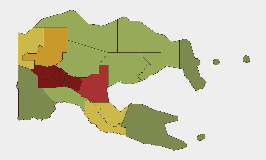
The Southern Highlands (risk 98), Enga (96), and Hela (94) provinces drive PNG's sub-national threat profile, followed by the broader Eastern and Western Highlands cluster (92–90). These regions are characterized by endemic tribal conflict, weak state security presence, illicit mining and commodity crime, and limited rule-of-law infrastructure. The National Capital District (85) ranks seventh, reflecting Port Moresby's urban crime and political-uncertainty risk. Organizations with personnel or assets in the top five provinces face elevated exposure to violence, kidnapping, robbery, and disruption tied to clan disputes and resource competition.
How GeoBit Would Assist
Security teams should employ AOI Monitoring & Early Warning on the five highest-risk Highlands provinces and Port Moresby to detect emerging tribal tensions, mining-sector incidents, or political unrest in near real-time. Network & Actor Analysis and Entity Extraction applied to local law-enforcement, media, and community reporting would map criminal and clan-faction activity patterns. Election Monitoring and Sentiment & Temporal Analysis capabilities are critical for tracking parliament's Bougainville debate and gauging likelihood of civil friction, while Routing & Network Analysis enables duty-of-care teams to plan safe transit corridors and alternate logistics in high-risk zones.
7-Day Outlook
Parliament's ongoing Bougainville ratification debate will remain the primary near-term political signal; outcomes in the next 5–7 days will clarify constitutional and regional-stability implications. Baseline Highlands tribal and resource-crime activity is expected to continue at current tempo. Seismic risk remains low absent further significant offshore events.
Highest-Risk Areas — Ranked
| # | State / Region | Risk |
|---|---|---|
| 1 | Southern Highlands | 98 |
| 2 | Enga | 96 |
| 3 | Hela | 94 |
| 4 | Eastern Highlands | 92 |
| 5 | Western Highlands | 90 |
| 6 | Jiwaka | 88 |
| 7 | National Capital District | 85 |
| 8 | Simbu | 82 |
| 9 | Morobe | 78 |
| 10 | East Sepik | 72 |
| 11 | Sandaun | 68 |
| 12 | Oro | 66 |
Sources
Previous Daily Briefs
A new Papua New Guinea brief is written every day — each with its own risk map and downloadable CSV. Here's the last week; use the calendar to go further back.
- August 25, 2026
- August 23, 2026
- August 21, 2026
- August 19, 2026
- August 17, 2026
- August 15, 2026
- August 13, 2026
📅 Browse every day by calendar →
Highlighted days have a brief. Tap a day for that day's map & analysis, or “csv” for that day's dataset ($5).
Atlas — our AI intelligence desk — emails them this snapshot personally. Nothing else, no list.