Situation Summary
Serbia remains at moderate composite threat level (rank #87 globally, score 19), with civil unrest as the primary driver. The security picture is currently dominated by environmental disasters (active wildfires across central and southern regions), isolated criminal incidents, and episodic student-led protests. No systemic instability is evident, but the concentration of wildfires, coupled with low-level violence and ongoing political tensions around war-crimes accountability, warrants continued monitoring of Central Serbia.
Key Developments
- Kraljevo traffic incident, 24–25 August. A passenger vehicle struck a mother and two children on a city-center sidewalk on Ulica Četvrtog kraljevačkog bataljona. The five-year-old victim is in critical condition; the driver has been arrested. This incident reflects ongoing road-safety risks in urban centers but carries no security implications beyond duty-of-care awareness.
- Deliblatska Peščara wildfire, 21–22 August. A major wildfire burned an 80 km southeast of Belgrade; Serbia activated EU Civil Protection mechanisms. While the immediate threat to populated areas has been contained, air quality and infrastructure access warrant monitoring through the week.
- Active wildfires near Niš, 22 August. Firefighting operations engaged in forested terrain near Niš; no buildings currently threatened but situation remains fluid. This represents the most significant environmental threat in the southern Central Serbia risk zone.
- Eco-Riot student protest, 23 August, Belgrade. Approximately 17:00 at Ušće Park, students organized the "Eko buna" (Eco Riot) protest in response to environmental degradation. The protest was orderly; no violence or significant disruption reported. This reflects broader youth mobilization around environmental policy but does not indicate escalating civil unrest.
- Incendiary device recovered near Brnjak, 22–23 August. A fireball incendiary device was launched from Kosovo territory and recovered near Brnjak on the night of 22–23 August. This represents the most significant security anomaly of the reporting period and warrants attribution analysis and cross-border monitoring.
- Church vandalism, Prizren, 23 August. A man damaged entrance doors and lighting at the Church of the Holy Savior (Serbian Orthodox site) in Prizren, Kosovo & Metohija. The suspect was charged and released into judicial proceedings. This reflects ongoing sectarian tension in disputed territories but remains a low-level incident.
- Assault in Zemun Polje, 20 August. Two adult males were assaulted at approximately 20:00 in the Zemun Polje neighborhood; one sustained skull fractures. Investigation status unknown; this reflects localized criminal violence rather than organized unrest.
- Ratko Mladić detention plea, 24 August. Serbian officials formally requested the release of convicted war criminal Ratko Mladić on health grounds, warning of imminent death. This adds to ongoing political friction around Serbia's relationship with international tribunals but has not triggered public unrest or violence to date.
Highest-Risk Areas
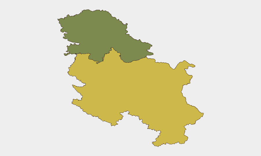
Central Serbia (composite risk 65) significantly outpaces Vojvodina (35), driven primarily by the current concentration of active wildfires, environmental degradation triggering youth mobilization, and proximity to Kosovo border tensions (evidenced by the Brnjak incendiary device). Vojvodina's lower risk reflects relative stability but does not eliminate operational exposure in Zemun or other urban centers. Teams with personnel or assets in Central Serbia—particularly in Niš, Kragujevac, and Belgrade corridors—should prioritize air-quality monitoring and cross-border incident tracking.
How GeoBit Would Assist
GeoBit's AOI Monitoring & Early Warning capability would track the Brnjak corridor and Kosovo border for repeat cross-border incidents; Satellite & Imagery Analysis would monitor active wildfire perimeters and air-quality risk in real time; and Intel Sweep (multi-language OSINT, Telegram, YouTube) would detect escalation signals in civil unrest or sectarian tensions before they reach mass-media reporting.
7-Day Outlook
Wildfires will likely persist through the week given seasonal conditions; air quality degradation may trigger additional environmental protests but does not presently indicate violence escalation. The Brnjak incident requires clarification on origin and intent; absent further cross-border provocations, baseline threat levels should remain stable. Teams should maintain heightened awareness of fire-zone access restrictions and monitor political rhetoric around Mladić detention for any spillover effects.
Highest-Risk Areas — Ranked
| # | State / Region | Risk |
|---|---|---|
| 1 | Central Serbia | 65 |
| 2 | Vojvodina | 35 |
Sources
Previous Daily Briefs
A new Serbia brief is written every day — each with its own risk map and downloadable CSV. Here's the last week; use the calendar to go further back.
- August 23, 2026
- August 21, 2026
- August 19, 2026
- August 17, 2026
- August 15, 2026
- August 13, 2026
- August 11, 2026
📅 Browse every day by calendar →
Highlighted days have a brief. Tap a day for that day's map & analysis, or “csv” for that day's dataset ($5).
Atlas — our AI intelligence desk — emails them this snapshot personally. Nothing else, no list.